Taksin Bridge
Taksin Bridge สะพานสมเด็จพระเจ้าตากสินมหาราช | |
|---|---|
 | |
| Coordinates | 13°43′08″N 100°30′45″E / 13.718791°N 100.512543°ECoordinates: 13°43′08″N 100°30′45″E / 13.718791°N 100.512543°E |
| Carries | 6 lanes of roadway, Bangkok Skytrain, pedestrians |
| Crosses | Chao Phraya River |
| Locale | Khlong San, Bang Rak, Sathon, Bangkok, Thailand |
| Official name | King Taksin Bridge |
| Characteristics | |
| Total length | 1,791 m |
| Longest span | 92 m |
| Clearance below | 12 m |
| History | |
| Construction start | 1 February 1979 |
| Construction end | 5 May 1982 |
| Opened | 6 May 1982 |
| Location | |
 | |

The Taksin Bridge (Thai: สะพานสมเด็จพระเจ้าตากสินมหาราช, RTGS: Saphan Somdet Phrachao Taksin Maha Rat, pronounced [sā.pʰāːn sǒm.dèt pʰráʔ.t͡ɕâːw tàːk.sǐn mā.hǎː râːt]; usually abbreviated to simply สะพานตากสิน, [sā.pʰāːn tàːk.sǐn]), or commonly known as Sathon Bridge (สะพานสาทร, RTGS: Saphan Sathon, [sā.pʰāːn sǎː.tʰɔ̄ːn]) is a bridge crossing the Chao Phraya River in Bangkok, Thailand.
History[]
It is the sixth bridge built across the Chao Phraya River to link Sathon and Krung Thon Buri Roads in Thonburi side (after Rama VI Bridge, Memorial Bridge, Krung Thon Bridge, Krungthep Bridge, Phra Pin Klao Bridge, chronologically). His Majesty the King Bhumibol Adulyadej (Rama IX) presided over the opening ceremony of the bridge on 6 May 1982 on the occasion of Rattanakosin's 200th anniversary. The bridge was named in honours King Taksin, the founder and ruler of Thonburi Kingdom.
Before the construction of the bridge, the Chao Phraya River was crowded with huge ocean-going steamers, cargo ships, and passenger ships passing up river to the port in the north of Bangkok. After completion of the bridge, the port was moved to the south at Bangkok Port, also known as Khlong Toei Port.
Characteristics[]
The bridge was designed with a large gap between opposing traffic directions to accommodate a canceled mass transit system. The disused foundations were eventually adapted for the BTS Skytrain,[1] with train services across the bridge beginning on 5 December 1999.[2][3][4]
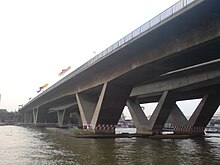
The entry ramp on the east side of the river contains the Saphan Taksin BTS Station as well as Sathorn Pier for the Chao Phraya Express Boat.[5][6]
See also[]
- Saphan Taksin BTS Station
References[]
- ^ "THE 1979 BANGKOK MASS TRANSIT MASTERPLAN". 2bangkok.com. Archived from the original on 2003-08-13. Retrieved 2007-11-27.
- ^ "ประวัติสะพานพระเจ้าตากมหาราช - สะพานต่าง ๆ ในประเทศไทย".
- ^ https://travel.mthai.com/tag/%E0%B8%AA%E0%B8%B0%E0%B8%9E%E0%B8%B2%E0%B8%99%E0%B8%AA%E0%B8%A1%E0%B9%80%E0%B8%94%E0%B9%87%E0%B8%88%E0%B8%9E%E0%B8%A3%E0%B8%B0%E0%B9%80%E0%B8%88%E0%B9%89%E0%B8%B2%E0%B8%95%E0%B8%B2%E0%B8%81%E0%B8%AA
- ^ "รถไฟฟ้าบีทีเอส (BTS Skytrain)".
- ^ https://www.lib.ru.ac.th/journal/bangkok/kingtaksin.html
- ^ "บีทีเอสเตรียมประมูล เม.ย.นี้ รื้อขยายสถานีตากสิน-สะพานสาทร". 10 March 2020.
External links[]
- Taksin Bridge Bureau of Maintenance and Traffic Safety, Thailand. Retrieved on 31 December 2007
This article about a bridge in Thailand is a stub. You can help Wikipedia by . |
- Bridges in Bangkok
- Bridges completed in 1982
- Crossings of the Chao Phraya River
- Road transport in Bangkok
- BTS Skytrain
- 1982 establishments in Thailand
- Asian bridge (structure) stubs
- Thai building and structure stubs
- Thailand transport stubs
- Bangkok stubs