List of districts of Bali
| This article is part of a series on |
| Subdivisions of Indonesia |
|---|
| Level 1 |
|
| Level 2 |
| (full list; cities by GDP; cities by population; regencies by population) |
| Level 3 |
| (kecamatan, distrik, kapanewon, or kemantren) |
| Level 4 |
| (desa or kelurahan) |
The province of Bali in Indonesia is divided into kabupaten or regencies, which in turn are divided administratively into districts, known as kecamatan. Province of Bali divided into 8 kabupaten, 1 kota, 57 kecamatan, 80 kelurahan, and 636 desa. In 2017, population is around 4.230.051 people with total area 5.780,06 km².[1][2]
| No. | Code Kemendagri |
Regency/City | Area (km²) |
Population (people) |
Density (people/km²) |
2017 | ||
|---|---|---|---|---|---|---|---|---|
| District | Sub-district | Village | ||||||
| 1 | 51.03 | Badung Regency | 418,62 | 468.346 | 1,118.79 | 6 | 16 | 46 |
| 2 | 51.06 | Bangli Regency | 490,71 | 264.945 | 539.92 | 4 | 4 | 68 |
| 3 | 51.08 | Buleleng Regency | 1.364,73 | 814.356 | 596.72 | 9 | 19 | 129 |
| 4 | 51.04 | 368,00 | 492.757 | 1,339.01 | 7 | 6 | 64 | |
| 5 | 51,01 | 841,8 | 323.211 | 383.95 | 5 | 10 | 41 | |
| 6 | 51.07 | 839,54 | 545.389 | 649.63 | 8 | 3 | 75 | |
| 7 | 51.05 | 315 | 215.852 | 685.24 | 4 | 6 | 53 | |
| 8 | 51.02 | 1.013,88 | 466.647 | 460.26 | 10 | - | 133 | |
| 9 | 51.71 | 127,78 | 638.548 | 4,997.25 | 4 | 16 | 27 | |
| Total Bali | 5.780,06 | 4.230.051 | 731.84 | 57 | 80 | 636 | ||
Badung Regency[]
Badung Regency has 6 district, 16 sub-district, and 46 village. In 2017, the population estimated 468.346 with area 418,62 km² and density 1.118 people/km².[1][2]
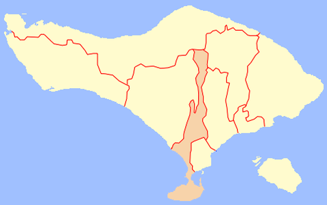
Map of Badung Regency in Bali

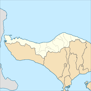
Map of districts in Badung Regency


List of districts and sub-districts in Badung Regency as follows:
| Code | Districts | Sub-districts | Village | Status | List |
|---|---|---|---|---|---|
| 51.03.03 | Abiansemal | - | 18 | Village | |
| 51.03.01 | Kuta | 5 | - | Sub-districts | |
| 51.03.05 | South Kuta | 3 | 3 | Village | |
| Sub-districts | |||||
| 51.03.06 | North Kuta | 3 | 3 | Village | |
| Sub-districts | |||||
| 51.03.02 | Mengwi | 5 | 15 | Village | |
| Sub-districts | |||||
| 51.03.04 | 7 | Village | |||
| TOTAL | 16 | 46 |
Bangli Regency[]
Bangli Regency has 4 district, 4 sub-district, and 68 villages. In 2017, the population estimated 264.945 with area 490,71 km² and density 540 people/km².[3][2]

Map of Bangli Regency in Bali

Map of districts in Bangli Regency


List of districts and sub-districts in Bangli Regency as follows:
| Code | Districts | Sub-districts | Village | Status | List |
|---|---|---|---|---|---|
| 51.06.02 | 4 | 5 | Village | ||
| Sub-districts | |||||
| 51.06.04 | Kintamani | - | 48 | Village | |
| 51.06.01 | - | 9 | Village | ||
| 51.06.03 | - | 6 | Village | ||
| TOTAL | 4 | 68 |
Buleleng Regency[]
Buleleng Regency has 9 district, 19 sub-district, and 129 villages. In 2017, the population estimated 814.356 with area 1.364,73 km² and density 598 people/km².[3][2]

Map of Buleleng Regency in Bali
Map of districts in Buleleng Regency


List of districts and sub-districts in Buleleng Regency as follows:
| Code | Districts | Sub-districts | Village | Status | List |
|---|---|---|---|---|---|
| 51.08.04 | Banjar | - | 17 | Desa | |
| 51.08.06 | Buleleng | 17 | 12 | Desa | |
| Kelurahan | |||||
| 51.08.03 | Busung Biu | - | 15 | Desa | |
| 51.08.01 | Gerokgak | - | 14 | Desa | |
| 51.08.08 | Kubutambahan | - | 13 | Desa | |
| 51.08.07 | Sawan | - | 14 | Desa | |
| 51.08.02 | Seririt | 1 | 20 | Desa | |
| Kelurahan | |||||
| 51.08.05 | Sukasada | 1 | 14 | Desa | |
| Kelurahan | |||||
| 51.08.09 | Tejakula | - | 10 | Desa | |
| TOTAL | 19 | 129 |
Gianyar Regency[]
Jembrana Regency[]
Karangasem Regency[]
Klungkung Regency[]
Tabanan Regency[]
Denpasar[]
List of districts[]
The districts of Bali, with the regency each falls into, are as follows:
- Abang, Karangasem
- Abiansemal, Badung
- Bangli, Bangli
- Banjar, Buleleng
- Banjarankan, Klungkung
- Baturiti, Tabanan
- Bebandem, Karangasem
- Blahbatuh, Gianyar
- Buleleng, Buleleng
- Busung Biu, Buleleng
- Dawan, Klungkung
- Denpasar Barat (West Denpasar), Denpasar
- Denpasar Selatan (South Denpasar), Denpasar
- Denpasar Timur (East Denpasar), Denpasar
- Gerokgak, Buleleng
- Gianyar, Gianyar
- Karangasem, Karangasem
- Kediri, Tabanan
- Kerambitan, Tabanan
- Kintamani, Bangli
- Klungkung, Klungkung
- Kubu, Karangasem
- Kubutambahan, Buleleng
- Kuta Selatan (South Kuta), Badung
- Kuta Utara (North Kuta), Badung
- Kuta, Badung
- Manggis, Karangasem
- Marga, Tabanan
- Melaya, Jembrana
- Mendoyo, Jembrana
- Mengwi, Badung
- Negara, Jembrana
- Nusa Penida, Klungkung
- Payangan, Gianyar
- Pekutatan, Jembrana
- Penebel, Tabanan
- Petang, Badung
- Pupuan, Tabanan
- Rendang, Karangasem
- Sawan, Buleleng
- Selat, Karangasem
- Selemadeg Bara, Tabanan
- Selemadeg Barat (West Selemadeg), Tabanan
- Selemadeg Timur (East Selemadeg), Tabanan
- Selemadeg, Tabanan
- Seririt, Buleleng
- Sidemen, Karangasem
- Sukasada, Buleleng
- Sukawati, Gianyar
- Susut, Bangli
- Tabanan, Tabanan
- Tampaksiring, Gianyar
- Tegallalang, Gianyar
- Tejakula, Buleleng
- Tembuku, Bangli
- Ubud, Gianyar.
References[]
- ^ a b "Peraturan Menteri Dalam Negeri Nomor 137 Tahun 2017 tentang Kode dan Data Wilayah Administrasi Pemerintahan". Kementerian Dalam Negeri Republik Indonesia. Archived from the original on 29 December 2018. Retrieved 3 October 2019.
- ^ a b c d "Peraturan Menteri Dalam Negeri Nomor 72 Tahun 2019 tentang Perubahan atas Permendagri nomor 137 Tahun 2017 tentang Kode dan Data Wilayah Administrasi Pemerintahan". Kementerian Dalam Negeri Republik Indonesia. Archived from the original (PDF) on 25 October 2019. Retrieved 15 January 2020.
- ^ a b "Peraturan Menteri Dalam Negeri Nomor 137 Tahun 2017 tentang Kode dan Data Wilayah Administrasi Pemerintahan". Kementerian Dalam Negeri Republik Indonesia. Archived from the original on 29 December 2018. Retrieved 3 October 2019.
- Districts of Bali
- Lists of districts of Indonesia