Denpasar
Denpasar | |
|---|---|
| City of Denpasar Kota Denpasar | |
| Other transcription(s) | |
| • Balinese | ᬤᬾᬦ᭄ᬧᬲᬃ |
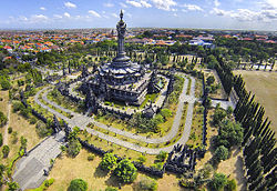 Aerial view of the Bajra Sandhi Monument | |
 Seal | |
| Motto(s): | |
 Location within Bali | |
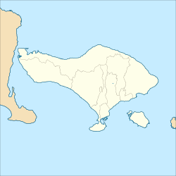 Denpasar | |
| Coordinates: 8°39′S 115°13′E / 8.650°S 115.217°ECoordinates: 8°39′S 115°13′E / 8.650°S 115.217°E | |
| Country | |
| Region | Lesser Sunda Islands |
| Province | |
| Settled | 27 February 1788 |
| Government | |
| • Mayor | I.B. Rai Dharmawijaya Mantra |
| • Vice Mayor | |
| Area | |
| • Total | 123.98 km2 (47.87 sq mi) |
| Elevation | 4 m (13 ft) |
| Population (2017) | |
| • Total | 897,300 |
| • Density | 7,200/km2 (19,000/sq mi) |
| [1][2] | |
| Demographics | |
| • Ethnic groups (2010) | Balinese (65.18%) Javanese (25.78%) Chinese (1.13%) Sasak (1.05%) Madura (0.78%) Sundanese (0.70%) Flores (0.53%) Batak (0.43%) others (4.42%)[3][4] |
| • Religion (2020) | Hinduism 67.3% Islam 22.8% Protestantism 5.04% Catholicism 2.36% Buddhism 2.37% Confucianism 0.03% Others 0.02% [5] |
| • Languages | Indonesian (official) Balinese (regional) English (international) Javanese (minority) |
| Time zone | UTC+8 (Indonesia Central Time) |
| Area code | (+62) 361 |
| Vehicle registration | DK |
| HDI | |
| Website | denpasarkota.go.id |


Denpasar (Indonesian pronunciation: [denˈpasar]) (Balinese: ᬤᬾᬦ᭄ᬧᬲᬃ) is the capital of Bali and the main gateway to the island. The city is also a hub for other cities in the Lesser Sunda Islands.
With the rapid growth of the tourism industry in Bali, Denpasar has encouraged and promoted business activities and ventures, contributing to it having the highest growth rate in Bali Province. The population of Denpasar was 897,300 in 2017,[1] up from 788,445 at the 2010 Census. The surrounding metropolitan area has roughly 2 million residents.
Etymology[]
The name Denpasar – from the Balinese words "den", meaning north, and "pasar", meaning market – indicates the city's origins as a market-town, on the site of what is now Kumbasari Market (formerly "Peken Payuk"), in the northern part of the modern city.[6]
History[]
Colonial era[]
In the 18th and 19th century, Denpasar functioned as the capital of the Hindu Majapahit Kingdom of Badung.[7] Thus, the city was formerly called Badung. The royal palace was looted and razed during the Dutch intervention in 1906. A statue in Taman Puputan (Denpasar's central square) commemorates the 1906 Puputan, in which as many as a thousand Balinese, including the King and his court, committed mass suicide in front of invading Dutch troops, rather than surrender to them.[8]
Independence era[]
In 1958, Denpasar became the seat of government for the Province of Bali. It remained the administrative centre of both Badung Regency and the City of Denpasar.[9]
Both Denpasar and Badung Regency have experienced rapid physical, economic, social and cultural growth.[9] Denpasar has become not only the seat of government, but also the centre of commerce, education, industry, and tourism.[9]
With an average population growth of 4.05% per annum, accompanied by rapid development, came a variety of urban problems. It was later resolved[when?] that meeting the needs and demands of the burgeoning urban community would be best addressed by giving Denpasar administrative independence from Badung Regency.[9] An agreement was reached to raise the status of Denpasar to that of an autonomous city, and on 15 January 1992, Act No. 1 of 1992 officially established the City of Denpasar. It was inaugurated by the Minister of Home Affairs on 27 February 1992.[9]
On 16 November 2009, in a further administrative realignment, Regulation Number 67 shifted the capital of Badung Regency from Denpasar to Mangupura.[citation needed]
Geography[]
Denpasar is located at an elevation of 4 m (13 ft) above sea level. While the total area of 127.78 km2 or 2.18% of the total area of Bali Province. From the use of land, 2,768 hectares of land are paddy, 10,001 hectares are dry land, while the remaining land area is 9 hectares.
Badung River divides Denpasar, after which the river empties into the Gulf of Benoa.[10]
Climate[]
Denpasar, located just south of the equator, has a tropical wet and dry climate (Köppen climate classification: Aw), with hot and humid weather year-round. Due to this there is little temperature change throughout the year, with temperatures averaging about 28 degrees Celsius. The year is divided into two seasons: wet and dry. The wet season lasts roughly from November to May, while the dry season lasts from June to October.
| hideClimate data for Denpasar, Bali | |||||||||||||
|---|---|---|---|---|---|---|---|---|---|---|---|---|---|
| Month | Jan | Feb | Mar | Apr | May | Jun | Jul | Aug | Sep | Oct | Nov | Dec | Year |
| Average high °C (°F) | 33.0 (91.4) |
33.4 (92.1) |
33.6 (92.5) |
34.4 (93.9) |
33.1 (91.6) |
31.4 (88.5) |
30.4 (86.7) |
29.6 (85.3) |
31.4 (88.5) |
33.6 (92.5) |
32.7 (90.9) |
33.0 (91.4) |
32.5 (90.4) |
| Daily mean °C (°F) | 28.6 (83.5) |
28.8 (83.8) |
28.8 (83.8) |
29.6 (85.3) |
28.6 (83.5) |
27.4 (81.3) |
26.7 (80.1) |
26.1 (79.0) |
27.1 (80.8) |
28.6 (83.5) |
28.1 (82.6) |
28.2 (82.8) |
28.1 (82.5) |
| Average low °C (°F) | 24.1 (75.4) |
24.2 (75.6) |
24.0 (75.2) |
24.8 (76.6) |
24.1 (75.4) |
23.5 (74.3) |
23.0 (73.4) |
22.5 (72.5) |
22.9 (73.2) |
23.7 (74.7) |
23.5 (74.3) |
23.5 (74.3) |
23.6 (74.6) |
| Average precipitation mm (inches) | 345 (13.6) |
274 (10.8) |
234 (9.2) |
88 (3.5) |
93 (3.7) |
53 (2.1) |
55 (2.2) |
25 (1.0) |
47 (1.9) |
63 (2.5) |
179 (7.0) |
276 (10.9) |
1,732 (68.4) |
| Average precipitation days | 19 | 17 | 14 | 10 | 6 | 5 | 4 | 3 | 2 | 6 | 11 | 17 | 114 |
| Average relative humidity (%) | 85 | 85 | 85 | 85 | 80 | 80 | 80 | 80 | 80 | 80 | 85 | 85 | 83 |
| Mean monthly sunshine hours | 173.1 | 174.0 | 210.7 | 224.7 | 242.9 | 228.1 | 246.8 | 261.7 | 251.3 | 252.5 | 224.4 | 176.4 | 2,666.6 |
| Source 1: Weatherbase[11] | |||||||||||||
| Source 2: WeatherOnline (2000 - 2019 sunshine data)[12] | |||||||||||||
Demography[]
The city's population was counted as 788,445 in 2010, up from 533,252 in the previous decade. The provincial website lists the December 2017 population at 897,300.[1]
Denpasar's population grew about 4% per year in the period from 2000 to 2010, Denpasar grew much faster from 2005 to 2010 than in the previous five years. The lingering effects of the 2002 Bali bombings had a major depressive effect on tourism, jobs, and immigration from other islands. However, if current trends continue, Denpasar is expected to easily surpass a million residents by the next census. There are about 4.57% more men than women in Denpasar. The 2015 intercensal survey (SUPAS) reported a population of 879,098 people for the city.[13]
Approximately 67.34% of the population are Hindus (BPS 2020), while Islam is the largest minority religion (22.84%), followed by Christianity (7.4%), Buddhism (2.37%), and Confucianism (0.03%).[5]
Administration[]

Administratively, the city government consists of four districts, subdivided into 43 sub-districts with 209 villages. Denpasar has developed numerous measures to improve public services.[14]
Districts[]
Denpasar is divided into four districts (kecamatan), listed below with their 2010 Census populations:[15]
- Denpasar Selatan (South Denpasar) 244,851
- Denpasar Timur (East Denpasar) 138,404
- Denpasar Barat (West Denpasar) 229,435
- Denpasar Utara (North Denpasar) 175,899
Greater Denpasar[]
Greater Denpasar spills out into the tourist regions, including Kuta and Ubud. The continuous built-up area includes nearly all of Badung Regency (except Petang District), and most of Gianyar Regency (except for Payangan District), and is known as Sarbagita, from Denpa"Sar"+"BA"dung+"GI"anyar+"TA"banan, a name made official by Presidential Regulation Number 45 of 2011,[16] despite Tabanan just beginning to succumb to urban sprawl. See also List of metropolitan areas in Indonesia.
| Administrative division | Area (in km2) |
Population (2010 Census) |
Population density (per km2) |
|---|---|---|---|
| Denpasar Municipality | 123.98 | 788,445 | 6,359.45 |
| Badung Regency | 418.52 | 543,332 | 1,293.37 |
| Gianyar Regency | 368.00 | 470,380 | 1,278.21 |
| Denpasar Metropolitan Area |
910.50 | 1,802,157 | 1,979.30 |
| Tabanan Regency | 839.33 | 420,913 | 501.49 |
| Denpasar Extended Metropolitan Area (Sarbagita) |
1,749.83 | 2,223,070 | 1,270.45 |
Economy[]

The development of tourism and structural changes in the economy have had a strong impact on Denpasar. Trade, hotels, and restaurants dominate the city's gross regional domestic product.[17]
Also boosting the economy of Denpasar is the production of craft items such as souvenir carvings and sculpture. The craft industry, however, is experiencing pressure due to the impact of the global financial crises and competition from other Asian developing countries such as Vietnam, Thailand, India, Malaysia and China. These competitor countries maximize the scale of production by utilizing industrial technology, while at Denpasar the craft industry remains focused on traditional skills and hand-made goods, limiting the quantity of production.
Architecture[]
This article may be confusing or unclear to readers. (May 2017) |
The real Bali was known for its mud walls and thatched gates.[18] However, gated residential developments and shop houses now characterize urban Bali.
During the late 19th century, the built environment was being constructed based on the political situation of the city. This resulted in the residence of the ruling family becoming the centre of the city.[19] Market squares played an important role in the Badung kingdom, and it continued to do so when the colonial powers came to exert control over Bali. Over the course of the 20th century, Denpasar faced the challenges of changing urban landscapes brought about by political changes. The developments that were brought about by the colonial powers were regarded as eroding the indigenous culture of Bali. Although Denpasar became known as a 'settler city', there was still a strong attachment to the indigenous culture.[20]
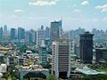
Denpasar has undergone massive unplanned development during the 21st century, due to the expansion of tourism leading to the construction of increasingly more modern facilities in the heart of the city. Nonetheless, the market square still plays an important role, with its façade representing traditional elements of the Balinese culture.
Tourism[]

Denpasar has various attractions. The white sandy beaches are well-known all over the island. The surfing beach is Serangan Island. Sanur beach has calmer waters and is excellent for sunbathing and kitesurfing.
Ten minutes from the Ngurah Rai International Airport lies the town of Kuta (within Badung Regency not administratively under the city jurisdiction), where most of the hotels, restaurants, malls, cafes, marketplaces, and spas that cater to tourists are located. In the Denpasar area, all kinds of Balinese handicrafts are represented in local shops. These include artwork, pottery, textiles, and silver. Batik cloth is sold all over Denpasar, and batik sarongs and men's shirts are widely available.
Education[]
This section needs expansion. You can help by . (April 2015) |
Denpasar has several notable universities and institutions. Some of them are
- Udayana University
- Warmadewa University
- University of National Education
- Dwijendra University
- Mahasaraswati University of Denpasar
- Indonesian Institute of the Arts, Denpasar
Transportation[]
Air[]

The city is served by Ngurah Rai International Airport, one of the busiest in Indonesia.[21]
Sea[]
Benoa Harbour is the entrance to the Denpasar by sea and is currently managed by PT Pelindo III.[22] The port is located about 10 km from the city center, and has been operating since 1924.
Land[]
Public transport in Denpasar, especially for urban transportation, is becoming ineffective and inefficient,[23] with only 30% of vehicles still in operation as of 2010. Public transport is not popular, and is used by only about 3% of the total population.[24] Meanwhile, the growth of private vehicle ownership is at 11% per year[citation needed] and is not comparable with the construction of new roads. Congestion in the city of Denpasar is unavoidable due to this reason.
Since August 2011, the city has operated a bus rapid transit system called Trans Sarbagita. Two main routes and some feeder lines are operated daily from 5 a.m. until 9 p.m. There is no dedicated lane for the buses: they run on main streets. In 2012 an average of 2,800 passengers per day used the service.[25]
Two major improvements to the road system were completed in 2013. In August, the underpass at the Dewa Ruci intersection was opened. It is slightly beyond the bounds of Denpasar but was co-financed by the town because of the expected positive effects on traffic in Denpasar.[26]
Then the four-lane Bali Mandara Toll Road was opened on 1 October, connecting Benoa Harbor, Ngurah Rai Airport, and Nusa Dua.
Sport[]
Denpasar has hosted numerous international and national sporting events. Denpasar was the venue for 2008 Asian Beach Games in Bali. Denpasar also held 2009 Asian Archery Championships.
In football, Denpasar is home to the football club Perseden Denpasar,[27] which plays in the Liga Nusantara.
Culture and sights[]
While arts and culture in Denpasar are largely synonymous with that of Hindu art and culture, there has also been a high level of interaction with other cultures that accompanied the arrival of visitors from all walks of life. Traditional values inspired by Hindu religious rituals still strongly influence the city.[28]
Traditional Balinese culture is still deeply rooted in Denpasar. It may include values, norms and behavior in society based on patrilineal kinship systems. However, over time many of the customary laws have been disputed by people, especially regarding matters of gender and inheritance.[29]
Denpasar has various sights to offer:
- Pura Jagatnatha is the most important Hindu temple of Denpasar. It was built in 1953.[30]
- Puri Pemecutan is the former royal palace of Denpasar, which was destroyed in a fire during the Dutch intervention in Bali (1906).[31] The palace was rebuilt in a comparatively modest style and can be visited.
- Pura Maospahit is a Hindu temple which was built in the 14th century and heavily damaged by the 1917 Bali earthquake and rebuilt afterwards.[32] The temple houses two impressive statues of Garuda and Batara Bayu, a mystic giant.
- St. Joseph Church is a Roman Catholic church built in a Hindu style.
- Denpasar City Tour [1] There's no better way to take a deep dive into the rich cultural heritage of Bali, both historical and contemporary, than via this exploration of the island's most-populous city.
- Bajra Sandhi Monument [2]is a major landmark in Denpasar, set right in the centre of the Renon Square (otherwise locally referred to simply as, 'Puputan Renon'). The site is adjacent the Bali Governor's office, and is hard to miss with its grand structure that resembles a Balinese Hindu priest's praying bell, or 'bajra'. Inside the base is a museum that displays various historical dioramas of the people's past struggle for ndependence.
Museums[]
The Bali Museum features Balinese art and history. The museum is built in the traditional Balinese style. There are four main buildings inside the museum, each with their own unique specialization of exhibits.[33]

Balinese ritual

Bali Museum, inside courtyards and gates, seen from the belvedere
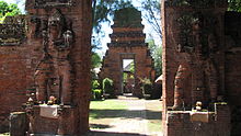
Hindu temple Pura Maospahit
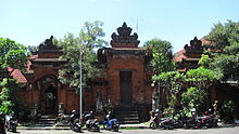
Puri Pemecutan Palace
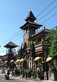
Saint Joseph's Roman Catholic Church


Sister cities[]
This section needs additional citations for verification. (December 2020) |
Denpasar is twinned with:
 Palembang, Indonesia
 Veracruz, Veracruz, Mexico
 Gran Canaria, Spain
 Phuket, Thailand
 Haikou, China PR[34]
 George Town, Malaysia
See also[]
- Bali Museum
- Denpasar International Airport
- List of twin towns and sister cities in Indonesia
References[]
- ^ Jump up to: a b c "BPS Provinsi Bali". Archived from the original on 1 January 2014. Retrieved 1 January 2014.
- ^ "Denpasar in Figures 2017". Badan Pusta Statistik Denpasar. Retrieved 30 June 2018.
- ^ Aris Ananta; Evi Nurvidya Arifin; M. Sairi Hasbullah; Nur Budi Handayani; dan Agus Pramono (2015). Demography of Indonesia's Ethnicity. Institute of Southeast Asian Studies dan BPS – Statistics Indonesia.
- ^ "Peta Sebaran Penduduk Menurut Suku Bangsa Provinsi Bali 2000 dan 2010" (in Indonesian) Retrieved 14 July 2018
- ^ Jump up to: a b "Kota Denpasar Dalam Angka 2020". www.denpasarkota.bps.go.id. Badan Pusat Statistik. Retrieved 20 Februari 2021. Check date values in:
|accessdate=(help) - ^ "Gambaran Umum Kota Denpasar dan Pemertahanan Bahasa Bali" (PDF). Archived from the original (PDF) on 20 May 2013. Retrieved 25 January 2013.
- ^ Achmadi, Amanda (2010). "Reading urban Bali: Untold history, unwanted urbanism". RIMA: Review of Indonesian and Malaysian Affairs. 44 (2): 156. ISSN 0815-7251.
- ^ "Bali History from 1846 to 1949 – Bali Historical Guide, The Dutch Occupation in Bali". Retrieved 25 January 2013.
- ^ Jump up to: a b c d e "Sejarah Kota Denpasar". Retrieved 25 January 2013.
- ^ I.B. Kade Sugirawan, Kondisi Ekologi Perairan Muara Sungai Badung di Teluk Benoa Ditinjau dari Parameter Fisika, Kimia, dan Biologi, Skripsi, Institut Pertanian Bogor, 1992.
- ^ "Denpasar, Indonesia Travel Weather Averages (Weatherbase)". Weatherbase. Retrieved 15 April 2020.
- ^ "Total Hours of Sunshine - Denpasar - Climate Robot Indonesia". www.weatheronline.co.uk. Retrieved 15 April 2020.
- ^ "Penduduk Bali 2015"[permanent dead link]
- ^ Djojosoekarto, A., Siahaan, H.M.P., Setiyawati, N.H., (2008), Pelayanan publik dalam persepsi masyarakat: hasil survei persepsi masyarakat dengan metode citizen report card di daerah, Kemitraan Partnership, ISBN 979-26-9631-8
- ^ Biro Pusat Statistik, Jakarta, 2011.
- ^ "Kerja Sama Kunci Terwujudnya Perpres Rencana Tata Ruang Kawasan Perkotaan". BKPRN. Archived from the original on 1 July 2013. Retrieved 25 January 2013.
- ^ "Motivasi Kerja Perempuan Bali pada Hotel Berbintang di Kota Denpasar" (PDF). LIPI. Archived from the original (PDF) on 11 January 2012. Retrieved 6 April 2011.
- ^ Achmadi, Amanda (2010). "Reading urban Bali: Untold history, unwanted urbanism". RIMA: Review of Indonesian and Malaysian Affairs. 44 (2): 149–178. ISSN 0815-7251.
- ^ Achmadi, Amanda (2010). "Reading urban Bali: Untold history, unwanted urbanism". RIMA: Review of Indonesian and Malaysian Affairs. 44 (2): 157–158. ISSN 0815-7251.
- ^ Achmadi, Amanda (2010). "Reading urban Bali: Untold history, unwanted urbanism". RIMA: Review of Indonesian and Malaysian Affairs. 44 (2): 155. ISSN 0815-7251.
- ^ Anjaiah, Veeramalla. "Indian firm to manage Bali airport operations". The Jakarta Post. Retrieved 25 January 2013.
- ^ "Benoa – Bali". PT Pelabuhan Indonesia III (PERSERO). Archived from the original on 16 January 2013. Retrieved 25 January 2013.
- ^ Ni Nyoman Murniasih, Evaluasi Kinerja Pelayanan Aangkutan Kota Denpasar Ditinjau Dari Pihak Operator, Skripsi, Institut Teknologi Bandung, 2005
- ^ "Angkot di Denpasar Mati Suri". Bali Post. Archived from the original on 17 May 2013. Retrieved 25 January 2013.
- ^ "Trans Sarbagita buses claimed to ease traffic". TheJakartaPost. Archived from the original on 25 May 2013. Retrieved 21 March 2013.
- ^ "Dewa Ruci underpass officially opened". TheJakartaPost.com. Archived from the original on 18 August 2013. Retrieved 14 October 2013.
- ^ "Perseden Denpasar Tembus Babak Semifinal". KONI. Retrieved 25 January 2013.
- ^ Profil daerah kabupaten dan kota, Volume 2, Penerbit Buku Kompas, 2001, ISBN 979-709-054-X.
- ^ Mery Wanyi Rihi, Kedudukan Anak Angkat Menurut Hukum Waris Adat Bali (Studi Kasus Di Kelurahan Sesetan, Kecamatan Denpasar Selatan, Kota Denpasar dan Pengadilan Negeri Denpasar), Tesis, Universitas Diponegoro, 2006
- ^ Birgit Borowski. Bali and Lombok, p. 133. Ostfildern 2013
- ^ Birgit Borowski. Bali and Lombok, p. 137. Ostfildern 2013
- ^ Birgit Borowski. Bali and Lombok, p. 134. Ostfildern 2013
- ^ Bali and Lombok, pp. 62–62.
- ^ "International co-operation of Gdynia". Gdynia.pl. Archived from the original on 19 October 2016.
External links[]
 Definitions from Wiktionary
 Media from Wikimedia Commons
 News from Wikinews
 Quotations from Wikiquote
 Texts from Wikisource
 Textbooks from Wikibooks
 Travel guide from Wikivoyage
 Resources from Wikiversity
 Denpasar travel guide from Wikivoyage
- Official site
| show Articles Related to Denpasar |
|---|

| show Authority control |
|---|
- Denpasar
- Populated places in Bali
- Cities in Indonesia
- Provincial capitals in Indonesia
- 1788 establishments in Asia