Samarinda
Samarinda | |
|---|---|
| City of Samarinda Kota Samarinda | |
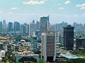
 From top, left to right: Grand Barumbay Resort, Official government building, Entrance of East Kalimantan main stadium, Lembuswana sculpture (Lembuswana is a legendary creature appearing in Kutai mythology of Samarinda), Catholic Archdiocese of Samarinda Building, Vihara Eka Dharma Manggala, and Samarinda Islamic Center Mosque. | |
 Coat of arms | |
| Motto(s): Samarinda Kota Tepian | |
| Anthem: "March of Kota Tepian" | |
 Location within East Kalimantan | |
 Samarinda Location in Kalimantan and Indonesia | |
| Coordinates: 0°29′59.874″S 117°8′15.9324″E / 0.49996500°S 117.137759000°ECoordinates: 0°29′59.874″S 117°8′15.9324″E / 0.49996500°S 117.137759000°E | |
| Country | Indonesia |
| Province | |
| Founded | 1668 |
| Government | |
| • Mayor | Andi Harun |
| Area | |
| • Total | 718.00 km2 (277 sq mi) |
| Elevation | 8 m (26 ft) |
| Population | |
| • Estimate (2020 Census) | 827,994 |
| • Rank | (19th) |
| • Density | 1,153/km2 (2,990/sq mi) |
| Demographics | |
| • Religion[2] | Islam 90.93% Christianity 5.25% Catholic 2.12% Buddhism 0.86% Hinduism 0.12% Confucianism 0.08% Others 0.01% |
| Time zone | UTC+8 (WITA) |
| Area code(s) | +62541 |
| Date format | dd-mm-yyyy |
| Drives on the | left |


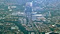
Samarinda is the capital city of the Indonesian province of East Kalimantan on the island of Borneo. The city lies on the banks of the Mahakam River with a land area of 718 km2 (277 sq mi). It is the most populous city on the entire Borneo island, with a population of 727,500 at the 2010 Census[3] and 827,994 at the 2020 Census.[4]
Although it is the capital of East Kalimantan, some government institutions such as the Regional Police and 6th Military Regional Command of Mulawarman headquarters are located in Balikpapan instead. Samarinda is known for its traditional food amplang, as well as the cloth sarung samarinda.[5] The city also has a bridge connecting its river banks, Mahakam Bridge. The city center is on one side and the other side is named Samarinda Seberang.
History[]
At the start of the Gowa War, the Dutch under Admiral Speelman's command attacked Makassar from the sea. Meanwhile, the Netherlands' Bugis ally Arung Palakka led a ground attack. The Kingdom of Gowa was forced to surrender and Sultan Hasanuddin was made to sign the Treaty of Bongaja on 19 November 1667.[6]
The treaty did not quell all trouble for the Dutch however, since the Bugis from Gowa continued their struggle using guerilla tactics. Some Buginese moved to other islands close by such as Kalimantan. A few thousand people led by Lamohang Daeng Mangkona or Pua Ado I, moved to East Kalimantan, known then as Kutai, where they were welcomed by the local Sultan.
Samarinda was a small, sleepy town in 1942 with several small oil fields in the vicinity. It was occupied by the Japanese after the Dutch East Indies had fallen.[7]
In 1955, the Apostolic Vicariate of Samarinda was established in the city. In 1961, it was promoted as the Diocese of Samarinda. In 2003, the diocese was promoted as the Metropolitan Archdiocese of Samarinda.[6]
Administrative districts[]
At the time of the 2010 Census, Samarinda City was divided into six districts (Indonesian: kecamatan), but four additional districts were subsequently created by splitting of existing ones. The ten districts are tabulated below with their areas and their populations at the 2010 Census[8] and the 2020 Census.[9]
| Name | Area in km2 |
Population Census 2010 |
Population Census 2020 |
|---|---|---|---|
| Palaran | 221.29 | 49,079 | 63,189 |
| Samarinda Ilir (Lower Samarinda) |
17.18 | 120,936 | 69,142 |
| Samarinda Kota (Samarinda town) |
11.12 | (a) | 31,719 |
| Sambutan | 100.95 | (a) | 57,941 |
| Samarinda Seberang | 12.49 | 114,183 | 64,050 |
| Loa Janan Ilir | 26.13 | (b) | 65,892 |
| Sungai Kunjang (Kunjang River) |
43.04 | 114,044 | 133,543 |
| Samarinda Ulu (Upper Samarinda) |
22.12 | 126,651 | 129,806 |
| Samarinda Utara (North Samarinda) |
229.52 | 202,607 | 106,743 |
| Sungai Pinang (Pinang River) |
34.16 | (c) | 105,970 |
| Totals | 718.00 | 727,500 | 827,994 |
Notes: (a) the 2010 populations of Samarinda Kota and Sambutan Districts are included in the 2010 figure for Samarinda Ilir District, from which they were later split off. (b) the 2010 population of Loa Janan Ilir District is included in the figure for Samarinda Seberang District, from which it was later split off. (c) the 2010 population of Sungai Pinang District is included in the figure for Samarinda Utara District, from which it was later split off.
Climate[]
Samarinda has a tropical rainforest climate (Köppen Af) with heavy rainfall and hot, oppressively humid temperatures year-round.
| hideClimate data for Samarinda | |||||||||||||
|---|---|---|---|---|---|---|---|---|---|---|---|---|---|
| Month | Jan | Feb | Mar | Apr | May | Jun | Jul | Aug | Sep | Oct | Nov | Dec | Year |
| Average high °C (°F) | 30.0 (86.0) |
30.3 (86.5) |
30.5 (86.9) |
30.5 (86.9) |
30.5 (86.9) |
29.9 (85.8) |
29.5 (85.1) |
29.9 (85.8) |
30.1 (86.2) |
30.8 (87.4) |
30.5 (86.9) |
30.4 (86.7) |
30.2 (86.4) |
| Daily mean °C (°F) | 26.5 (79.7) |
26.7 (80.1) |
26.8 (80.2) |
27.0 (80.6) |
27.2 (81.0) |
26.7 (80.1) |
26.3 (79.3) |
26.6 (79.9) |
26.8 (80.2) |
27.3 (81.1) |
26.9 (80.4) |
26.9 (80.4) |
26.8 (80.3) |
| Average low °C (°F) | 23.1 (73.6) |
23.1 (73.6) |
23.2 (73.8) |
23.5 (74.3) |
23.9 (75.0) |
23.6 (74.5) |
23.1 (73.6) |
23.4 (74.1) |
23.5 (74.3) |
23.8 (74.8) |
23.4 (74.1) |
23.4 (74.1) |
23.4 (74.1) |
| Average rainfall mm (inches) | 166 (6.5) |
173 (6.8) |
202 (8.0) |
236 (9.3) |
181 (7.1) |
168 (6.6) |
160 (6.3) |
148 (5.8) |
118 (4.6) |
145 (5.7) |
196 (7.7) |
209 (8.2) |
2,102 (82.6) |
| Source: [10] | |||||||||||||
Etymology[]
The name Samarinda originates from the description of the way in which the Bugis houses were constructed. At that time houses were customarily built on a raft and generally had the same height. This provided important social symbolism of equality between residents; no person's house, and thus no person, was seen as higher or lower than another. They named the settlement “Samarenda”, meaning “equally low”. After hundreds of years of use the pronunciation of the name changed slightly and the city became known as Samarinda.[11]
Economy[]
The economy of Samarinda is driven by the large amount of logging and oil extraction companies based there. Similar to Balikpapan, many national logging companies are based in Samarinda. There are many abandoned coal mines in Samarinda. Coal mining used to be very popular in Samarinda. However, the Indonesian government revoked many mining licenses due to the use of illegal chemicals and machinery. Due to all these economical activities in Samarinda, it is one of the richest cities in East Kalimantan.[citation needed]
Transport[]

Samarinda is connected by Trans-Kalimantan Highway Southern Route from Balikpapan to Samarinda; the highway runs in parallel with the first controlled-access expressway in Borneo, the Samarinda-Balikpapan Expressway, which is now under construction, and expected to be operational by the end of 2018.[12]
APT Pranoto (Samarinda Sungai Siring, AAP) International Airport is the primary airport for the city and has been at Sungai Siring since 2018. With over 1 million passengers annually, it is one of East Borneo's busiest airports in terms of passenger and cargo movements. AAP is an important Australian passenger gateway for East Borneo's wildlife. AAP was built to replace Temindung Airport in Bandara, Sungai Pinang.
The prominent coal loading port of Tanjung Bara (TBCT) lies about 160 kilometres to the north of Samarinda.[13]
Demographics[]
The territory's population in 2020 was 827,994 (422,624 male and 405,370 female), with an annual growth rate of 1.128% in 2019–2020.[14] The majority of the people of Samarinda are of Native Indonesian and Chinese descent. There are also Americans, Canadians, Japanese and Koreans working in Samarinda. Life expectancy in Samarinda was 73.6 years as of 2014.
Religion[]
Samarinda's main religions are Islam, Christianity and Buddhism. The Christian community of around 89,000 forms about 10.2% of the total population; Protestants form a larger number than Roman Catholics at a rate of 10:3. There are also Hindu communities.[citation needed]
References[]
Citations[]
- ^ updated to 2020 Census
- ^ Data Sensus Penduduk 2010 - Badan Pusat Statistik Republik Indonesia <http://sp2010.bps.go.id/index.php/site/tabel?tid=321&wid=6400000000&lang=id>
- ^ Statistics of Samarinda Municipality. 2018. Samarinda Dalam Angka 2018. Statistics of Samarinda Municipality, Samarinda.
- ^ Badan Pusat Statistik, Jakarta, 2021.
- ^ "Perhatikan 4 Hal Ini Saat Berburu Oleh-oleh Khas Samarinda". JalanTikus.
- ^ Jump up to: a b Ars, Moh (1986). Sejarah Kota Samarinda. Jakarta: Ministry of Education and Culture.
- ^ L, Klemen (1999–2000). "The conquest of Borneo Island, 1941-1942". Forgotten Campaign: The Dutch East Indies Campaign 1941-1942.
- ^ Biro Pusat Statistik, Jakarta, 2011.
- ^ Badan Pusat Statistik, Jakarta, 2021.
- ^ https://en.climate-data.org/location/46950
- ^ Dahlan, Oemar (1978). Asal-Usul Nama Samarinda Sejak Zaman sebelum Kemerdekaan, Nama Ini Sudah Terkenal di Seluruh Indonesia. Jakarta: Ministry of Education and Culture.
- ^ North Kalimantan Province Road Map - by the Road Preservation Directorate, Ministry of Public Works and Public Housing, Indonesia.
- ^ Admiralty sailing directions - Indonesia (10th ed.). Taunton: UK Hydrographic office. 15 July 2015.
- ^ Badan Pusat Statistik, Jakarta, 2021.
Sources[]
- L, Klemen (1999–2000). "Forgotten Campaign: The Dutch East Indies Campaign 1941-1942".
External links[]
 Definitions from Wiktionary
 Media from Wikimedia Commons
 News from Wikinews
 Quotations from Wikiquote
 Texts from Wikisource
 Textbooks from Wikibooks
 Travel guides from Wikivoyage
 Resources from Wikiversity
 Data from Wikidata
- GovSamarinda Samarinda Government portal
| show Places adjacent to Samarinda |
|---|
| show Regencies and cities of East Kalimantan |
|---|
| show Articles Related to Samarinda |
|---|

| show Authority control |
|---|
- Samarinda
- Provincial capitals in Indonesia
- Populated places in East Kalimantan