Banjarmasin
Banjarmasin | |
|---|---|
| Other transcription(s) | |
| • Jawi | بنجر ماسين |
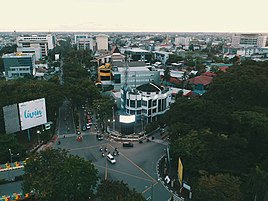
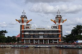
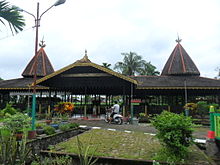
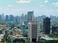
Clockwise from top: Banjarmasin seen from above, Soetji Nurani Chinese Temple, Banjarmasin watchtower, and Banjarmasin floating market. | |
 Flag  Coat of arms | |
| Nicknames: Kota Seribu Sungai (Indonesian: City of Thousand Rivers)
[1] | |
| Motto(s): | |
 Interactive map outlining Banjarmasin | |
 Location within South Kalimantan Province | |
 Banjarmasin Location within Kalimantan | |
| Coordinates: 3°20′S 114°35′E / 3.333°S 114.583°ECoordinates: 3°20′S 114°35′E / 3.333°S 114.583°E | |
| Country | Indonesia |
| Province | South Kalimantan |
| Established | 24 September 1526 |
| Government | |
| • Mayor | Ibnu Sina |
| • Vice Mayor | Hermansyah |
| Area | |
| • City | 98.46 km2 (38.02 sq mi) |
| • Metro | 3,404.46 km2 (1,314.47 sq mi) |
| Elevation | 1 m (3 ft) |
| Population (2020) | |
| • City | 657,663 |
| • Density | 6,700/km2 (17,000/sq mi) |
| • Metro | 2,184,427 |
| • Metro density | 640/km2 (1,700/sq mi) |
| Time zone | UTC+8 (WITA) |
| Area code(s) | +62 511 |
| HDI (2019) | |
| Website | banjarmasinkota |


Banjarmasin is a city and the capital of South Kalimantan, Indonesia. It is located on a delta island near the junction of the Barito and Martapura rivers. Historically the center of Banjarese culture and the capital of the Sultanate of Banjar, it is the biggest city in South Kalimantan and one of main cities of Kalimantan. The city covers an area of 98.46 square kilometres (38.02 sq mi) and had an estimated population of 657,663 in 2020. , also known as Banjarbakula, is an urban agglomeration of around two million people covering an area of 8,136 square kilometres (3,141 sq mi), which includes Banjarbaru, parts of Banjar Regency, Barito Kuala Regency, and Tanah Laut Regency and accounts for almost half of the province's population. It is the third most populous city on the island of Borneo after Samarinda and Balikpapan, and the most populous officially recognized metropolitan area on the entire island with more than three times the population of Kuching metropolitan area, the second largest officially recognized metropolitan area in the island.[4][5][6][7]
It is the de jure seat of the South Kalimantan governor although some of provincial buildings have been relocated to Banjarbaru and also location of provincial parliament. It is the only officially recognized metropolitan area located in Kalimantan as of 2019.[8][9]
History[]
Negara Dipa (1380-1478)
Negara Daha (1478-1520)Banjar Sultanate (1520-1526)
Demak Sultanate (1526-1546)VOC (1635–1638)
England (1701—1707)
Dutch Republic (1787–1795)
Batavian Republic (1795–1806)
Dutch East Indies (1806–1809)
Kingdom of Great Britain and Ireland (1815–1816)
Empire of Japan (1942–1945)
Indonesia (1949–today)
Etymology[]
It is thought that the name "Banjarmasin" is a corrupted version of "Bandar Masih" (Port Masih). "Masih" originates from the Ngaju language. Oloh Masi refers to the coastal dwelling Malay population. There is speculation that Patih Masih, who ruled the port and the surrounding villages, was not a real name but instead a nickname. This was used by the population from the region, specifically the Dayaks who lived in the interior and visited the port regularly to trade. Some even eventually settled in the port. They eventually contributed to the culture of the Banjar people whose culture is a mixture of Javanese, Malay, and Dayak cultures.[10][11]
Early history[]
European archeologist H. Kupper discovered several prehistoric sites around the region in 1939 and found implements such as choppers and other stone tools. Most of the artifacts found around the region and the province show signs of Neolithic culture. Migration from mainland Asia to Borneo may have been common when they were connected by the Sunda Shelf. Many stone tools were found in Awang Bangkal, 50 kilometres (31 mi) from the city.[10]
Until the early 15th century, there were few written records found from the region. Outside records indicate it was home to several kingdoms such as Tanjungpuri, which was theorized to have been founded by Malay people from Srivijaya, and Negara Daha and Dipa founded by Javanese from Majapahit. Hinduism and Buddhism entered the region between the first and 15th centuries. There are two candi (temple) left in the region; Candi Laras and Candi Agung.[12] There is also a native kingdom, which was thought to be the oldest kingdom in the entire archipelago, Nan Sarunai, founded by the Ma'anyan people. This kingdom was believed to be exist based on a Ma'anyan folk song called "Usak Jawa", which was thought to tell the story of the Majapahit conquest of the kingdom, and several carved stone tombs. However, the existence of this kingdom is disputed.[13][10][14]
The history of Banjarmasin as a place generally began during the founding of the Sultanate of Banjar. According to folk stories and the Hikayat Banjar, Sukarama, the fourth king of Negara Daha, wanted his grandson, Raden Samudra, to be his successor in the kingdom instead of his direct son Prince Tumenggung. Prince Tumenggung later banished Raden Samudra and tried to reclaim the throne for himself. Raden Samudra fled to the region that would later be known as Banjarmasin. From there, he met Patih Masih, who controlled a port in the region. Under Samudra's leadership, the port grew into a town which would be called Bandar Masih ('Port Masih').[15][10] Tumenggung, who disliked Samudra's growing power, wanted to invade the town. To defend himself, Samudra allied with the Demak Sultanate, which agreed to help him. In return he would have to convert to Islam if he won. With the help of expeditionary forces from Demak, Samudra defeated the Tumenggung forces and proclaimed the Banjar Sultanate. He changed his name to Sultan Suriansyah I. The sultanate became more reliant on the Demak to the point it was considered their protectorate. However, between 1546 and 1550, as conquests and the spice trade enriched the sultanate, it became independent and stopped sending tributes to Java.[10][16]
Colonial era[]

The first contact between Europeans and the Banjar people in the region came through trade Since 1596, this mostly took place in Banten. European traders, largely Dutch, did not bother visiting the port until they were banned from Banten by its local rulers. As the result, these traders resorted to attacking ships from other countries, including ships under the Banjar Sultanate, to steal nutmeg. This did not impress the sultan, who later took revenge against a Dutch ship visiting Banjarmasin on 17 July 1607 by hijacking it and massacring the crew. This hijacking and killing happened several times between 1603 and 1636. It ceased when trade agreements were reached, which put the Dutch East India Company in control of the nutmeg trade from the sultanate and gave it a monopoly over trade in Banjarmasin. The company was expelled in 1638, however, after the sultan waged a war against the Dutch and burned much of the company's possessions around the port.[17][10]

Like the Dutch, an English company was expelled from the region in 1707 after a treaty had been agreed upon in 1698. The region was under British control after the Napoleonic Wars, but was ceded to the Dutch East Indies Company under the Treaty of London.[10][16] A succession crisis between Sultan Adam and Tamjidillah II, coupled with a dispute over resource control of coal mines, for example, resulted in a war between the sultanate and the Dutch East Indies Company which abolished the sultanate in 1863. The war continued until 1905 under an emergency government set up by the sultanate called Pagustian. The last resistance was put down with the capture of Queen Zaleha in 1906.[16][18] The war also resulted in the migration of Banjar people from Borneo who formed communities in Sumatra, Singapore, and Malaysia.[18]
20th century–present[]

When World War II broke out, the city was occupied by Japanese forces under the Imperial Japanese Army. After the Battle of Banjarmasin, control was transferred to the Imperial Japanese Navy. Locals described Japanese rule under the navy as harsher compared to the army. This led many people to escape to Java, which remained under army rule. The city was liberated by Australian forces in September 1945. The return of Dutch rule, however, was opposed by the people and resulted in four years of war between Indonesian nationalists and the Royal Netherlands East Indies Army. This ended with the Dutch recognition of Indonesia in 1949. The city was briefly assigned as the capital of Great Dayak federal state before being absorbed into a single Kalimantan province. It later became the capital city of the newly formed South Kalimantan province.[10][19][20] However, because of frequent flooding, there was a plan to relocate the provincial capital city to Banjarbaru. This did not fully materialize until recently.[21] It was granted city status by Indonesian government in 1959 based on Law Number 27 of 1959.[4]
On 23 May 1997, the city witnessed a riot caused by friction between supporters of the United Development Party and Golkar. The riot later developed into looting, which targeted Chinese and Christian minorities and several shopping malls.[22][23][24] The riot today is known by locals as Jumat Kelabu or Grey Friday.[25]
Geography[]
Banjarmasin is located on Barito basin and divided by the Martapura River into two parts. Slope of the city is 0.13% and the land is generally flat and low lying. The geological foundation of the city is dominated by clay and sandstone, but also includes alluvial sediments from the river. Several smaller rivers exist which form a dendritic drainage pattern. All the smaller rivers are connected to either the Martapura River or Barito River. The city's river system is affected by tides. The city is located in a swampy region and is generally below sea water level, making it prone to being flooded by tidal waves.[26][9]
The area of city proper is 98.46 square kilometres (38.02 sq mi), or around 0.26% of the provincial area.[9] It borders the Barito Kuala Regency in the north and west and the Banjar Regency in the east and south.[9]
Climate[]
Banjarmasin has a tropical savanna climate (Aw) with heavy rainfall from November to June and moderate rainfall from July to October. The monthly temperature is within range between 26 °C (79 °F) to 38 °C (100 °F) with an average maximum temperature of 33 °C (91 °F) and average minimum temperature of 22 °C (72 °F). However, there is a slight variation of seasonal temperatures because of the monsoon. Precipitation can reach between 2,400 millimetres (94 in) and 3,500 millimetres (140 in) yearly, however, its average average is 1,600 millimetres (63 in). The hottest months are between March and September when the temperature can reach an average as high as 36 °C (97 °F). Annual sunshine during rainy season is 2.8 hours per day and 6.5 hours during dry season.[9][26]
Air humidity sits between 75 and 90% on January, which is the wettest month and 52% on September which is the driest month.[26]
| Climate data for Banjarmasin | |||||||||||||
|---|---|---|---|---|---|---|---|---|---|---|---|---|---|
| Month | Jan | Feb | Mar | Apr | May | Jun | Jul | Aug | Sep | Oct | Nov | Dec | Year |
| Average high °C (°F) | 29.2 (84.6) |
30.0 (86.0) |
30.3 (86.5) |
31.1 (88.0) |
31.1 (88.0) |
30.9 (87.6) |
31.5 (88.7) |
32.3 (90.1) |
32.6 (90.7) |
32.2 (90.0) |
31.1 (88.0) |
30.2 (86.4) |
31.0 (87.9) |
| Daily mean °C (°F) | 25.7 (78.3) |
26.3 (79.3) |
26.4 (79.5) |
27.0 (80.6) |
26.9 (80.4) |
26.4 (79.5) |
26.7 (80.1) |
27.2 (81.0) |
27.4 (81.3) |
27.2 (81.0) |
26.8 (80.2) |
26.4 (79.5) |
26.7 (80.1) |
| Average low °C (°F) | 22.2 (72.0) |
22.6 (72.7) |
22.6 (72.7) |
22.9 (73.2) |
22.8 (73.0) |
22.0 (71.6) |
21.9 (71.4) |
22.1 (71.8) |
22.3 (72.1) |
22.3 (72.1) |
22.5 (72.5) |
22.7 (72.9) |
22.4 (72.3) |
| Average precipitation mm (inches) | 327 (12.9) |
302 (11.9) |
300 (11.8) |
220 (8.7) |
168 (6.6) |
141 (5.6) |
98 (3.9) |
86 (3.4) |
103 (4.1) |
133 (5.2) |
226 (8.9) |
311 (12.2) |
2,415 (95.2) |
| Source: [27] | |||||||||||||
Governance[]

Administrative division[]
The city is divided into five districts (kecamatan). The most densely populated district is Central Banjarmasin with density of 13,155 per square kilometers while the least densely populated district is South Banjarmasin with density of 4,281 per square kilometers. As of 2020, South, North, and East Banjarmasin district experienced population growth of both South and North with 1.10% and East Banjarmasin with 0.58% while Central and West Banjarmasin both experienced decline of 0.46%. Below is the list of districts and its population figure as of 2020.[9]
- South Banjarmasin (163,948)
- North Banjarmasin (150,883)
- East Banjarmasin (118,389)
- West Banjarmasin (136,964)
- Central Banjarmasin (87,479)
Local government[]
As with all Indonesian cities, it is a second-level administrative division run by a mayor and a vice mayor together with the city parliament, and it is equivalent to a regency.[28] Executive power is vested in the mayor and vice mayor, while legislative duties are vested in the local parliament. The mayor, vice mayor, and parliament members are directly elected by the people of the city in an election.[29] Heads of districts are appointed by the mayor on the recommendation of the city secretary.[30][31]
Politics[]
On provincial level, the city is part of 1st electoral district of South Kalimantan, which have 8 out of 55 representatives. On city level, the city is divided into five electoral districts that in total, the city parliament has 45 representatives. The last election was in 2019 and the next one is scheduled for 2024.[32]
| Electoral district | Region | Representatives |
|---|---|---|
| Banjarmasin 1st | Central Banjarmasin District | 6 |
| Banjarmasin 2nd | North Banjarmasin District | 10 |
| Banjarmasin 3rd | East Banjarmasin District | 8 |
| Banjarmasin 4th | South Banjarmasin District | 11 |
| Banjarmasin 5th | West Banjarmasin District | 10 |
| Total | 45 | |
Economy[]

The city's economy is dominated by manufacturing, which accounts for 17.19% of its gross regional product (GRP) as of 2020. The second largest sector is trade, which accounts for 12.57% of the city's GRP, followed by the finance sector with at 12.29% in 2020. The agriculture sector is small contributing only 2.43% of city's GRP. Mining is nonexistent within the city, in stark contrast to neighbouring regions. In 2019, economic growth was 6.38%. However, in 2020 there was an economic downturn caused by the COVID-19 pandemic, resulting in a decrease of 1.91%. The city imports 1,900,000 long tons (1,900,000 t) of goods through the city's main port, the Port of Trisakti, and exports 98,320,000 long tons (99,900,000 t) of goods as of 2019. Goods movement increased 92.24% between 2018 and 2019. The city experienced 4.15% yearly inflation on 2019.[33][9]
Industry[]
Around 62% of industry in the city is focused on food and drink processing and its related products. This includes bread, flour, and soybean sauce production. Other industries include rubber and plastic, which accounts for about 15% of the city's industrial output. The rest of its industrial output is from machinery, pharmaceutical, paper products, and electrical equipment.[34]
There are 3,014 industrial companies registered in the city as of 2020 that employ 22,063 people. Smaller scale industries producing wood furniture, clothing, and snacks also exist in the city with 88 registered smaller scale businesses in this sector in 2020.[9]
Tourism[]
The city has 129 hotels registered as of 2020. The city was visited by 109,653 domestic tourists and 251 foreign tourists. According to Statistics Indonesia, in 2020 there were 113 identified potential tourist spots in the city. Tourism, however, remains small sector in the city's economy.[9]
Finance[]
Finance sector in general has been growing steadily in the past five years, with an annual growth of around 3%. 67% of this sector is basic financial services, followed by pension funds and insurance services with 14.94%. The city accounts for 67.61% of financial activities in the entire province, both in local and foreign currencies.[33]
Demographics[]

According to Statistics Indonesia, a resident of the city is defined as "someone who resides within the city for at least 6 months or less than 6 months but with intention to settle". The estimated number of residents in 2020 was 657,663 with a sex ratio of 100.36. 47.87% of the city population resides in the South and North Banjarmasin districts. As with most of Indonesian cities, the population is young and consists of a workforce within the reproductive age of above 15, which in the city is around 62.07% of the city's population in 2020, or 331,526 people. Annual population growth was 0.44% between 2010 and 2020. East and Central Banjarmasin district. however, has a sex ratio of 98.84 and 97.47 respectively, which means both districts have more female residents than males. This differs from the city average. The city's dominant religion is Islam, with a minority of Protestants, Catholics, Hindus, Buddhists, Confucianists, and animist religions. Muslims make up around 95% of the city's population, followed by Christians (both Catholics and Protestants) at around 3%; other religions combined total about 2%.[9]
Most of the city's population identifies as Banjarese—79,26% did so in 2010. Other ethnicities include Javanese with 10.27%, Madurese with 3.17%, Chinese Indonesian with 1.56%, Dayak with 0.92%, and Bugis with 0.6%.[35] There is also a population of Arabs in the city that date back to Sultanate and colonial era.[35]
Education[]
The literacy rate in 2020 was 98.94%. There are 311 kindergartens, 208 elementary schools, 35 junior high schools, and 29 senior high schools as of 2020. There are also 22 vocational high schools in the city. The city is home to more than 25 higher education institutions and universities. One of the most notable, which is also a public university, is the Lambung Mangkurat University. The university has more than 2,000 graduates every year—most of them from teaching and science education. The second favourite major in 2020 was economics and business, followed by engineering, agricultural science, and medical subjects. In 2020, there were 700 postgraduate students. A developed education system and the existence of educational institutions attract students from neighbouring regions to pursue their education in the city.[36][9] Other notable private universities, such as the Muhammad Arsyad Al-Banjari Kalimantan Islamic University, have the greatest number of students. According to Indonesian Statistics, in 2020 there 11,854 male and 8,189 female students. The school participation rate was 97.91% as of 2020.[9][37]
Healthcare[]

The city has eight hospitals and 34 polyclinics as of 2020. There are also 26 puskesmas (community healthcare centres), 26 healthcare centers, and 47 pharmacies. The main and largest hospital in the city is Ulin Regional Hospital, which is owned by the provincial government. It is classified as an A-type hospital by the Ministry of Health. Life expectancy in the city as of 2020 was 71.13 years, which is significantly above the provincial average.[38][9]
As of 2020, 511,118 people of the total city population of 657,663 is registered in the BPJS Kesehatan, government-mandated social insurance, which covers certain healthcare costs.[9] 89% of newborn babies in 2020 were vaccinated with basic vaccines such as polio vaccine, MMR vaccine, and Hepatitis B vaccine. Around 95% of newborn babies are born inside a healthcare or maternity facility, while 99.98% of births are assisted by healthcare workers.[37]
Culture and entertainment[]
Banjarese culture[]

The city's dominant culture is that of the Banjar people, which have characteristics described as those of a "river culture" and are influenced by other ethnicities such as Dayak, Javanese, Malay, Arab, and even Persian. Despite being a Muslim majority, the Banjar people still hold on to the importance of cultural parts that have been influenced by their Hindu-Buddhist past. This includes the Malanuh ceremony, which is an offering to supernatural beings.[39] One annual event that is celebrated widely by the people of the city is Haul Guru Sekumpul, an event commemorating the death of a charismatic ulema from the region, Zaini Abdul Ghani.[40][41]
Another famous cultural sight in the city is a floating market located on the Kuin River and Lok Baintan. People meet on the river after Fajr prayer until around 07:00 pm and transactions with the merchants are done from small boats. Small snacks, vegetables, fruits, meat, and many other groceries are sold at the market. This market is dying, however, and the number of merchants has declined because of the shift from river culture to land culture and competition with regular land markets.[42] The city is home to a cultural center building surrounded by a cultural park where traditional artists can often be seen performing. The building and its surrounding has been used regularly to hold cultural events to preserve Banjarese culture, as well as to facilitate local artists.[43][44][45]
City parks[]

There are several city parks and public spaces in the city, one of the most notable being Siring Park, located in the center of the city. Sometimes referred to by locals as "0 Kilometer Park", the park is located on the shores of the Martapura River and also acts as a waterfront for the river with docks for small boats in the river. Facilities in the park include a watchtower, several gazebos, pedestrian roads, and skateboard parks. In front of the park, there is an urban bus stop used by both Trans Banjarmasin & BRT Banjarbakula bus companies.[46] In addition, the park includes one of the city's landmarks, a 6.5 metres (21 ft) statue of a bekantan (Proboscis monkey) which is a native primate in the region. The park is also a center for street foods in the city during dusk.[47][48][49]
Other city parks include Kamboja Park, Bungas Banjarmasin Park, and Banua Anyar Public Space. Located 2 kilometres (1.2 mi) from the city center, Banua Anyar Public Space is specifically designed for toddlers and kids. It is located below Banua Anyar bridge and has facilities such as a kids' park, artificial soft grass to ensure child safety, and book reading corners.[50][51][52][53]
Others[]

Several shopping malls are located in the city. The Duta Mall Banjarmasin is the largest in the province, and connected to a hotel called The Mercure Hotel. Located in Central Banjarmasin district, it occupies more than 42,000 square metres (450,000 sq ft) and consists of four stories. It is also surrounded by several other buildings housing stores, forming a complex with a total area of 80,000 square metres (860,000 sq ft).[54][55] Other entertainment centers in the city include Trans Studio Mini Banjarmasin, an indoor theme park which is owned by Trans Corp and malls such as Mitra Plaza, Lotte Mart, and Giant.[56] Mitra Plaza is one of the city's oldest modern shopping centers, and was a target of looting and destruction during the Banjarmasin riot of May 1997. It was renovated after the riot.[57] Other than modern shopping malls, according to Statistics Indonesia, as of 2019, there are 60 traditional markets registered in the city.[58]
Transportation[]

The city has 790.13 kilometres (490.96 mi) of road, most of which have been paved with asphalt. It is connected to the Trans-Kalimantan Highway Southern Route, which connects it to other big cities such as Palangka Raya and Samarinda.[59] Kilometer 6 Bus Terminal is the main bus terminal for the city and the province, where buses for long inter-province routes gather.[60] Being old and overcrowded, the government relocated the main terminal to the newly built Kilometer 17 Bus Terminal in Gambut District, Banjar Regency. However, the new terminal is rarely used and many bus operators resisted the relocation because of the remoteness of the new terminal from the city center.[61]
Being divided by a big navigable river, speed boats on the river are also an important means of transportation within the city. Ride-hailing services such as Gojek and Grab are widespread. The city has two urban bus services, BRT Banjarbakula which connects it to the Greater Banjarmasin area and , which only serves the city proper.[62][63][64] As with other Indonesian cities, the city has angkots (shared taxis), which have been declining rapidly because of competition from online ride-hailing services, online taxis, and new public transportation services created by the city government.[65][66]
The city is served by the Port of Trisakti, which is one of main ports in Indonesia and classified as class IA. The port has a passenger terminal for passenger ships to neighbouring islands such as Java and Sulawesi.[67][68] The closest airport is the Syamsudin Noor International Airport, which located inside Banjarbaru city, 29 kilometres (18 mi) from Banjarmasin.[69]
Media[]

There are numerous newspapers, television stations, and radio based in Banjarmasin. The city is center of mass media in the province of South Kalimantan. Known established media groups such as Banjarmasin Post, Kalimantan Post, and Radar Banjarmasin existed since early New Order period, while numerous smaller independent media were founded mostly after Reformasi. Other example of news media are Barito Post, Mata Banua, Metro Banjar, and Kanal Kalimantan. In total, there were 47 registered news media including printed and online, 36 tabloids, and 4 magazines in the city.[70]
In television sector, outside of nationwide networks both private and state-owned, there are local television stations focused mostly on local news. State-owned television network TVRI has local branch for South Kalimantan located in Banjarmasin, while Duta TV and Banjar TV, two most prominent local channels, are private.[71][72][73][74]
Other than that, the city is also has branch of Radio Republik Indonesia, Indonesian state-owned radio network.[75] There are 24 formally registered radio stations, although the number could be higher.[74]
References[]
- ^ "Tagline Baru dan Pasar Terapung". Banjarmasin Post (in Indonesian). Archived from the original on 28 June 2021. Retrieved 28 June 2021.
- ^ zagitanank. "Post - Walikota Narasumber APIP di Inspektorat Kota". Website Berita Banjarmasin (in Indonesian). Archived from the original on 31 August 2021. Retrieved 28 June 2021.
- ^ "Indeks Pembangunan Manusia Kota Banjarmasin, Badan Pusat Statistik, 2018". Archived from the original on 25 December 2018. Retrieved 25 December 2018.
- ^ a b "Profil Kota Banjarmasin | BPK RI Perwakilan Provinsi Kalimantan Selatan". Archived from the original on 8 May 2021. Retrieved 8 May 2021.
- ^ Omed, Kata (25 May 2020). "Daftar 10 Kota Besar di Kalimantan". KATA OMED. Archived from the original on 1 November 2020. Retrieved 21 May 2021.
- ^ "Kuching, Malaysia Metro Area Population 1950-2021". www.macrotrends.net. Archived from the original on 28 February 2021. Retrieved 21 May 2021.
- ^ "Greater Kota Kinabalu Healthcare Overview" (PDF). Sabah Economic Development and Investment Authority. Archived (PDF) from the original on 13 May 2013. Retrieved 19 April 2012.
- ^ "PU-net". perkotaan.bpiw.pu.go.id. Archived from the original on 10 May 2021. Retrieved 8 May 2021.
- ^ a b c d e f g h i j k l m n "BPS Kota Banjarmasin". banjarmasinkota.bps.go.id. Archived from the original on 10 May 2021. Retrieved 8 May 2021.
- ^ a b c d e f g h Sejarah Daerah Kalimantan Selatan (History of South Kalimantan Region). Department of Education and Cultural Affairs (Indonesia). 1978.
- ^ "Asal Usul Nama Kota Banjarmasin dari Sosok Ini". Banjarmasin Post (in Indonesian). Archived from the original on 8 May 2021. Retrieved 8 May 2021.
- ^ bpcbkaltim (19 February 2020). "Usia Candi Laras". Balai Pelestarian Cagar Budaya Kalimantan Timur. Archived from the original on 8 May 2021. Retrieved 8 May 2021.
- ^ "The source of power of the Dayak Ma'anyan Tribes' political". Archived from the original on 10 May 2021. Retrieved 8 May 2021.
- ^ Raditya, Iswara N. "Jejak Panjang Nan Sarunai, Kerajaan Purba di Kalimantan". tirto.id (in Indonesian). Archived from the original on 8 May 2021. Retrieved 8 May 2021.
- ^ "Kerajaan Banjar: Sejarah, Pendiri, Masa Jaya dan Raja". VOI - Waktunya Merevolusi Pemberitaan (in Indonesian). Archived from the original on 10 May 2021. Retrieved 8 May 2021.
- ^ a b c Barjie B, Ahmad (2015). Perang Banjar Barito. Penakita Publisher. ISBN 9786021285558.
- ^ Noorlander, J.C. (1935). Banjarmasin en de Compagnie in de Tweede Helft der 18 de Eeuw. Leiden: N. Dubbeldeman. p. 5.
- ^ a b "Sejarah Kesultanan Dan Budaya Banjar" (PDF). Archived (PDF) from the original on 10 May 2021. Retrieved 8 May 2021.
- ^ Elson, Robert Edward (2009). The Idea of Indonesia (in Indonesian). Penerbit Serambi. ISBN 978-979-024-105-3. Archived from the original on 10 May 2021. Retrieved 8 May 2021.
- ^ Johnston, Mark (16 April 2000). Fighting the Enemy: Australian Soldiers and Their Adversaries in World War II. Cambridge University Press. ISBN 978-0-521-78222-7. Archived from the original on 8 May 2021. Retrieved 8 May 2021.
- ^ Aufa, Naimatul; Anhar, Pakhri (18 January 2016). "Studi Tata Ruang Kota Rancangan Van Der Pijl Kasus: Kota Banjarbar, Kalimantan Selatan". Tataloka. 14 (2): 142–155. doi:10.14710/tataloka.14.2.142-155 (inactive 31 October 2021). ISSN 2356-0266. Archived from the original on 10 May 2021. Retrieved 8 May 2021.CS1 maint: DOI inactive as of October 2021 (link)
- ^ "As Indonesia holds an election, a small town in Borneo burns". The Independent. 22 October 2011. Archived from the original on 8 December 2017. Retrieved 8 May 2021.
- ^ "The Nation". news.google.com. Archived from the original on 8 January 2021. Retrieved 8 May 2021.
- ^ Mydans, Seth (26 May 1997). "In Indonesia, A Deadly End To a Campaign". The New York Times. ISSN 0362-4331. Archived from the original on 28 December 2017. Retrieved 8 May 2021.
- ^ "Sejarah Hari Ini: 22 Tahun Lalu Ratusan Orang Meninggal akibat Tragedi Jumat Kelabu di Banjarmasin". Tribun Kaltim (in Indonesian). Archived from the original on 8 May 2021. Retrieved 8 May 2021.
- ^ a b c "Kondisi Umum Banjarmasin". docplayer.info. Archived from the original on 8 May 2021. Retrieved 8 May 2021.
- ^ "Banjarmasin climate: Average Temperature, weather by month, Banjarmasin weather averages - Climate-Data.org". en.climate-data.org. Archived from the original on 1 October 2019. Retrieved 22 May 2021.
- ^ "UU 22 1999" (PDF). Archived (PDF) from the original on 16 April 2021. Retrieved 8 May 2021.
- ^ "UU 8 2015" (PDF). Archived (PDF) from the original on 26 February 2021. Retrieved 8 May 2021.
- ^ "PP No. 17 Tahun 2018 tentang Kecamatan [JDIH BPK RI]". peraturan.bpk.go.id. Archived from the original on 17 April 2021. Retrieved 16 April 2021.
- ^ Government Law No.19 1998
- ^ "KepKPU Kalsel 285" (PDF). Archived (PDF) from the original on 10 December 2018. Retrieved 9 May 2021.
- ^ a b "BPS Kota Banjarmasin". banjarmasinkota.bps.go.id. Archived from the original on 9 May 2021. Retrieved 9 May 2021.
- ^ "BPS Kota Banjarmasin". banjarmasinkota.bps.go.id. Archived from the original on 9 May 2021. Retrieved 9 May 2021.
- ^ a b Profil dan Analisis Hasil Sensus Penduduk 2010 dan Proyeksi Penduduk 2010-2020 Kota Banjarmasin
- ^ Alamin, Rabul; Adyatma, Sidharta; Arisanty, Deasy (16 August 2016). "Faktor Yang Mempengaruhi Mobilitas Ulang Ulang Alike Penduduk Kecamatan Tamban Menuju Kota Banjarmasin". Jurnal Pendidikan Geografi. 2 (1). doi:10.20527/jpg.v2i1.1463 (inactive 31 October 2021). ISSN 2685-6395. Archived from the original on 31 August 2021. Retrieved 9 May 2021.CS1 maint: DOI inactive as of October 2021 (link)
- ^ a b "BPS Kota Banjarmasin". banjarmasinkota.bps.go.id. Archived from the original on 9 May 2021. Retrieved 9 May 2021.
- ^ "Rumah Sakit Umum Daerah Ulin". rsulin.kalselprov.go.id. Archived from the original on 9 May 2021. Retrieved 9 May 2021.
- ^ "Kota Banjarmasin". Kongres Kebudayaan Indonesia 2018 (in Indonesian). 3 December 2018. Archived from the original on 9 May 2021. Retrieved 9 May 2021.
- ^ klikkalimantan (3 February 2020). "2,5 Juta Jamaah Diperkirakan Hadir pada Haul ke-15 Guru Sekumpul". Klik Kalimantan (in Indonesian). Archived from the original on 5 May 2021. Retrieved 9 May 2021.
- ^ "Berbagai Persiapan Dilakukan Untuk Pelaksanaan Haul Guru Sekumpul". Pemerintah Kabupaten Banjar (in Indonesian). Archived from the original on 1 May 2021. Retrieved 9 May 2021.
- ^ "JPNN". www.jpnn.com (in Indonesian). 21 April 2010. Archived from the original on 9 May 2021. Retrieved 9 May 2021.
- ^ M. Gigih Tulus Pasaribu (2004). "Gedung Kesenian Pusat Pagelaran Lima Seni Budaya Banjar Banjarmasin Kalimantan Selatan". Archived from the original on 10 May 2021. Retrieved 9 May 2021. Cite journal requires
|journal=(help) - ^ "Taman Budaya Kalsel siapkan pergelaran dihari musik nasional 2021". ANTARA News Kalimantan Selatan. Antara News Agency. Archived from the original on 9 May 2021. Retrieved 9 May 2021.
- ^ "Taman Budaya, Tempatnya Menyaksikan Beragam Hiburan di Banjarmasin". Majalahteras.com. 8 June 2015. Archived from the original on 9 May 2021. Retrieved 9 May 2021.
- ^ "Sementara Gratis! Ini Rute Perlintasan Bus Trans Banjarmasin". Kanal Kalimantan (in Indonesian). 17 February 2020. Archived from the original on 12 December 2020. Retrieved 21 May 2021.
- ^ "Skater Banjarmasin Tak Mau Pakai Skateboard Park Siring, Ada Apa Ya?". Banjarmasin Post (in Indonesian). Archived from the original on 7 February 2021. Retrieved 21 May 2021.
- ^ "10 Taman di Banjarmasin yang Cocok untuk Refreshing - Borneo ID". 23 July 2020. Archived from the original on 31 August 2021. Retrieved 21 May 2021.
- ^ "Serunya Berkelana dengan Kapal di Siring Kota Banjarmasin". Traveling Yuk. 1 February 2020. Archived from the original on 31 August 2021. Retrieved 21 May 2021.
- ^ "Kalselpedia: Daftar Taman di Kota Banjarmasin, Tempat Bersantai Nan Nyaman". Banjarmasin Post (in Indonesian). Archived from the original on 24 August 2020. Retrieved 21 May 2021.
- ^ "RPTRA Banua Anyar Jadi Primadona Baru untuk Ngabuburit". koranbanjar.NET (in Indonesian). 30 May 2018. Archived from the original on 2 June 2018. Retrieved 21 May 2021.
- ^ "RPTRA Banua Anyar, Taman Bawah Jembatan di Kota Banjarmasin, Main Sepuasnya Tanpa Dipungut Bayaran". Banjarmasin Post (in Indonesian). Archived from the original on 23 February 2020. Retrieved 21 May 2021.
- ^ "RPTRA Banua Anyar, Benua Anyar - Taman (Park)". indowhere.org. Archived from the original on 31 August 2021. Retrieved 21 May 2021.
- ^ "Banyak Pusat Perbelanjaan di Banjarmasin, Tapi Ini Istimewanya Duta Mall". Tribunnews.com (in Indonesian). Archived from the original on 27 August 2018. Retrieved 21 May 2021.
- ^ "Home". Duta Mall. Archived from the original on 1 November 2020. Retrieved 21 May 2021.
- ^ "Trans Studio Mini Banjarmasin Hadirkan 200 Lebih Wahana Bermain Keluarga". Banjarmasin Post (in Indonesian). Archived from the original on 29 July 2018. Retrieved 21 May 2021.
- ^ "Mall di Banjarmasin: Daftar Pusat Perbelanjaan di Banjarmasin". Ayojelajah.com. 16 July 2019. Archived from the original on 31 August 2021. Retrieved 21 May 2021.
- ^ "BPS Kota Banjarmasin". banjarmasinkota.bps.go.id. Archived from the original on 22 May 2021. Retrieved 21 May 2021.
- ^ "Jalur Trans Kalimantan Kalsel-Kaltim". Archived from the original on 10 May 2021. Retrieved 9 May 2021.
- ^ Rizani, M. Maulana (1998). "Pengembangan Terminal Induk Km.6 di Banjarmasin". Archived from the original on 22 May 2021. Retrieved 21 May 2021. Cite journal requires
|journal=(help) - ^ "Persepsi Sopir Angkutan Kota Banjarmasin Terhadap Pemindahan Terminal Induk Kilometer 6 Banjarmasin Ke Terminal Induk Kilometer 17 Gambut". Archived from the original on 22 May 2021. Retrieved 21 May 2021.
- ^ "Bus Trans Banjarmasin Resmi Diluncurkan, Cek Waktu Operasionalnya". Kanal Kalimantan (in Indonesian). 17 February 2020. Archived from the original on 9 May 2021. Retrieved 9 May 2021.
- ^ "Dikenal Sebagai Tayo, BRT Dishub Kalsel Mulai Operational untuk Umum Hari ini, Gratis!". Banjarmasin Post (in Indonesian). Archived from the original on 25 April 2021. Retrieved 9 May 2021.
- ^ "Daftar Delivery Makanan Banjarmasin Terbaru (Oktober 2020) - GoFood". www.gojek.com. Archived from the original on 9 May 2021. Retrieved 9 May 2021.
- ^ "Nasib Angkot di Banjarmasin, Sepi Penumpang Ternyata Bukan karena Taksi Online, Ini Penyebabnya". Banjarmasin Post (in Indonesian). Archived from the original on 31 May 2018. Retrieved 22 May 2021.
- ^ "Trans Banjarmasin Beroperasi, Sopir Angkot: Lambat Laun Kami Mati Dengan Sendirinya" (in Indonesian). Archived from the original on 2 December 2020. Retrieved 22 May 2021.
- ^ "Banjarmasin- PT Pelindo III". Archived from the original on 9 May 2021. Retrieved 9 May 2021.
- ^ Muhamad, Asep. "Penumpang Angkutan Laut Di Pelabuhan Trisakti Banjarmasin Melonjak". dephub.go.id. Archived from the original on 9 May 2021. Retrieved 9 May 2021.
- ^ "Jalan Alternatif ke Bandara Syamsudin Noor di Km 28-30, Siapkan Dana Kontruksi Rp 60 Miliar". Banjarmasin Post (in Indonesian). Archived from the original on 9 May 2021. Retrieved 9 May 2021.
- ^ "Ekonomi Politik Media Cetak di Kalimantan Selatan". Archived from the original on 28 June 2021. Retrieved 28 June 2021.
- ^ Yulianti, Hesti Dwi; Masduki, Masduki (2008). "Analisis Model Produksi Berita Televisi Lokal: Studi TVRI Stasiun Penyiaran Kalimantan Selatan dan Banjar TV". Jurnal Komunikasi (in Indonesian). 3 (1): 101–114. ISSN 2548-7647. Archived from the original on 28 June 2021. Retrieved 28 June 2021.
- ^ "Gambaran Umum TVRI Kalsel" (PDF). Archived (PDF) from the original on 28 June 2021. Retrieved 28 June 2021.
- ^ "About Duta Televisi" (in Indonesian). Archived from the original on 22 April 2021. Retrieved 28 June 2021.
- ^ a b "Informasi Banua". smart.kalselprov.go.id. Archived from the original on 28 June 2021. Retrieved 28 June 2021.
- ^ "Pengaruh Penyiaran Radio Republik Indonesia Banjarmasin". Archived from the original on 28 June 2021. Retrieved 28 June 2021.
External links[]
| Wikisource has the text of the 1911 Encyclopædia Britannica article "Banjermasin". |
| Wikimedia Commons has media related to Banjarmasin. |
 Banjarmasin travel guide from Wikivoyage
Regencies and cities of South Kalimantan | ||
|---|---|---|
Capital: Banjarmasin | ||
| Regencies | ||
| Cities |
| |

Authority control | |
|---|---|
| General | |
| National libraries | |
| Other |
|
- Banjarmasin
- Populated places in South Kalimantan
- Port cities and towns in Indonesia
- Provincial capitals in Indonesia
- Cities in Indonesia
- 1526 establishments in Asia
- Populated places established in 1526