Tabalong Regency
Tabalong Regency
Kabupaten Tabalong | |
|---|---|
 Coat of arms | |
| Motto(s): Saraba Kawa (Banjarese) (Versatile) | |
 | |
| Country | Indonesia |
| Province | South Kalimantan |
| Capital | Tanjung |
| Area | |
| • Total | 3,766.97 km2 (1,454.44 sq mi) |
| Population (2019) | |
| • Total | 254,322 |
| • Density | 68/km2 (170/sq mi) |
| [1] | |
| Time zone | UTC+8 (WITA) |
| Area code(s) | +62 526 |
| HDI (2019) | |
| Website | tabalongkab.go.id |

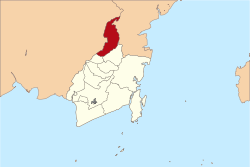
Tabalong Regency is one of the regencies in the Indonesian province of South Kalimantan, on Borneo island. It has an area of 3,766.97 km2, and had a population at the 2010 Census of 218,620;[3] the latest official estimate (as at mid 2019) was 254,322.[4] The administrative capital is the town of Tanjung. Motto: "Saraba Kawa" (Banjarese).
Administrative division[]
The Regency is divided into twelve districts (Indonesian: kecamatan), tabulated below with their areas and population totals from the 2010 Census[5] and the official estimates for mid 2018.[6] The table also includes the number of administrative villages (rural desa and urban kelurahan) in each district, and its postal codes.
| Name | Area in km2 |
Population Census 2010[7] |
Population Estimate mid 2018[8] |
Number of villages |
Post codes |
|---|---|---|---|---|---|
| Banua Lawas | 150.85 | 17,997 | 20,217 | 15 | 71553 (a) |
| Pugaan | 31.88 | 6,479 | 7,328 | 7 | 71554 |
| Kelua | 53.37 | 22,628 | 25,876 | 12 | 71552 |
| Muara Harus | 26.80 | 5,901 | 6,679 | 7 | 71555 |
| Tanta | 149.78 | 17,204 | 19,751 | 14 | 71561 |
| Tanjung | 191.64 | 32,440 | 37,291 | 15 | 71515 (b) |
| Murung Pudak | 172.49 | 44,688 | 51,968 | 10 | 71571 |
| Haruai | 271.97 | 20,416 | 23,073 | 13 | 71570 |
| Bintang Ara | 1,170.18 | 7,935 | 9,165 | 9 | 71572 |
| Upau | 183.01 | 7,046 | 8,040 | 6 | 71575 |
| Muara Uya | 877.41 | 21,689 | 24,884 | 14 | 71573 |
| Jaro | 273.97 | 14,197 | 16,537 | 9 | 71574 |
| Totals | 3,766.97 | 218,620 | 250,809 | 131 |
Notes: (a) except the village of Sungai Durian (postcode of 72167). (a) except the town of Tanjung (postcode of 71513) and the villages of Jangkung (postcode of 71512) and Agung (postcode of 71514).
References[]
- ^ Badan Pusat Statistik, Jakarta, 2020.
- ^ Indeks Pembangunan Manusia Kabupaten Tabalong, Badan Pusat Statistik, 2018
- ^ Biro Pusat Statistik, Jakarta, 2011.
- ^ Badan Pusat Statistik, Jakarta, 2020.
- ^ Biro Pusat Statistik, Jakarta, 2011.
- ^ Badan Pusat Statistik, Jakarta, 2020.
- ^ Biro Pusat Statistik, Jakarta, 2011.
- ^ Badan Pusat Statistik, Jakarta, 2020.
External links[]
| hide Regencies and cities of South Kalimantan | ||
|---|---|---|
Capital: Banjarmasin | ||
| Regencies | ||
| Cities | ||
Coordinates: 1°53′00″S 115°30′00″E / 1.8833°S 115.5000°E

| Authority control |
|
|---|
This South Kalimantan location article is a stub. You can help Wikipedia by . |
- Regencies of South Kalimantan
- Kalimantan geography stubs