List of islands of Mexico

From Wikipedia, the free encyclopedia

This is an incomplete list of islands of Mexico.
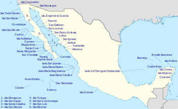
Islands of Mexico


Oceanic Islands (In the Pacific Ocean)[]

Oceanic Islands of the Pacific
Name Location Height Area
Clarion Island 18°21′32″N 114°43′19″W / 18.35889°N 114.72194°W / 18.35889; -114.72194 335 metres (1,099 ft) 19.80 square kilometres (7.64 sq mi)
Guadalupe Island 29°1′51″N 118°16′48″W / 29.03083°N 118.28000°W / 29.03083; -118.28000 1,298 metres (4,259 ft) 244 square kilometres (94 sq mi)
Revillagigedo Archipelago 18°49′N 112°46′W / 18.817°N 112.767°W / 18.817; -112.767 1,130 metres (3,707 ft) 157.81 square kilometres (60.93 sq mi)
Roca Partida 18°59′50″N 112°03′54″W / 18.99722°N 112.06500°W / 18.99722; -112.06500 34 metres (112 ft) 800 m2
Rocas Alijos 24°57′31″N 115°44′59″W / 24.95861°N 115.74972°W / 24.95861; -115.74972 34 metres (112 ft) <1000 m2
San Benedicto Island 19°18′16″N 110°48′52″W / 19.30444°N 110.81444°W / 19.30444; -110.81444 332 metres (1,089 ft) 10 square kilometres (3.9 sq mi)
Socorro Island 18°47′04″N 110°58′30″W / 18.78444°N 110.97500°W / 18.78444; -110.97500 1,150 metres (3,773 ft) 132 square kilometres (51 sq mi)

Islands on the continental shelf[]

Pacific Coast[]

Pacific Coast Islands
Name Location Height Area
Cedros 28°10′58″N 115°13′04″W / 28.18278°N 115.21778°W / 28.18278; -115.21778 348.3 square kilometres (134.5 sq mi)
Isla Coronados 32°24.5′N 117°14.75′W / 32.4083°N 117.24583°W / 32.4083; -117.24583
Isla Magdalena 24°35′N 112°00′W / 24.583°N 112.000°W / 24.583; -112.000
Islas Marías Archipelago 21°31′N 106°29′W / 21.517°N 106.483°W / 21.517; -106.483 245 square kilometres (95 sq mi)
Isla Natividad 27°52′33″N 115°11′05″W / 27.87583°N 115.18472°W / 27.87583; -115.18472
Islas San Benito 28°18′12″N 115°35′24″W / 28.30333°N 115.59000°W / 28.30333; -115.59000 3.899 square kilometres (1.505 sq mi)
Isla San Martin 30°29′20.07″N 116°06′50.61″W / 30.4889083°N 116.1140583°W / 30.4889083; -116.1140583 125m
Santa Margarita 24°35′N 112°00′W / 24.583°N 112.000°W / 24.583; -112.000
Isla Todos Santos 31°47′59″N 116°47′20″W / 31.79972°N 116.78889°W / 31.79972; -116.78889

Gulf of California[]

Islands in Gulf of California
Name Location Height Area
Isla Altamura
Isla Ángel de la Guarda 29°15′36″N 113°22′13″W / 29.26000°N 113.37028°W / 29.26000; -113.37028 1,300 metres (4,265 ft) 931 square kilometres (359 sq mi)
29°00′52.30″N 113°30′19.40″W / 29.0145278°N 113.5053889°W / 29.0145278; -113.5053889
Isla Ballena 24°28′55.97″N 110°24′15.60″W / 24.4822139°N 110.4043333°W / 24.4822139; -110.4043333 30 metres (98 ft)
Isla Bota - The Boot 29°00′38.69″N 113°30′51.92″W / 29.0107472°N 113.5144222°W / 29.0107472; -113.5144222 100 feet (30 m)
Isla Cabeza de Caballo - Head of the Horse 28°58′17.45″N 113°28′43.28″W / 28.9715139°N 113.4786889°W / 28.9715139; -113.4786889 331 feet (101 m)
Isla Calavera - The Skull 29°01′39.60″N 113°29′55.50″W / 29.0276667°N 113.4987500°W / 29.0276667; -113.4987500 100 feet (30 m)
Isla Cerraja - The Lock 28°59′48.33″N 113°31′9.10″W / 28.9967583°N 113.5191944°W / 28.9967583; -113.5191944 49 feet (15 m)
Isla Carmen 25°12′01.0″N 110°41′53.0″W / 25.200278°N 110.698056°W / 25.200278; -110.698056 37,000 acres (58 sq mi)
Isla Cayo
Isla Cerralvo aka Jacques Cousteau Island 24°13′17″N 109°52′14″W / 24.22139°N 109.87056°W / 24.22139; -109.87056Coordinates: 24°13′17″N 109°52′14″W / 24.22139°N 109.87056°W / 24.22139; -109.87056
- Volcano (diminutive) 29°05′54.30″N 113°31′43.10″W / 29.0984167°N 113.5286389°W / 29.0984167; -113.5286389
Isla Coronado (aka. Smith Island) 29°04′26.19″N 113°30′31.34″W / 29.0739417°N 113.5087056°W / 29.0739417; -113.5087056 1,554 feet (474 m)
Isla Coronados
Isla Costanazo 29°59′36.4″N 114°23′23.7″W / 29.993444°N 114.389917°W / 29.993444; -114.389917
Isla Danzante 25°47′11.06″N 111°15′3.85″W / 25.7864056°N 111.2510694°W / 25.7864056; -111.2510694 320 metres (1,050 ft)
Isla Espíritu Santo 24°28′17″N 110°19′57″W / 24.47139°N 110.33250°W / 24.47139; -110.33250
Isla El Coyote
Isla El Muerto 30°5′19.2″N 114°32′35.8″W / 30.088667°N 114.543278°W / 30.088667; -114.543278 490 feet (149 m)
Isla El Requeson
Isla Flecha - The Arrow 29°00′18.78″N 113°31′20.28″W / 29.0052167°N 113.5223000°W / 29.0052167; -113.5223000 203 feet (62 m)
Isla Gallo
Isla Gallina
Isla Huivili - Long Neck 27°03′43″N 109°58′37″W / 27.062°N 109.977°W / 27.062; -109.977
Isla Islitas
30°01′8.6″N 114°28′23.2″W / 30.019056°N 114.473111°W / 30.019056; -114.473111
- The Hunchback 29°00′43.90″N 113°31′27.50″W / 29.0121944°N 113.5243056°W / 29.0121944; -113.5243056
Isla Las Ánimas
Islotes Las Galeras
Isla La Ventana - The Window 28°59′46.09″N 113°30′35.08″W / 28.9961361°N 113.5097444°W / 28.9961361; -113.5097444 112 feet (34 m)
Isla Llave - The Key 28°59′56.10″N 113°31′13.80″W / 28.9989167°N 113.5205000°W / 28.9989167; -113.5205000
30°1′8.8″N 114°27′58.6″W / 30.019111°N 114.466278°W / 30.019111; -114.466278
Isla Mitlan 29°04′1.44″N 113°31′3.90″W / 29.0670667°N 113.5177500°W / 29.0670667; -113.5177500
Isla Montague
Isla Monserrate
Isla Mosca
Isla Partida 24°33′45″N 110°22′42″W / 24.56250°N 110.37833°W / 24.56250; -110.37833
Isla Pata - The Paw 29°00′51.64″N 113°30′50.85″W / 29.0143444°N 113.5141250°W / 29.0143444; -113.5141250
Isla Pardo
- Ducks 29°16′19.1″N 112°27′37.3″W / 29.271972°N 112.460361°W / 29.271972; -112.460361
Isla Piojo - Lice 29°01′4.43″N 113°27′54.58″W / 29.0178972°N 113.4651611°W / 29.0178972; -113.4651611 223 feet (68 m)
Isla Pitahaya, Baja California Sur
30°3′4.8″N 114°29′21.3″W / 30.051333°N 114.489250°W / 30.051333; -114.489250
Isla San Cosme
Isla San Damian
Isla San Diego 25°12′01″N 110°41′53″W / 25.20028°N 110.69806°W / 25.20028; -110.69806
Isla San Esteban 28°41′51″N 112°34′39″W / 28.69750°N 112.57750°W / 28.69750; -112.57750
Isla San Francisco 24°49′50.90″N 110°34′29.25″W / 24.8308056°N 110.5747917°W / 24.8308056; -110.5747917
Isla San Ildefonso
Isla San Lorenzo Sur 28°37′56.10″N 112°48′57.10″W / 28.6322500°N 112.8158611°W / 28.6322500; -112.8158611 460 metres (1,510 ft)
Isla San Luis 29°58′17.41″N 114°24′26.30″W / 29.9715028°N 114.4073056°W / 29.9715028; -114.4073056 150 metres (492 ft)
29°48′51.3″N 114°23′4.1″W / 29.814250°N 114.384472°W / 29.814250; -114.384472
Isla San Pedro Nolasco 27°57′59″N 111°22′42″W / 27.96639°N 111.37833°W / 27.96639; -111.37833
Isla Santa Catalina 25°39′9.53″N 110°46′51.25″W / 25.6526472°N 110.7809028°W / 25.6526472; -110.7809028
Isla Santa Cruz
Islas Santa Inez
Isla Santiago
Isla Tiburón 28°59′20″N 112°22′23″W / 28.98889°N 112.37306°W / 28.98889; -112.37306
Isla Tijeras
Isla Tortuga 27°26′42″N 111°52′51″W / 27.44500°N 111.88083°W / 27.44500; -111.88083
28°57′20.10″N 113°28′43.70″W / 28.9555833°N 113.4788056°W / 28.9555833; -113.4788056

Gulf of Mexico / Caribbean[]

Islands in the Gulf of Mexico or Caribbean Sea
Name Location Height Area
Bermeja (Phantom) 22°38′47.6″N 90°51′23.2″W / 22.646556°N 90.856444°W / 22.646556; -90.856444
21°24′37″N 86°48′37.9″W / 21.41028°N 86.810528°W / 21.41028; -86.810528
Carmen Island 18°38′N 91°50′W / 18.633°N 91.833°W / 18.633; -91.833 3m 28,449 acres (44.452 sq mi)
Isla Contoy 21°30′23″N 86°47′54″W / 21.50639°N 86.79833°W / 21.50639; -86.79833 3.17 square kilometres (1.22 sq mi)
Cozumel 20°25′N 86°55′W / 20.417°N 86.917°W / 20.417; -86.917 14m 647.33 square kilometres (249.94 sq mi)
Cayos Arcas 22°06′52.5″N 91°23′53.2″W / 22.114583°N 91.398111°W / 22.114583; -91.398111 56.3 acres (0.0880 sq mi)
Isla Holbox 21°32′16″N 87°13′12″W / 21.53778°N 87.22000°W / 21.53778; -87.22000 55.95 square kilometres (21.60 sq mi)
Isla Mujeres 21°14′N 86°44′W / 21.233°N 86.733°W / 21.233; -86.733
Arrecife Alacranes 22°22′58″N 89°40′57.8″W / 22.38278°N 89.682722°W / 22.38278; -89.682722

Inner Islands[]

Lake Chapala[]

Lake Pátzcuaro[]

Lake Texcoco[]

External links[]

Media related to Islands of Mexico at Wikimedia Commons

Retrieved from ""