List of mountain peaks of Washington (state)


This article comprises three sortable tables of major mountain peaks[1] of the U.S. State of Washington.
The summit of a mountain or hill may be measured in three principal ways:
- The topographic elevation of a summit measures the height of the summit above a geodetic sea level.[2][3] The first table below ranks the 100 highest major summits of Washington by elevation.
- The topographic prominence of a summit is a measure of how high the summit rises above its surroundings.[4][3] The second table below ranks the 50 most prominent summits of Washington.
- The topographic isolation (or radius of dominance) of a summit measures how far the summit lies from its nearest point of equal elevation.[5] The third table below ranks the 25 most isolated major summits of Washington.
Highest major summits[]
Of the major summits of the State of Washington, Mount Rainier exceeds 4000 meters (13,123 feet) elevation, four peaks exceed 3000 meters (9843 feet) elevation, and 97 peaks exceed 2000 meters (6562 feet) elevation.
| Rank | Mountain peak | Mountain range | Elevation | Prominence | Isolation | Location | First ascent[a] |
|---|---|---|---|---|---|---|---|
| 1 | Mount Rainier (Tahoma)[8][9][10][11][b][c] |
Mount Rainier Area | 14,417 ft 4394 m |
13,246 ft 4037 m |
1,176.72 | 46°51′10″N 121°45′37″W / 46.8529°N 121.7604°W | 1870[d] |
| 2 | Mount Adams (Pahto)[12][13][14][15][16] |
Mount Adams Area | 12,281 ft 3743.4 m |
8,136 ft 2480 m |
45.8 mi 73.6 km |
46°12′09″N 121°29′27″W / 46.2024°N 121.4909°W | 1894 |
| 3 | Mount Baker (Kulshan)[17][18][19][e][f] |
Skagit Range | 10,786 ft 3287 m |
8,845 ft 2696 m |
131.5 mi 212 km |
48°46′36″N 121°48′52″W / 48.7768°N 121.8145°W | 1868 |
| 4 | Glacier Peak (DaKobed)[20][21][22][23][g] |
Glacier Peak Area | 10,545 ft 3214 m |
7,518 ft 2291 m |
56 mi 90.2 km |
48°06′45″N 121°06′50″W / 48.1125°N 121.1138°W | 1897 |
| Mount Saint Helens before 1980 eruption | Mount Saint Helens Area | 9,678 ft 2950 m |
5,937 ft 1810 m |
32 mi 51.5 km |
46°11′49″N 122°11′28″W / 46.1970°N 122.1910°W | 1853 | |
| 5 | Bonanza Peak[24][25][26][h] | Central North Cascades | 9,516 ft 2900 m |
3,731 ft 1137 m |
14.4 mi 23.2 km |
48°14′18″N 120°51′59″W / 48.2382°N 120.8664°W | 1937 |
| 6 | Mount Stuart[27][28][29][30][i][j] | Wenatchee Mountains | 9,420 ft 2871 m |
5,354 ft 1632 m |
44.5 mi 71.6 km |
47°28′30″N 120°54′09″W / 47.4751°N 120.9024°W | 1873 or 1883[6] |
| 7 | Mount Fernow[31][32][33][k][l] | Entiat Mountains | 9,254 ft 2821 m |
2,811 ft 857 m |
5.9 mi 9.49 km |
48°09′45″N 120°48′27″W / 48.1625°N 120.8075°W | 1933 |
| 8 | Goode Mountain[34][35][36][m] | Central North Cascades | 9,224 ft 2812 m |
3,828 ft 1167 m |
17.02 mi 27.4 km |
48°28′59″N 120°54′41″W / 48.4831°N 120.9115°W | 1936 |
| 9 | Mount Shuksan[37][38][39][40][n] | Skagit Range | 9,135 ft 2784 m |
4,431 ft 1351 m |
10.36 mi 16.68 km |
48°49′53″N 121°36′12″W / 48.8315°N 121.6032°W | 1897 or 1906[6] |
| 10 | Buckner Mountain[41][42][43][o] | Central North Cascades | 9,119 ft 2779 m |
3,054 ft 931 m |
4.13 mi 6.65 km |
48°29′39″N 121°00′00″W / 48.4943°N 120.9999°W | 1901 |
| 11 | Jack Mountain[44][45][46][47][p] | Hozameen Range | 9,075 ft 2766 m |
4,211 ft 1284 m |
16.32 mi 26.3 km |
48°46′22″N 120°57′22″W / 48.7728°N 120.9562°W | 1904 |
| 12 | Mount Spickard[48][49][50][51] | Skagit Range | 8,980 ft 2737.2 m |
4,799 ft 1463 m |
18.78 mi 30.2 km |
48°58′11″N 121°14′26″W / 48.9697°N 121.2405°W | 1904 |
| 13 | Black Peak[52][53][54][q] | Central North Cascades | 8,975 ft 2735 m |
3,470 ft 1058 m |
5.19 mi 8.36 km |
48°31′25″N 120°48′58″W / 48.5236°N 120.8162°W | 1926 |
| 14 | Mount Redoubt[55][56][57][r] | Skagit Range | 8,974 ft 2735 m |
1,669 ft 509 m |
2.86 mi 4.61 km |
48°57′28″N 121°18′03″W / 48.9578°N 121.3007°W | 1930 |
| 15 | North Gardner Mountain[58][59][60][s][t] | Central North Cascades | 8,961 ft 2731 m |
4,016 ft 1224 m |
14.42 mi 23.2 km |
48°30′55″N 120°30′06″W / 48.5152°N 120.5017°W | 1925 |
| 16 | Dome Peak[61][62][63][64][u][v] | Central North Cascades | 8,945 ft 2726 m |
3,080 ft 939 m |
8.46 mi 13.61 km |
48°18′12″N 121°01′46″W / 48.3034°N 121.0295°W | 1936 |
| 17 | Silver Star Mountain[65][66][67][w] | Methow Mountains | 8,881 ft 2707 m |
2,456 ft 749 m |
4.45 mi 7.16 km |
48°32′52″N 120°35′06″W / 48.5479°N 120.5851°W | 1926 |
| 18 | Eldorado Peak[68][69][70][71][x] | Central North Cascades | 8,873 ft 2704 m |
2,205 ft 672 m |
5.36 mi 8.63 km |
48°32′15″N 121°08′04″W / 48.5374°N 121.1345°W | 1933 |
| 19 | Dragontail Peak[72][73][74][y] | Wenatchee Mountains | 8,865 ft 2702 m |
1,800 ft 549 m |
3.11 mi 5 km |
47°28′44″N 120°50′00″W / 47.4789°N 120.8332°W | 1937 |
| 20 | Oval Peak[75][76][77][78][z] | Methow Mountains | 8,807 ft 2684.5 m |
2,731 ft 832 m |
15.47 mi 24.9 km |
48°17′14″N 120°25′30″W / 48.2872°N 120.4251°W | 1989 |
| 21 | Mesahchie Peak[79] | Central North Cascades | 8,799 ft 2682 m |
2,255 ft 687 m |
3.84 mi 6.18 km |
48°34′43″N 120°52′49″W / 48.5786°N 120.8803°W | 1966 |
| 22 | Fortress Mountain[80] | Glacier Peak Area | 8,763 ft 2671 m |
1,720 ft 524 m |
5.49 mi 8.84 km |
48°09′35″N 120°56′00″W / 48.1598°N 120.9332°W | 1921 or 1944 |
| 23 | Mount Lago[81][82][83][aa][ab] | Okanogan Range | 8,750 ft 2667 m |
3,268 ft 996 m |
19.52 mi 31.4 km |
48°49′45″N 120°32′15″W / 48.8293°N 120.5374°W | 1925 |
| 24 | Robinson Mountain[84] | Okanogan Range | 8,730 ft 2661 m |
1,706 ft 520 m |
7.28 mi 11.72 km |
48°43′36″N 120°34′30″W / 48.7268°N 120.5751°W | 1904 |
| 25 | Remmel Mountain[85][86][87][88][ac] | Okanogan Range | 8,691 ft 2649.16 m |
4,385 ft 1337 m |
16.83 mi 27.1 km |
48°55′24″N 120°11′48″W / 48.9234°N 120.1968°W | 1904 |
| 26 | Martin Peak[89] | Methow Mountains | 8,510 ft 2594 m |
2,131 ft 650 m |
1.95 mi 3.14 km |
48°14′30″N 120°48′57″W / 48.2417°N 120.8158°W | 1936 |
| 27 | Big Craggy Peak[90] | Okanogan Range | 8,474 ft 2583 m |
3,090 ft 942 m |
10.02 mi 16.13 km |
48°45′47″N 120°19′41″W / 48.7630°N 120.3280°W | 1960 ? |
| 28 | Pinnacle Mountain[91] | Chelan Mountains | 8,468 ft 2581 m |
1,760 ft 536 m |
1.87 mi 3.01 km |
48°07′56″N 120°40′14″W / 48.1321°N 120.6705°W | 1948 |
| Lost Peak[92] | Okanogan Range | 8,468 ft 2581 m |
1,644 ft 501 m |
3.61 mi 5.81 km |
48°48′46″N 120°27′30″W / 48.8129°N 120.4583°W | 1925 | |
| 30 | Tower Mountain[93] | Okanogan Range | 8,445 ft 2574 m |
2,904 ft 885 m |
5.87 mi 9.45 km |
48°35′19″N 120°42′15″W / 48.5885°N 120.7042°W | 1913 |
| 31 | Azurite Peak[94] | Okanogan Range | 8,402 ft 2561 m |
1,920 ft 585 m |
5.24 mi 8.43 km |
48°39′26″N 120°45′08″W / 48.6573°N 120.7521°W | 1933 |
| 32 | Reynolds Peak[95] | Methow Mountains | 8,383 ft 2555 m |
2,052 ft 625 m |
8.55 mi 13.76 km |
48°22′20″N 120°33′47″W / 48.3723°N 120.5630°W | 1898 |
| 33 | Devore Peak[96] | Central North Cascades | 8,363 ft 2549 m |
1,742 ft 531 m |
3.36 mi 5.41 km |
48°16′36″N 120°45′55″W / 48.2768°N 120.7653°W | 1940 |
| 34 | Snowfield Peak[97] | Central North Cascades | 8,350 ft 2545 m |
2,927 ft 892 m |
4.24 mi 6.83 km |
48°38′07″N 121°08′20″W / 48.6353°N 121.1388°W | 1931 |
| 35 | Mount Saint Helens[98][99][100][ad] | Mount Saint Helens Area | 8,337 ft 2541 m |
4,593 ft 1400 m |
32 mi 51.5 km |
46°11′29″N 122°11′44″W / 46.1914°N 122.1956°W | 1853 |
| 36 | Windy Peak[101][102][103][ae] | Okanogan Range | 8,333 ft 2540 m |
1,787 ft 545 m |
9.23 mi 14.86 km |
48°55′42″N 119°58′14″W / 48.9283°N 119.9706°W | 1904 |
| 37 | Mount Formidable[104] | Central North Cascades | 8,327 ft 2538 m |
1,905 ft 581 m |
5.25 mi 8.45 km |
48°24′59″N 121°04′02″W / 48.4163°N 121.0671°W | 1938 |
| 38 | Flora Mountain[105] | Central North Cascades | 8,323 ft 2537 m |
1,820 ft 555 m |
3.95 mi 6.36 km |
48°14′35″N 120°41′45″W / 48.2431°N 120.6957°W | 1940 |
| 39 | Luna Peak[106] | Skagit Range | 8,314 ft 2534 m |
3,105 ft 946 m |
8.07 mi 12.98 km |
48°49′51″N 121°16′20″W / 48.8308°N 121.2721°W | 1938 |
| 40 | Castle Peak[107][108][109][af] | Hozameen Range | 8,311 ft 2533 m |
3,246 ft 989 m |
14.82 mi 23.9 km |
48°58′56″N 120°51′44″W / 48.9821°N 120.8622°W | 1904 |
| 41 | Sentinel Peak[110] | Central North Cascades | 8,264 ft 2519 m |
1,681 ft 512 m |
3.03 mi 4.87 km |
48°21′22″N 121°02′27″W / 48.3562°N 121.0409°W | 1935 |
| 42 | Tiffany Mountain[111][112][113][114][ag] | Okanogan Range | 8,250 ft 2514.71 m |
2,782 ft 848 m |
17.97 mi 28.9 km |
48°40′11″N 119°55′57″W / 48.6696°N 119.9325°W | < 1900 |
| 43 | Gilbert Peak[115][116][117][ah] | South Washington Cascades | 8,188 ft 2496 m |
3,684 ft 1123 m |
20.1 mi 32.4 km |
46°29′19″N 121°24′30″W / 46.4886°N 121.4084°W | 1899 |
| 44 | Mount Terror[118] | Skagit Range | 8,153 ft 2485 m |
1,934 ft 589 m |
2.5 mi 4.03 km |
48°46′29″N 121°17′58″W / 48.7748°N 121.2994°W | 1932 |
| 45 | The Needles[119] | Okanogan Range | 8,140 ft 2481 m |
1,759 ft 536 m |
2.26 mi 3.64 km |
48°35′59″N 120°39′27″W / 48.5998°N 120.6574°W | 1944 |
| 46 | Crater Mountain[120] | Hozameen Range | 8,130 ft 2478 m |
1,948 ft 594 m |
2.67 mi 4.29 km |
48°44′21″N 120°55′13″W / 48.7393°N 120.9202°W | < 1929 |
| 47 | McGregor Mountain[121] | Methow Mountains | 8,127 ft 2477 m |
2,142 ft 653 m |
6.9 mi 11.11 km |
48°24′30″N 120°47′54″W / 48.4082°N 120.7982°W | |
| 48 | Big Chiwaukum[122][123][ai][aj] | Wenatchee Mountains | 8,086 ft 2464 m |
3,701 ft 1128 m |
10.43 mi 16.78 km |
47°42′09″N 120°56′05″W / 47.7024°N 120.9347°W | |
| 49 | Hozomeen North Peak[124][125][126][127] | Hozameen Range | 8,071 ft 2460 m |
3,947 ft 1203 m |
6.82 mi 10.97 km |
48°58′56″N 121°00′43″W / 48.9822°N 121.0120°W | 1904 |
| 50 | Cutthroat Peak[128] | Okanogan Range | 8,054 ft 2455 m |
1,750 ft 533 m |
3.84 mi 6.18 km |
48°31′35″N 120°42′13″W / 48.5264°N 120.7035°W | 1937 |
| 51 | American Border Peak (Tum mea hal)[129] |
Skagit Range | 7,999 ft 2438 m |
2,934 ft 894 m |
11.23 mi 18.07 km |
48°59′43″N 121°39′54″W / 48.9954°N 121.6651°W | 1930 |
| 52 | Mount Olympus[130][131][132][133][ak] | Olympic Mountains | 7,980 ft 2432.3 m |
7,838 ft 2389 m |
108 mi 173.7 km |
47°48′05″N 123°42′39″W / 47.8013°N 123.7108°W | |
| 53 | Three Fools Peak[134] | Hozameen Range | 7,923 ft 2415 m |
2,489 ft 759 m |
7.05 mi 11.35 km |
48°54′02″N 120°45′48″W / 48.9006°N 120.7633°W | 1925 |
| Gabriel Peak[135] | Central North Cascades | 7,923 ft 2415 m |
1,960 ft 597 m |
2.63 mi 4.23 km |
48°37′40″N 120°56′07″W / 48.6278°N 120.9353°W | ||
| 55 | Mount Daniel NW summit[136][137][138][139] | Alpine Lakes Area | 7,904 ft 2409 m |
3,520 ft 1073 m |
13.45 mi 21.6 km |
47°33′45″N 121°10′19″W / 47.5626°N 121.1720°W | < 1925[al] |
| 56 | Chopaka Mountain[140] | Okanogan Range | 7,884 ft 2403 m |
1,827 ft 557 m |
6.39 mi 10.29 km |
48°57′27″N 119°47′05″W / 48.9574°N 119.7848°W | 1901 |
| 57 | Plummer Mountain[141] | Central North Cascades | 7,874 ft 2400 m |
1,970 ft 600 m |
2.48 mi 3.99 km |
48°12′26″N 120°58′20″W / 48.2071°N 120.9721°W | |
| 58 | Sloan Peak[142][143][144][145] | Mountain Loop Area | 7,835 ft 2388 m |
3,895 ft 1187 m |
11.12 mi 17.89 km |
48°02′29″N 121°20′25″W / 48.0415°N 121.3402°W | 1921 |
| 59 | Mount Deception[146][147][148][am] | Central Olympic Mountains | 7,792 ft 2375 m |
4,128 ft 1258 m |
21.7 mi 35 km |
47°48′48″N 123°14′00″W / 47.8134°N 123.2334°W | |
| 60 | Mount Aix[149][150][151][152] | South Cascade Crest | 7,770 ft 2368.3 m |
3,296 ft 1005 m |
20.6 mi 33.2 km |
46°47′42″N 121°15′21″W / 46.7950°N 121.2559°W | |
| 61 | Mount Constance[153] | Eastern Olympic Mountains | 7,759 ft 2365 m |
1,976 ft 602 m |
5.67 mi 9.13 km |
47°46′22″N 123°07′38″W / 47.7728°N 123.1273°W | 1922 |
| 62 | Elija Ridge[154] | Central North Cascades | 7,743 ft 2360 m |
2,039 ft 621 m |
1.79 mi 2.88 km |
48°39′01″N 120°57′36″W / 48.6504°N 120.9601°W | |
| 63 | Chimney Rock[155] | Alpine Lakes Area | 7,730 ft 2356 m |
2,747 ft 837 m |
6.42 mi 10.33 km |
47°30′26″N 121°17′24″W / 47.5071°N 121.2901°W | 1930 |
| 64 | Mount Blum[156][157][158][159] | Skagit Range | 7,685 ft 2342.3 m |
3,300 ft 1006 m |
6.05 mi 9.73 km |
48°45′15″N 121°28′57″W / 48.7541°N 121.4825°W | 1920s |
| 65 | Mount Prophet[160][161][162][an] | Skagit Range | 7,674 ft 2339 m |
4,040 ft 1231 m |
5.13 mi 8.26 km |
48°50′55″N 121°09′46″W / 48.8486°N 121.1628°W | 1975 |
| 66 | [163] | Hozameen Range | 7,516 ft 2291 m |
2,214 ft 675 m |
3.11 mi 5 km |
48°50′04″N 120°50′23″W / 48.8344°N 120.8397°W | |
| 67 | The Cradle[164] | Wenatchee Mountains | 7,470 ft 2277 m |
2,127 ft 648 m |
5.71 mi 9.19 km |
47°33′39″N 121°01′59″W / 47.5608°N 121.0330°W | 1944 |
| 68 | Mount Misch[165] | Central North Cascades | 7,438 ft 2267 m |
2,455 ft 748 m |
5.3 mi 8.53 km |
48°20′37″N 121°12′00″W / 48.3435°N 121.2000°W | 1955 |
| Tomyhoi Peak (Put-lush-go-hap)[166] |
Skagit Range | 7,438 ft 2267 m |
2,055 ft 626 m |
2.4 mi 3.87 km |
48°58′30″N 121°42′35″W / 48.9749°N 121.7098°W | 1927 ? | |
| 70 | Mount David[167] | Glacier Peak Area | 7,425 ft 2263 m |
2,440 ft 744 m |
5.57 mi 8.97 km |
47°57′47″N 120°59′22″W / 47.9631°N 120.9895°W | |
| 71 | Ruby Mountain[168][169][170] | Central North Cascades | 7,408 ft 2258 m |
3,908 ft 1191 m |
4.27 mi 6.87 km |
48°41′40″N 121°02′34″W / 48.6944°N 121.0429°W | 1916 |
| 72 | Indian Head Peak[171] | Glacier Peak Area | 7,405 ft 2257 m |
2,040 ft 622 m |
3.29 mi 5.29 km |
48°00′28″N 121°05′52″W / 48.0079°N 121.0978°W | 1870 |
| 73 | West Peak[172] | Central Olympic Mountains | 7,369 ft 2246 m |
1,985 ft 605 m |
7.73 mi 12.44 km |
47°43′24″N 123°20′57″W / 47.7232°N 123.3492°W | 1930 |
| 74 | Gypsy Peak[173] | Priest Lake Selkirks | 7,323 ft 2232 m |
1,760 ft 536 m |
6.43 mi 10.35 km |
48°56′45″N 117°09′09″W / 48.9458°N 117.1524°W | |
| 75 | Abercrombie Mountain[174][175][176][ao] | Southwest Selkirks | 7,312 ft 2229 m |
5,178 ft 1578 m |
14.04 mi 22.6 km |
48°55′42″N 117°27′36″W / 48.9284°N 117.4600°W | |
| 76 | Kyes Peak[177] | Mountain Loop Area | 7,283 ft 2220 m |
1,760 ft 536 m |
5.21 mi 8.39 km |
47°57′53″N 121°20′01″W / 47.9647°N 121.3337°W | 1897 |
| 77 | [178][179][180][181] | Okanogan Highlands | 7,262 ft 2213.6 m |
3,557 ft 1084 m |
26.7 mi 43 km |
48°47′07″N 119°07′20″W / 48.7852°N 119.1223°W | |
| 78 | Mount Triumph[182] | Skagit Range | 7,244 ft 2208 m |
1,760 ft 536 m |
2.32 mi 3.73 km |
48°42′24″N 121°21′22″W / 48.7067°N 121.3562°W | 1938 |
| 79 | Mount Despair[183] | Skagit Range | 7,241 ft 2207 m |
1,872 ft 571 m |
3.76 mi 6.05 km |
48°44′14″N 121°22′36″W / 48.7373°N 121.3768°W | 1937 |
| 80 | Mount Pugh (Da Klagwats)[184] |
Glacier Peak Area | 7,205 ft 2196 m |
2,821 ft 860 m |
6.95 mi 11.18 km |
48°08′35″N 121°22′28″W / 48.1431°N 121.3744°W | 1916 |
| 81 | [185][186][187][188][ap] | Monashee Mountains | 7,150 ft 2179.3 m |
4,760 ft 1451 m |
30.2 mi 48.7 km |
48°42′09″N 118°27′56″W / 48.7025°N 118.4656°W | |
| 82 | Mount Howard[189] | Glacier Peak Area | 7,067 ft 2154 m |
2,923 ft 891 m |
5.24 mi 8.44 km |
47°48′52″N 120°57′17″W / 47.8145°N 120.9546°W | < 1887 |
| 83 | Bacon Peak[190] | Skagit Range | 7,064 ft 2153 m |
2,505 ft 764 m |
4.46 mi 7.17 km |
48°39′46″N 121°31′14″W / 48.6627°N 121.5206°W | 1905 |
| 84 | Davis Peak[191] | Skagit Range | 7,054 ft 2150 m |
1,791 ft 546 m |
2.96 mi 4.76 km |
48°43′46″N 121°12′11″W / 48.7295°N 121.2030°W | 1904 |
| 85 | Crystal Mountain[192] | South Cascade Crest | 7,001 ft 2134 m |
2,304 ft 702 m |
5.06 mi 8.14 km |
46°54′57″N 121°30′14″W / 46.9159°N 121.5040°W | |
| 86 | White Chuck Mountain (Hi Khaed)[193][194][195][196] |
Mountain Loop Area | 6,989 ft 2130 m |
3,809 ft 1161 m |
4.93 mi 7.93 km |
48°12′31″N 121°25′01″W / 48.2085°N 121.4169°W | 1897 |
| 87 | Unicorn Peak[197] | Tatoosh Range | 6,975 ft 2126 m |
2,104 ft 641 m |
4.34 mi 6.98 km |
46°44′42″N 121°42′03″W / 46.7451°N 121.7009°W | |
| 88 | South Twin[198][199][200][201] | Skagit Range | 6,936 ft 2114.15 m |
3,560 ft 1085 m |
6.9 mi 11.11 km |
48°42′18″N 121°59′15″W / 48.7049°N 121.9874°W | 1891 |
| 89 | [202] | Wenatchee Mountains | 6,880 ft 2097 m |
2,809 ft 856 m |
17.98 mi 28.9 km |
47°17′05″N 120°26′28″W / 47.2848°N 120.4412°W | |
| 90 | [203][204][205][206] | Southwest Selkirks | 6,861 ft 2091.3 m |
3,645 ft 1111 m |
33.6 mi 54.1 km |
48°26′13″N 117°30′09″W / 48.4369°N 117.5025°W | |
| 91 | Three Fingers (Queest Alb)[207][208][209][210][aq] |
Mountain Loop Area | 6,859 ft 2090.6 m |
4,510 ft 1375 m |
12.79 mi 20.6 km |
48°10′12″N 121°41′16″W / 48.1699°N 121.6878°W | 1931 |
| 92 | The Brothers S summit[211] | Eastern Olympic Mountains | 6,844 ft 2086 m |
2,702 ft 824 m |
7.12 mi 11.46 km |
47°39′14″N 123°08′26″W / 47.6538°N 123.1406°W | 1912 |
| Whitehorse Mountain (So-bahli-ahli)[212] |
Mountain Loop Area | 6,844 ft 2086 m |
2,200 ft 671 m |
2.86 mi 4.61 km |
48°12′40″N 121°40′40″W / 48.2110°N 121.6777°W | 1909 | |
| 94 | [213] | Southwest Selkirks | 6,788 ft 2069 m |
2,364 ft 721 m |
12.4 mi 19.95 km |
48°42′37″N 117°17′11″W / 48.7102°N 117.2863°W | |
| 95 | [214][215][216][217] | Okanogan Highlands | 6,778 ft 2066 m |
4,154 ft 1266 m |
28.6 mi 46.1 km |
48°22′19″N 119°03′41″W / 48.3719°N 119.0613°W | |
| 96 | Del Campo Peak[218] | Mountain Loop Area | 6,614 ft 2016 m |
2,230 ft 680 m |
3.84 mi 6.18 km |
47°59′27″N 121°28′14″W / 47.9907°N 121.4706°W | <= 1912 |
| Mount Stone[219] | Eastern Olympic Mountains | 6,614 ft 2016 m |
2,152 ft 656 m |
6.67 mi 10.74 km |
47°36′23″N 123°16′00″W / 47.6063°N 123.2666°W | 1932 | |
| 98 | [220][221][222][223][ar][as] | Blue Mountains | 6,391 ft 1947.9 m |
2,417 ft 737 m |
46.5 mi 74.8 km |
46°06′37″N 117°40′47″W / 46.1104°N 117.6797°W | |
| 99 | Dirtyface Peak[224][225][226][at] | Glacier Peak Area | 6,264 ft 1909 m |
3,360 ft 1024 m |
4.78 mi 7.7 km |
47°52′17″N 120°49′31″W / 47.8713°N 120.8253°W | 1898 |
| 100 | Mount Washington[227] | Eastern Olympic Mountains | 6,260 ft 1908 m |
2,635 ft 803 m |
4.69 mi 7.54 km |
47°31′53″N 123°14′46″W / 47.5313°N 123.2460°W |

Most prominent summits[]
Of the most prominent summits of the State of Washington, Mount Rainier exceeds 4000 meters (13,123 feet) of topographic prominence, five peaks exceed 2000 meters (6562 feet), seven peaks are ultra-prominent summits with more than 1500 meters (4921 feet) of topographic prominence, and 40 peaks exceed 1000 meters (3281 feet) of topographic prominence.
Most isolated major summits[]
Of the major summits of the State of Washington, Mount Rainier exceeds 1000 kilometers (621.4 miles) of topographic isolation, three peaks exceed 100 kilometers (62.14 miles), and 16 exceed 40 kilometers (24.85 miles) of topographic isolation.
| Rank | Mountain peak | Mountain range | Elevation | Prominence | Isolation | Location | First ascent |
|---|---|---|---|---|---|---|---|
| 1 | Mount Rainier (Tahoma)[8][9][10][11][b][c] |
Mount Rainier Area | 14,417 ft 4394 m |
13,246 ft 4037 m |
731 mi 1,177 km |
46°51′10″N 121°45′37″W / 46.8529°N 121.7604°W | 1870[bc] |
| 2 | Mount Baker {Kulshan)[17][18][19][e][f] |
Skagit Range | 10,786 ft 3287 m |
8,845 ft 2696 m |
131.5 mi 212 km |
48°46′36″N 121°48′52″W / 48.7768°N 121.8145°W | 1868 |
| 3 | Mount Olympus[130][131][132][133][ak] | Olympic Mountains | 7,980 ft 2432.3 m |
7,838 ft 2389 m |
108 mi 173.7 km |
47°48′05″N 123°42′39″W / 47.8013°N 123.7108°W | |
| 4 | Glacier Peak (DaKobed)[20][21][22][23][g] |
Glacier Peak Area | 10,545 ft 3214 m |
7,518 ft 2291 m |
56 mi 90.2 km |
48°06′45″N 121°06′50″W / 48.1125°N 121.1138°W | 1897 |
| 5 | [220][221][222][223][ar][as] | Blue Mountains | 6,391 ft 1947.9 m |
2,417 ft 737 m |
46.5 mi 74.8 km |
46°06′37″N 117°40′47″W / 46.1104°N 117.6797°W | |
| 6 | Mount Adams (Pahto)[12][13][14][15][16] |
Mount Adams Area | 12,281 ft 3743.4 m |
8,136 ft 2480 m |
45.8 mi 73.6 km |
46°12′09″N 121°29′27″W / 46.2024°N 121.4909°W | 1894 |
| 7 | Mount Stuart[27][28][29][30][i][j] | Wenatchee Mountains | 9,420 ft 2871 m |
5,354 ft 1632 m |
44.5 mi 71.6 km |
47°28′30″N 120°54′09″W / 47.4751°N 120.9024°W | 1873 or 1883[6] |
| 8 | Boistfort Peak[254][255][256][bd] | Willapa Hills | 3,113 ft 948.9 m |
2,710 ft 826 m |
34.5 mi 55.5 km |
46°29′17″N 123°12′55″W / 46.4881°N 123.2153°W | |
| 9 | [203][204][205][206] | Southwest Selkirks | 6,861 ft 2091.3 m |
3,645 ft 1111 m |
33.6 mi 54.1 km |
48°26′13″N 117°30′09″W / 48.4369°N 117.5025°W | |
| 10 | Mount Spokane[238][239][240][241] | Southwest Selkirks | 5,887 ft 1794.4 m |
3,508 ft 1069 m |
33.2 mi 53.5 km |
47°55′25″N 117°06′44″W / 47.9236°N 117.1122°W | |
| 11 | Mount Saint Helens[98][99][100][ad] | Mount Saint Helens Area | 8,337 ft 2541 m |
4,593 ft 1400 m |
32 mi 51.5 km |
46°11′29″N 122°11′44″W / 46.1914°N 122.1956°W | 1853 |
| 12 | Indian Rock[257] | North Columbia Plateau | 5,850 ft 1783 m |
2,575 ft 785 m |
30.4 mi 49 km |
45°59′38″N 120°49′24″W / 45.9939°N 120.8232°W | |
| 13 | [185][186][187][188][ap] | Monashee Mountains | 7,150 ft 2179.3 m |
4,760 ft 1451 m |
30.2 mi 48.7 km |
48°42′09″N 118°27′56″W / 48.7025°N 118.4656°W | |
| 14 | [214][215][216][217] | Okanogan Highlands | 6,778 ft 2066 m |
4,154 ft 1266 m |
28.6 mi 46.1 km |
48°22′19″N 119°03′41″W / 48.3719°N 119.0613°W | |
| 15 | [178][179][180][181] | Okanogan Highlands | 7,262 ft 2213.6 m |
3,557 ft 1084 m |
26.7 mi 43 km |
48°47′07″N 119°07′20″W / 48.7852°N 119.1223°W | |
| 16 | [231][232][233][234][aw] | Southwest Selkirks | 5,826 ft 1775.8 m |
3,875 ft 1181 m |
25.4 mi 40.8 km |
48°12′44″N 117°58′36″W / 48.2122°N 117.9766°W | |
| 17 | Mount Deception[146][147][148][am] | Central Olympic Mountains | 7,792 ft 2375 m |
4,128 ft 1258 m |
21.7 mi 35 km |
47°48′48″N 123°14′00″W / 47.8134°N 123.2334°W | |
| 18 | Mount Constitution[258][259][260][be] | Orcas Island | 2,399 ft 731.15 m |
2,399 ft 731 m |
21.4 mi 34.4 km |
48°40′39″N 122°49′52″W / 48.6776°N 122.8312°W | |
| 19 | Mount Aix[149][150][151][152] | South Cascade Crest | 7,770 ft 2368.3 m |
3,296 ft 1005 m |
20.6 mi 33.2 km |
46°47′42″N 121°15′21″W / 46.7950°N 121.2559°W | |
| 20 | Gilbert Peak[115][116][117][ah] | South Washington Cascades | 8,188 ft 2496 m |
3,684 ft 1123 m |
20.1 mi 32.4 km |
46°29′19″N 121°24′30″W / 46.4886°N 121.4084°W | 1899 |
| 21 | Mount Lago[81][82][83][aa][ab] | Okanogan Range | 8,750 ft 2667 m |
3,268 ft 996 m |
19.52 mi 31.4 km |
48°49′45″N 120°32′15″W / 48.8293°N 120.5374°W | 1925 |
| 22 | Mount Spickard[48][49][50][51] | Skagit Range | 8,980 ft 2737.2 m |
4,799 ft 1463 m |
18.78 mi 30.2 km |
48°58′11″N 121°14′26″W / 48.9697°N 121.2405°W | 1904 |
| 23 | [202] | Wenatchee Mountains | 6,880 ft 2097 m |
2,809 ft 856 m |
17.98 mi 28.9 km |
47°17′05″N 120°26′28″W / 47.2848°N 120.4412°W | |
| 24 | Tiffany Mountain[111][112][113][114][ag] | Okanogan Range | 8,250 ft 2514.71 m |
2,782 ft 848 m |
17.97 mi 28.9 km |
48°40′11″N 119°55′57″W / 48.6696°N 119.9325°W | < 1900 |
| 25 | Goode Mountain[34][35][36][m] | Central North Cascades | 9,224 ft 2812 m |
3,828 ft 1167 m |
17.02 mi 27.4 km |
48°28′59″N 120°54′41″W / 48.4831°N 120.9115°W | 1936 |
Gallery[]

Mount Adams is the second highest summit of the U.S. State of Washington.
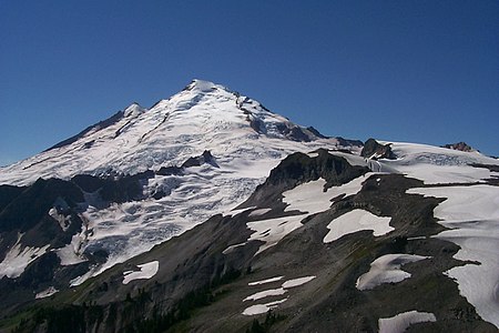
Mount Baker is the highest summit of the northern Cascade Range.

Glacier Peak is the fourth highest summit of the U.S. State of Washington.
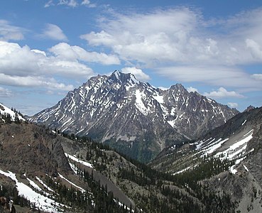
Mount Stuart is the highest summit of the Wenatchee Mountains.

Mount Olympus is the highest summit of the Olympic Mountains.


See also[]
- List of mountain peaks of North America
- List of mountain peaks of Greenland
- List of mountain peaks of Canada
- List of mountain peaks of the Rocky Mountains
- List of mountain peaks of the United States
- List of mountain peaks of Alaska
- List of mountain peaks of Arizona
- List of mountain peaks of California
- List of mountain peaks of Colorado
- List of mountain peaks of Hawaiʻi
- List of mountain peaks of Idaho
- List of mountain peaks of Montana
- List of mountain peaks of Nevada
- List of mountain peaks of New Mexico
- List of mountain peaks of Oregon
- List of mountain peaks of Utah
- List of mountain peaks of Washington (state)
- List of mountains of Washington (state)
- List of mountain ranges in Washington (state)
- List of mountain peaks of Wyoming
- List of mountain peaks of México
- List of mountain peaks of Central America
- List of mountain peaks of the Caribbean
- Washington (state)
- Geography of Washington (state)
- Category:Mountains of Washington (state)
- Geography of Washington (state)
- Physical geography
Notes[]
- ^ First recorded ascents. Sources: for Castle Peak (8311 ft) and higher the years are copied from John Roper's carefully curated list.[6] Years for lower mountains in the Cascades mainly come from the Cascade Alpine Guides and in the Olympic mountains from Steph Abegg's list.[7]
- ^ Jump up to: a b c The summit of Mount Rainier
(Tahoma) is the highest point of the Cascade Range and the U.S. State of Washington. Mount Rainier is the most prominent summit in the contiguous United States and the fourth most prominent in North America. - ^ Jump up to: a b c The elevation of Mount Rainier
(Tahoma) includes an adjustment of +1.914 m (6.28 ft) from NGVD 29 to NAVD 88. - ^ Or perhaps as early as 1858 by two unidentified miners[6]
- ^ Jump up to: a b c The summit of Mount Baker
(Kulshan) is the highest point of the northern Cascade Range. Cite error: The named reference "X_Mount Baker" was defined multiple times with different content (see the help page). - ^ Jump up to: a b c The elevation of Mount Baker
(Kulshan) includes an adjustment of +1.43 m (4.69 ft) from NGVD 29 to NAVD 88. Cite error: The named reference "H_Mount Baker" was defined multiple times with different content (see the help page). - ^ Jump up to: a b c The elevation of Glacier Peak
(DaKobed) includes an adjustment of +1.492 m (4.9 ft) from NGVD 29 to NAVD 88. - ^ Jump up to: a b The elevation of Bonanza Peak includes an adjustment of +1.436 m (4.71 ft) from NGVD 29 to NAVD 88.
- ^ Jump up to: a b c The summit of Mount Stuart is the highest point of the Wenatchee Mountains.
- ^ Jump up to: a b c The elevation of Mount Stuart includes an adjustment of +1.388 m (4.55 ft) from NGVD 29 to NAVD 88.
- ^ The summit of Mount Fernow is the highest point of the Entiat Mountains.
- ^ The elevation of Mount Fernow includes an adjustment of +1.456 m (4.78 ft) from NGVD 29 to NAVD 88.
- ^ Jump up to: a b c The elevation of Goode Mountain includes an adjustment of +1.364 m (4.48 ft) from NGVD 29 to NAVD 88.
- ^ Jump up to: a b The elevation of Mount Shuksan includes an adjustment of +1.339 m (4.39 ft) from NGVD 29 to NAVD 88.
- ^ Jump up to: a b The elevation of Buckner Mountain includes an adjustment of +1.414 m (4.64 ft) from NGVD 29 to NAVD 88.
- ^ Jump up to: a b The summit of Jack Mountain is the highest point of the Hozameen Range.
- ^ Jump up to: a b The elevation of Black Peak includes an adjustment of +1.392 m (4.57 ft) from NGVD 29 to NAVD 88.
- ^ The elevation of Mount Redoubt includes an adjustment of +1.412 m (4.63 ft) from NGVD 29 to NAVD 88.
- ^ Jump up to: a b The summit of North Gardner Mountain is the highest point of the .
- ^ Jump up to: a b The elevation of North Gardner Mountain includes an adjustment of +1.425 m (4.68 ft) from NGVD 29 to NAVD 88.
- ^ Jump up to: a b The summit of Dome Peak is the highest point of .
- ^ Jump up to: a b The elevation of Dome Peak includes an adjustment of +1.422 m (4.67 ft) from NGVD 29 to NAVD 88.
- ^ The elevation of Silver Star Mountain includes an adjustment of +1.432 m (4.7 ft) from NGVD 29 to NAVD 88.
- ^ The elevation of Eldorado Peak includes an adjustment of +1.382 m (4.53 ft) from NGVD 29 to NAVD 88.
- ^ The elevation of Dragontail Peak includes an adjustment of +1.379 m (4.52 ft) from NGVD 29 to NAVD 88.
- ^ The summit of Oval Peak is the highest point of .
- ^ Jump up to: a b c The summit of Mount Lago is the highest point of the Okanogan Range.
- ^ Jump up to: a b c The elevation of Mount Lago includes an adjustment of +1.472 m (4.83 ft) from NGVD 29 to NAVD 88.
- ^ Jump up to: a b The summit of Remmel Mountain is the highest point of the Cathedral Range.
- ^ Jump up to: a b c The elevation of Mount Saint Helens includes an adjustment of +1.321 m (4.33 ft) from NGVD 29 to NAVD 88.
- ^ The elevation of Windy Peak includes an adjustment of +1.436 m (4.71 ft) from NGVD 29 to NAVD 88.
- ^ Jump up to: a b The elevation of Castle Peak includes an adjustment of +1.414 m (4.64 ft) from NGVD 29 to NAVD 88.
- ^ Jump up to: a b The summit of Tiffany Mountain is the highest point of the .
- ^ Jump up to: a b c The elevation of Gilbert Peak includes an adjustment of +1.335 m (4.38 ft) from NGVD 29 to NAVD 88.
- ^ Jump up to: a b The summit of Big Chiwaukum is the highest point of the Chiwaukum Mountains.
- ^ Jump up to: a b The elevation of Big Chiwaukum includes an adjustment of +1.38 m (4.53 ft) from NGVD 29 to NAVD 88.
- ^ Jump up to: a b c The summit of Mount Olympus is the highest point of the Olympic Mountains.
- ^ No climbing records prior to the 1925 Mountaineer outing have been located, but it seems probable that surveyors had already ascended Daniel
- ^ Jump up to: a b c The elevation of Mount Deception includes an adjustment of +1.341 m (4.4 ft) from NGVD 29 to NAVD 88.
- ^ Jump up to: a b The elevation of Mount Prophet includes an adjustment of +1.328 m (4.36 ft) from NGVD 29 to NAVD 88.
- ^ Jump up to: a b The elevation of Abercrombie Mountain includes an adjustment of +1.345 m (4.41 ft) from NGVD 29 to NAVD 88.
- ^ Jump up to: a b c The summit of is the highest point of the Kettle River Range.
- ^ Jump up to: a b The summit elevation of Three Fingers
(Queest Alb) includes a vertical offset of +0.356 m (1.2 ft) from the station benchmark. - ^ Jump up to: a b The summit of is the highest point of the northern Blue Mountains.
- ^ Jump up to: a b The summit elevation of includes a vertical offset of +0.203 m (0.7 ft) from the station benchmark.
- ^ Jump up to: a b The elevation of Dirtyface Peak includes an adjustment of +1.248 m (4.09 ft) from NGVD 29 to NAVD 88.
- ^ Or perhaps as early as 1858 by two unidentified miners[6]
- ^ The elevation of Round Mountain includes an adjustment of +1.188 m (3.9 ft) from NGVD 29 to NAVD 88.
- ^ Jump up to: a b The summit of is the highest point of the .
- ^ The elevation of Gunn Peak includes an adjustment of +1.243 m (4.08 ft) from NGVD 29 to NAVD 88.
- ^ No climbing records prior to the 1925 Mountaineer outing have been located, but it seems probable that surveyors had already ascended Daniel
- ^ The elevation of includes an adjustment of +1.221 m (4.01 ft) from NGVD 29 to NAVD 88.
- ^ The elevation of Desolation Peak includes an adjustment of +1.244 m (4.08 ft) from NGVD 29 to NAVD 88.
- ^ The first recorded ascendends (H. B. Hinman, Ernest Martin, Lee Pickett, George E. Wright) found a flagpole already on the summit. Since the easiest route is non-technical, a much earlier ascent by Native Americans is likely.
- ^ Or perhaps as early as 1858 by two unidentified miners[6]
- ^ The summit of Boistfort Peak is the highest point of the Willapa Hills.
- ^ The summit of Mount Constitution is the highest point of Orcas Island and the San Juan Islands.
References[]
- ^ This article defines a significant summit as a summit with at least 100 meters (328.1 feet) of topographic prominence, and a major summit as a summit with at least 500 meters (1640 feet) of topographic prominence. All summits in this article have at least 500 meters of topographic prominence. An ultra-prominent summit is a summit with at least 1500 meters (4921 feet) of topographic prominence.
- ^ All elevations in this article include an elevation adjustment from the National Geodetic Vertical Datum of 1929 (NGVD 29) to the North American Vertical Datum of 1988 (NAVD 88). For further information, please see this United States National Geodetic Survey note.
- ^ Jump up to: a b If the elevation or prominence of a summit is calculated as a range of values, the arithmetic mean is shown.
- ^ The topographic prominence of a summit is the topographic elevation difference between the summit and its highest or key col to a higher summit. The summit may be near its key col or quite far away. The key col for Denali in Alaska is the Isthmus of Rivas in Nicaragua, 7642 kilometers (4749 miles) away.
- ^ The topographic isolation of a summit is the great-circle distance to its nearest point of equal elevation.
- ^ Jump up to: a b c d e f g h i John Roper, Washington's highest mountains first ascent chronology, 2004
- ^ Steph Abegg, first Ascent list at climbersguideolympics.com
- ^ Jump up to: a b c "Mount Rainier
(Tahoma)". Geographic Names Information System. United States Geological Survey. - ^ Jump up to: a b c "Mount Rainier
(Tahoma)". Geographical Names of Canada. Natural Resources Canada. Retrieved 27 May 2020. - ^ Jump up to: a b c "Mount Rainier
(Tahoma)". Peakbagger.com. Retrieved 27 May 2020. - ^ Jump up to: a b c "Mount Rainier
(Tahoma)". Bivouac.com. Retrieved 27 May 2020. - ^ Jump up to: a b c "MOUNT ADAMS". Datasheet for NGS Station SB1004. U.S. National Geodetic Survey. Retrieved 27 May 2020.
- ^ Jump up to: a b c "Mount Adams
(Pahto)". Geographic Names Information System. United States Geological Survey. - ^ Jump up to: a b c "Mount Adams
(Pahto)". Geographical Names of Canada. Natural Resources Canada. Retrieved 27 May 2020. - ^ Jump up to: a b c "Mount Adams
(Pahto)". Peakbagger.com. Retrieved 27 May 2020. - ^ Jump up to: a b c "Mount Adams
(Pahto)". Bivouac.com. Retrieved 27 May 2020. - ^ Jump up to: a b c "Mount Baker
(Kulshan)". Geographic Names Information System. United States Geological Survey. Cite error: The named reference "E_Mount Baker" was defined multiple times with different content (see the help page). - ^ Jump up to: a b c "Mount Baker
(Kulshan)". Peakbagger.com. Retrieved 27 May 2020. Cite error: The named reference "I_Mount Baker" was defined multiple times with different content (see the help page). - ^ Jump up to: a b c "Mount Baker
(Kulshan)". Bivouac.com. Retrieved 27 May 2020. Cite error: The named reference "J_Mount Baker" was defined multiple times with different content (see the help page). - ^ Jump up to: a b c "GLACIER PEAK". Datasheet for NGS Station TQ0506. U.S. National Geodetic Survey. Retrieved 27 May 2020.
- ^ Jump up to: a b c "Glacier Peak
(DaKobed)". Geographic Names Information System. United States Geological Survey. - ^ Jump up to: a b c "Glacier Peak
(DaKobed)". Peakbagger.com. Retrieved 27 May 2020. - ^ Jump up to: a b c "Glacier Peak
(DaKobed)". Bivouac.com. Retrieved 27 May 2020. - ^ Jump up to: a b "Bonanza Peak". Geographic Names Information System. United States Geological Survey.
- ^ Jump up to: a b "Bonanza Peak". Peakbagger.com. Retrieved 27 May 2020.
- ^ Jump up to: a b "Bonanza Peak". Bivouac.com. Retrieved 27 May 2020.
- ^ Jump up to: a b c "MOUNT STUART". Datasheet for NGS Station SX1189. U.S. National Geodetic Survey. Retrieved 27 May 2020.
- ^ Jump up to: a b c "Mount Stuart". Geographic Names Information System. United States Geological Survey.
- ^ Jump up to: a b c "Mount Stuart". Peakbagger.com. Retrieved 27 May 2020.
- ^ Jump up to: a b c "Mount Stuart". Bivouac.com. Retrieved 27 May 2020.
- ^ "Mount Fernow". Geographic Names Information System. United States Geological Survey.
- ^ "Mount Fernow". Peakbagger.com. Retrieved 27 May 2020.
- ^ "Mount Fernow". Bivouac.com. Retrieved 27 May 2020.
- ^ Jump up to: a b c "Goode Mountain". Geographic Names Information System. United States Geological Survey.
- ^ Jump up to: a b c "Goode Mountain". Peakbagger.com. Retrieved 27 May 2020.
- ^ Jump up to: a b c "Goode Mountain". Bivouac.com. Retrieved 27 May 2020.
- ^ Jump up to: a b "MT SHUKSAN". Datasheet for NGS Station TQ0529. U.S. National Geodetic Survey. Retrieved 27 May 2020.
- ^ Jump up to: a b "Mount Shuksan". Geographic Names Information System. United States Geological Survey.
- ^ Jump up to: a b "Mount Shuksan". Peakbagger.com. Retrieved 27 May 2020.
- ^ Jump up to: a b "Mount Shuksan". Bivouac.com. Retrieved 27 May 2020.
- ^ Jump up to: a b "Buckner Mountain". Geographic Names Information System. United States Geological Survey.
- ^ Jump up to: a b "Buckner Mountain". Peakbagger.com. Retrieved 27 May 2020.
- ^ Jump up to: a b "Buckner Mountain". Bivouac.com. Retrieved 27 May 2020.
- ^ Jump up to: a b "JACK". Datasheet for NGS Station TQ0584. U.S. National Geodetic Survey. Retrieved 27 May 2020.
- ^ Jump up to: a b "Jack Mountain". Geographic Names Information System. United States Geological Survey.
- ^ Jump up to: a b "Jack Mountain". Peakbagger.com. Retrieved 27 May 2020.
- ^ Jump up to: a b "Jack Mountain". Bivouac.com. Retrieved 27 May 2020.
- ^ Jump up to: a b c "GLACIER". Datasheet for NGS Station TQ0486. U.S. National Geodetic Survey. Retrieved 27 May 2020.
- ^ Jump up to: a b c "Mount Spickard". Geographic Names Information System. United States Geological Survey.
- ^ Jump up to: a b c "Mount Spickard". Peakbagger.com. Retrieved 27 May 2020.
- ^ Jump up to: a b c "Mount Spickard". Bivouac.com. Retrieved 27 May 2020.
- ^ Jump up to: a b "Black Peak". Geographic Names Information System. United States Geological Survey.
- ^ Jump up to: a b "Black Peak". Peakbagger.com. Retrieved 27 May 2020.
- ^ Jump up to: a b "Black Peak". Bivouac.com. Retrieved 27 May 2020.
- ^ "Mount Redoubt". Geographic Names Information System. United States Geological Survey.
- ^ "Mount Redoubt". Peakbagger.com. Retrieved 27 May 2020.
- ^ "Mount Redoubt". Bivouac.com. Retrieved 27 May 2020.
- ^ Jump up to: a b "North Gardner Mountain". Geographic Names Information System. United States Geological Survey.
- ^ Jump up to: a b "North Gardner Mountain". Peakbagger.com. Retrieved 27 May 2020.
- ^ Jump up to: a b "North Gardner Mountain". Bivouac.com. Retrieved 27 May 2020.
- ^ Jump up to: a b "DOME PEAK". Datasheet for NGS Station TQ0498. U.S. National Geodetic Survey. Retrieved 27 May 2020.
- ^ Jump up to: a b "Dome Peak". Geographic Names Information System. United States Geological Survey.
- ^ Jump up to: a b "Dome Peak". Peakbagger.com. Retrieved 27 May 2020.
- ^ Jump up to: a b "Dome Peak". Bivouac.com. Retrieved 27 May 2020.
- ^ "Silver Star Mountain". Geographic Names Information System. United States Geological Survey.
- ^ "Silver Star Mountain". Peakbagger.com. Retrieved 27 May 2020.
- ^ "Silver Star Mountain". Bivouac.com. Retrieved 27 May 2020.
- ^ "ELDORADO PEAK". Datasheet for NGS Station TQ0487. U.S. National Geodetic Survey. Retrieved 27 May 2020.
- ^ "Eldorado Peak". Geographic Names Information System. United States Geological Survey.
- ^ "Eldorado Peak". Peakbagger.com. Retrieved 27 May 2020.
- ^ "Eldorado Peak". Bivouac.com. Retrieved 27 May 2020.
- ^ "Dragontail Peak". Geographic Names Information System. United States Geological Survey.
- ^ "Dragontail Peak". Peakbagger.com. Retrieved 27 May 2020.
- ^ "Dragontail Peak". Bivouac.com. Retrieved 27 May 2020.
- ^ "OVAL PEAK". Datasheet for NGS Station TQ0453. U.S. National Geodetic Survey. Retrieved 27 May 2020.
- ^ "Oval Peak". Geographic Names Information System. United States Geological Survey.
- ^ "Oval Peak". Peakbagger.com. Retrieved 27 May 2020.
- ^ "Oval Peak". Bivouac.com. Retrieved 27 May 2020.
- ^ "Mesahchie Peak". Peakbagger.com. Retrieved 27 May 2020.
- ^ "Fortress Mountain". Peakbagger.com. Retrieved 27 May 2020.
- ^ Jump up to: a b c "Mount Lago". Geographic Names Information System. United States Geological Survey.
- ^ Jump up to: a b c "Mount Lago". Peakbagger.com. Retrieved 27 May 2020.
- ^ Jump up to: a b c "Mount Lago". Bivouac.com. Retrieved 27 May 2020.
- ^ "Robinson Mountain". Peakbagger.com. Retrieved 27 May 2020.
- ^ Jump up to: a b "REMMEL". Datasheet for NGS Station TQ0432. U.S. National Geodetic Survey. Retrieved 27 May 2020.
- ^ Jump up to: a b "Remmel Mountain". Geographic Names Information System. United States Geological Survey.
- ^ Jump up to: a b "Remmel Mountain". Peakbagger.com. Retrieved 27 May 2020.
- ^ Jump up to: a b "Remmel Mountain". Bivouac.com. Retrieved 27 May 2020.
- ^ "Martin Peak". Peakbagger.com. Retrieved 27 May 2020.
- ^ Jump up to: a b "Big Craggy Peak". Peakbagger.com. Retrieved 27 May 2020.
- ^ "Pinnacle Mountain". Peakbagger.com. Retrieved 27 May 2020.
- ^ "Lost Peak". Peakbagger.com. Retrieved 27 May 2020.
- ^ "Tower Mountain". Peakbagger.com. Retrieved 27 May 2020.
- ^ "Azurite Peak". Peakbagger.com. Retrieved 27 May 2020.
- ^ "Reynolds Peak". Peakbagger.com. Retrieved 27 May 2020.
- ^ "Devore Peak". Peakbagger.com. Retrieved 27 May 2020.
- ^ "Snowfield Peak". Peakbagger.com. Retrieved 27 May 2020.
- ^ Jump up to: a b c "Mount Saint Helens". Geographic Names Information System. United States Geological Survey.
- ^ Jump up to: a b c "Mount Saint Helens". Peakbagger.com. Retrieved 27 May 2020.
- ^ Jump up to: a b c "Mount Saint Helens". Bivouac.com. Retrieved 27 May 2020.
- ^ "Windy Peak". Geographic Names Information System. United States Geological Survey.
- ^ "Windy Peak". Peakbagger.com. Retrieved 27 May 2020.
- ^ "Windy Peak". Bivouac.com. Retrieved 27 May 2020.
- ^ "Mount Formidable". Peakbagger.com. Retrieved 27 May 2020.
- ^ "Flora Mountain". Peakbagger.com. Retrieved 27 May 2020.
- ^ Jump up to: a b "Luna Peak". Peakbagger.com. Retrieved 27 May 2020.
- ^ Jump up to: a b "Castle Peak". Geographic Names Information System. United States Geological Survey.
- ^ Jump up to: a b "Castle Peak". Peakbagger.com. Retrieved 27 May 2020.
- ^ Jump up to: a b "Castle Peak". Bivouac.com. Retrieved 27 May 2020.
- ^ "Sentinel Peak". Peakbagger.com. Retrieved 27 May 2020.
- ^ Jump up to: a b "TIFFANY". Datasheet for NGS Station TP1195. U.S. National Geodetic Survey. Retrieved 27 May 2020.
- ^ Jump up to: a b "Tiffany Mountain". Geographic Names Information System. United States Geological Survey.
- ^ Jump up to: a b "Tiffany Mountain". Peakbagger.com. Retrieved 27 May 2020.
- ^ Jump up to: a b "Tiffany Mountain". Bivouac.com. Retrieved 27 May 2020.
- ^ Jump up to: a b c "Gilbert Peak". Geographic Names Information System. United States Geological Survey.
- ^ Jump up to: a b c "Gilbert Peak". Peakbagger.com. Retrieved 27 May 2020.
- ^ Jump up to: a b c "Gilbert Peak". Bivouac.com. Retrieved 27 May 2020.
- ^ "Mount Terror". Peakbagger.com. Retrieved 27 May 2020.
- ^ "The Needles". Peakbagger.com. Retrieved 27 May 2020.
- ^ "Crater Mountain". Peakbagger.com. Retrieved 27 May 2020.
- ^ "McGregor Mountain". Peakbagger.com. Retrieved 27 May 2020.
- ^ Jump up to: a b "Big Chiwaukum". Peakbagger.com. Retrieved 27 May 2020.
- ^ Jump up to: a b "Big Chiwaukum". Bivouac.com. Retrieved 27 May 2020.
- ^ Jump up to: a b "HOZOMEEN". Datasheet for NGS Station TQ0581. U.S. National Geodetic Survey. Retrieved 27 May 2020.
- ^ Jump up to: a b "Hozomeen North Peak". Geographic Names Information System. United States Geological Survey.
- ^ Jump up to: a b "Hozomeen North Peak". Peakbagger.com. Retrieved 27 May 2020.
- ^ Jump up to: a b "Hozomeen North Peak". Bivouac.com. Retrieved 27 May 2020.
- ^ "Cutthroat Peak". Peakbagger.com. Retrieved 27 May 2020.
- ^ Jump up to: a b "American Border Peak
(Tum mea hal)". Peakbagger.com. Retrieved 27 May 2020. - ^ Jump up to: a b c "MT OLYMPUS". Datasheet for NGS Station SY1857. U.S. National Geodetic Survey. Retrieved 27 May 2020.
- ^ Jump up to: a b c "Mount Olympus". Geographic Names Information System. United States Geological Survey.
- ^ Jump up to: a b c "Mount Olympus". Peakbagger.com. Retrieved 27 May 2020.
- ^ Jump up to: a b c "Mount Olympus". Bivouac.com. Retrieved 27 May 2020.
- ^ "Three Fools Peak". Peakbagger.com. Retrieved 27 May 2020.
- ^ "Gabriel Peak". Peakbagger.com. Retrieved 27 May 2020.
- ^ Jump up to: a b "DANIELS". Datasheet for NGS Station SX1207. U.S. National Geodetic Survey. Retrieved 27 May 2020.
- ^ Jump up to: a b "Mount Daniel NW summit". Geographic Names Information System. United States Geological Survey.
- ^ Jump up to: a b "Mount Daniel NW summit". Peakbagger.com. Retrieved 27 May 2020.
- ^ Jump up to: a b "Mount Daniel NW summit". Bivouac.com. Retrieved 27 May 2020.
- ^ "Chopaka Mountain". Peakbagger.com. Retrieved 27 May 2020.
- ^ "Plummer Mountain". Peakbagger.com. Retrieved 27 May 2020.
- ^ Jump up to: a b "SLOAN PEAK". Datasheet for NGS Station TQ0512. U.S. National Geodetic Survey. Retrieved 27 May 2020.
- ^ Jump up to: a b "Sloan Peak". Geographic Names Information System. United States Geological Survey.
- ^ Jump up to: a b "Sloan Peak". Peakbagger.com. Retrieved 27 May 2020.
- ^ Jump up to: a b "Sloan Peak". Bivouac.com. Retrieved 27 May 2020.
- ^ Jump up to: a b c "Mount Deception". Geographic Names Information System. United States Geological Survey.
- ^ Jump up to: a b c "Mount Deception". Peakbagger.com. Retrieved 27 May 2020.
- ^ Jump up to: a b c "Mount Deception". Bivouac.com. Retrieved 27 May 2020.
- ^ Jump up to: a b c "MT AIX". Datasheet for NGS Station SB1150. U.S. National Geodetic Survey. Retrieved 27 May 2020.
- ^ Jump up to: a b c "Mount Aix". Geographic Names Information System. United States Geological Survey.
- ^ Jump up to: a b c "Mount Aix". Peakbagger.com. Retrieved 27 May 2020.
- ^ Jump up to: a b c "Mount Aix". Bivouac.com. Retrieved 27 May 2020.
- ^ "Mount Constance". Peakbagger.com. Retrieved 27 May 2020.
- ^ "Elija Ridge". Peakbagger.com. Retrieved 27 May 2020.
- ^ "Chimney Rock". Peakbagger.com. Retrieved 27 May 2020.
- ^ Jump up to: a b "BLUM". Datasheet for NGS Station TQ0680. U.S. National Geodetic Survey. Retrieved 27 May 2020.
- ^ Jump up to: a b "Mount Blum". Geographic Names Information System. United States Geological Survey.
- ^ Jump up to: a b "Mount Blum". Peakbagger.com. Retrieved 27 May 2020.
- ^ Jump up to: a b "Mount Blum". Bivouac.com. Retrieved 27 May 2020.
- ^ Jump up to: a b "Mount Prophet". Geographic Names Information System. United States Geological Survey.
- ^ Jump up to: a b "Mount Prophet". Peakbagger.com. Retrieved 27 May 2020.
- ^ Jump up to: a b "Mount Prophet". Bivouac.com. Retrieved 27 May 2020.
- ^ "Daemon Peak". Peakbagger.com. Retrieved 27 May 2020.
- ^ "The Cradle". Peakbagger.com. Retrieved 27 May 2020.
- ^ "Mount Misch". Peakbagger.com. Retrieved 27 May 2020.
- ^ "Tomyhoi Peak
(Put-lush-go-hap)". Peakbagger.com. Retrieved 27 May 2020. - ^ "Mount David". Peakbagger.com. Retrieved 27 May 2020.
- ^ Jump up to: a b "Ruby Mountain". Geographic Names Information System. United States Geological Survey.
- ^ Jump up to: a b "Ruby Mountain". Peakbagger.com. Retrieved 27 May 2020.
- ^ Jump up to: a b "Ruby Mountain". Bivouac.com. Retrieved 27 May 2020.
- ^ "Indian Head Peak". Peakbagger.com. Retrieved 27 May 2020.
- ^ "West Peak". Peakbagger.com. Retrieved 27 May 2020.
- ^ "Gypsy Peak". Peakbagger.com. Retrieved 27 May 2020.
- ^ Jump up to: a b "Abercrombie Mountain". Geographic Names Information System. United States Geological Survey.
- ^ Jump up to: a b "Abercrombie Mountain". Peakbagger.com. Retrieved 27 May 2020.
- ^ Jump up to: a b "Abercrombie Mountain". Bivouac.com. Retrieved 27 May 2020.
- ^ "Kyes Peak". Peakbagger.com. Retrieved 27 May 2020.
- ^ Jump up to: a b c "BONEPARTE". Datasheet for NGS Station TP1109. U.S. National Geodetic Survey. Retrieved 27 May 2020.
- ^ Jump up to: a b c "Mount Bonaparte". Geographic Names Information System. United States Geological Survey.
- ^ Jump up to: a b c "Mount Bonaparte". Peakbagger.com. Retrieved 27 May 2020.
- ^ Jump up to: a b c "Mount Bonaparte". Bivouac.com. Retrieved 27 May 2020.
- ^ "Mount Triumph". Peakbagger.com. Retrieved 27 May 2020.
- ^ "Mount Despair". Peakbagger.com. Retrieved 27 May 2020.
- ^ "Mount Pugh
(Da Klagwats)". Peakbagger.com. Retrieved 27 May 2020. - ^ Jump up to: a b c "COPPER BUTTE". Datasheet for NGS Station TP0970. U.S. National Geodetic Survey. Retrieved 27 May 2020.
- ^ Jump up to: a b c "Copper Butte". Geographic Names Information System. United States Geological Survey.
- ^ Jump up to: a b c "Copper Butte". Peakbagger.com. Retrieved 27 May 2020.
- ^ Jump up to: a b c "Copper Butte". Bivouac.com. Retrieved 27 May 2020.
- ^ "Mount Howard". Peakbagger.com. Retrieved 27 May 2020.
- ^ "Bacon Peak". Peakbagger.com. Retrieved 27 May 2020.
- ^ "Davis Peak". Peakbagger.com. Retrieved 27 May 2020.
- ^ "Crystal Mountain". Peakbagger.com. Retrieved 27 May 2020.
- ^ Jump up to: a b "WHITECHUCK MTN". Datasheet for NGS Station TQ0513. U.S. National Geodetic Survey. Retrieved 27 May 2020.
- ^ Jump up to: a b "White Chuck Mountain
(Hi Khaed)". Geographic Names Information System. United States Geological Survey. - ^ Jump up to: a b "White Chuck Mountain
(Hi Khaed)". Peakbagger.com. Retrieved 27 May 2020. - ^ Jump up to: a b "White Chuck Mountain
(Hi Khaed)". Bivouac.com. Retrieved 27 May 2020. - ^ "Unicorn Peak". Peakbagger.com. Retrieved 27 May 2020.
- ^ Jump up to: a b "SISTERS". Datasheet for NGS Station TQ0669. U.S. National Geodetic Survey. Retrieved 27 May 2020.
- ^ Jump up to: a b "South Twin". Geographic Names Information System. United States Geological Survey.
- ^ Jump up to: a b "South Twin". Peakbagger.com. Retrieved 27 May 2020.
- ^ Jump up to: a b "South Twin". Bivouac.com. Retrieved 27 May 2020.
- ^ Jump up to: a b "Mission Peak". Peakbagger.com. Retrieved 27 May 2020.
- ^ Jump up to: a b c "CALISPELL". Datasheet for NGS Station TO0829. U.S. National Geodetic Survey. Retrieved 27 May 2020.
- ^ Jump up to: a b c "Calispell Peak". Geographic Names Information System. United States Geological Survey.
- ^ Jump up to: a b c "Calispell Peak". Peakbagger.com. Retrieved 27 May 2020.
- ^ Jump up to: a b c "Calispell Peak". Bivouac.com. Retrieved 27 May 2020.
- ^ Jump up to: a b "THREE FINGERS". Datasheet for NGS Station TQ0520. U.S. National Geodetic Survey. Retrieved 27 May 2020.
- ^ Jump up to: a b "Three Fingers
(Queest Alb)". Geographic Names Information System. United States Geological Survey. - ^ Jump up to: a b "Three Fingers
(Queest Alb)". Peakbagger.com. Retrieved 27 May 2020. - ^ Jump up to: a b "Three Fingers
(Queest Alb)". Bivouac.com. Retrieved 27 May 2020. - ^ "The Brothers S summit". Peakbagger.com. Retrieved 27 May 2020.
- ^ "Whitehorse Mountain
(So-bahli-ahli)". Peakbagger.com. Retrieved 27 May 2020. - ^ "Molybdenite Mountain". Peakbagger.com. Retrieved 27 May 2020.
- ^ Jump up to: a b c "MOSES". Datasheet for NGS Station TP1128. U.S. National Geodetic Survey. Retrieved 27 May 2020.
- ^ Jump up to: a b c "Moses Mountain". Geographic Names Information System. United States Geological Survey.
- ^ Jump up to: a b c "Moses Mountain". Peakbagger.com. Retrieved 27 May 2020.
- ^ Jump up to: a b c "Moses Mountain". Bivouac.com. Retrieved 27 May 2020.
- ^ "Del Campo Peak". Peakbagger.com. Retrieved 27 May 2020.
- ^ "Mount Stone". Peakbagger.com. Retrieved 27 May 2020.
- ^ Jump up to: a b "OREGON BUTTE". Datasheet for NGS Station RZ1678. U.S. National Geodetic Survey. Retrieved 27 May 2020.
- ^ Jump up to: a b "Oregon Butte". Geographic Names Information System. United States Geological Survey.
- ^ Jump up to: a b "Oregon Butte". Peakbagger.com. Retrieved 27 May 2020.
- ^ Jump up to: a b "Oregon Butte". Bivouac.com. Retrieved 27 May 2020.
- ^ Jump up to: a b "Dirtyface Peak". Geographic Names Information System. United States Geological Survey.
- ^ Jump up to: a b "Dirtyface Peak". Peakbagger.com. Retrieved 27 May 2020.
- ^ Jump up to: a b "Dirtyface Peak". Bivouac.com. Retrieved 27 May 2020.
- ^ "Mount Washington". Peakbagger.com. Retrieved 27 May 2020.
- ^ "Round Mountain". Geographic Names Information System. United States Geological Survey.
- ^ "Round Mountain". Peakbagger.com. Retrieved 27 May 2020.
- ^ "Round Mountain". Bivouac.com. Retrieved 27 May 2020.
- ^ Jump up to: a b "NO HUCK". Datasheet for NGS Station TO0841. U.S. National Geodetic Survey. Retrieved 27 May 2020.
- ^ Jump up to: a b "Huckleberry Mountain". Geographic Names Information System. United States Geological Survey.
- ^ Jump up to: a b "Huckleberry Mountain". Peakbagger.com. Retrieved 27 May 2020.
- ^ Jump up to: a b "Huckleberry Mountain". Bivouac.com. Retrieved 27 May 2020.
- ^ "Gunn Peak". Geographic Names Information System. United States Geological Survey.
- ^ "Gunn Peak". Peakbagger.com. Retrieved 27 May 2020.
- ^ "Gunn Peak". Bivouac.com. Retrieved 27 May 2020.
- ^ Jump up to: a b "Y". Datasheet for NGS Station SV1719. U.S. National Geodetic Survey. Retrieved 27 May 2020.
- ^ Jump up to: a b "Mount Spokane". Geographic Names Information System. United States Geological Survey.
- ^ Jump up to: a b "Mount Spokane". Peakbagger.com. Retrieved 27 May 2020.
- ^ Jump up to: a b "Mount Spokane". Bivouac.com. Retrieved 27 May 2020.
- ^ "Lyman Hill". Geographic Names Information System. United States Geological Survey.
- ^ "Lyman Hill". Peakbagger.com. Retrieved 27 May 2020.
- ^ "Lyman Hill". Bivouac.com. Retrieved 27 May 2020.
- ^ "LEMANASKY". Datasheet for NGS Station TP1187. U.S. National Geodetic Survey. Retrieved 27 May 2020.
- ^ "Aeneas Mountain". Geographic Names Information System. United States Geological Survey.
- ^ "Aeneas Mountain". Peakbagger.com. Retrieved 27 May 2020.
- ^ "Aeneas Mountain". Bivouac.com. Retrieved 27 May 2020.
- ^ "Desolation Peak". Geographic Names Information System. United States Geological Survey.
- ^ "Desolation Peak". Peakbagger.com. Retrieved 27 May 2020.
- ^ "Desolation Peak". Bivouac.com. Retrieved 27 May 2020.
- ^ "High Rock". Peakbagger.com. Retrieved 27 May 2020.
- ^ "Mount Index". Peakbagger.com. Retrieved 27 May 2020.
- ^ "BAW FAW". Datasheet for NGS Station NY0873. U.S. National Geodetic Survey. Retrieved 27 May 2020.
- ^ "Boistfort Peak". Geographic Names Information System. United States Geological Survey.
- ^ "Boistfort Peak". Peakbagger.com. Retrieved 27 May 2020.
- ^ "Indian Rock". Peakbagger.com. Retrieved 27 May 2020.
- ^ "CONSTITUTION RESET". Datasheet for NGS Station TR2008. U.S. National Geodetic Survey. Retrieved 27 May 2020.
- ^ "Mount Constitution". Geographic Names Information System. United States Geological Survey.
- ^ "Mount Constitution". Peakbagger.com. Retrieved 27 May 2020.
External links[]
- John W. Roper, Washington's 100 highest peaks with 400 ft or more prominence, containing a comparison to the Top 100 Bulger List and links to pictures of every mountain. The lowest summit on that list is #40 Castle Peak.
 Definitions from Wiktionary
 Media from Wikimedia Commons
 News from Wikinews
 Quotations from Wikiquote
 Texts from Wikisource
 Textbooks from Wikibooks
 Resources from Wikiversity
- United States Geological Survey (USGS)
- United States National Geodetic Survey (NGS)
- Bivouac.com
- Peakbagger.com
- Peaklist.org
- Peakware.com
- Summitpost.org
| show |
|---|

Coordinates: 46°51′10″N 121°45′37″W / 46.8529°N 121.7604°W
- Mountains of Washington (state)
- Lists of landforms of Washington (state)
- Lists of mountains of the United States
- Lists of mountains by elevation
- Lists of mountains by prominence
- Lists of mountains by isolation