List of public art in Surrey
This list comprises works of public art on permanent display in an outdoor public space in the county of Surrey, England. UK. For brevity this does not include markers and milestones, parts of buildings or ornamental features to main bridges, stained glass and other artistic works attached to places of worship. Art at Brookwood cemetery, the UK's most populous, are not listed here as its land is open to those paying their respects but private.
Indoor artworks are excluded from this list, including in the county's 11 district halls, at its University, schools and colleges, community halls and in the art museums and galleries in Surrey category. Community project millennial tapestries and embroideries are on public display in visitor centres at Dunsfold, Holmbury St Mary and Sunbury-on-Thames. Clock towers (including clock housings on metal posts) are excluded from the list such as in Abinger Hammer (although its colourful blacksmith sculpture striking a bell overhangs a public road), Bisley, Cobham, Epsom, and Sunbury. Wikipedia's list of Grade I listed buildings in Surrey is a government-backed list of the top historical and architectural structures and ruins including the somewhat intact castles: Farnham, Guildford and Reigate. Moved architecture/relics such as part of the Leptis Magna (Roman city) ruins and some fountains have been included, lacking practical purposes.
Burpham[]
| Image | Subject | Location | Date | Sculptor/Artist | Source | Coordinates |
|---|---|---|---|---|---|---|

|
The Sutherland Circle | Sutherland Memorial Park | 2017 | Steve Tomlinson | 51°15′39″N 0°32′51″W / 51.26083°N 0.54750°W |

Camberley[]
| Image | Subject | Location | Date | Sculptor/Artist | Source | Coordinates |
|---|---|---|---|---|---|---|
| Into Our First World | Surrey Heath House, Camberley | 1993 | Ken Ford | [1] | 51°20′21″N 0°44′35″W / 51.33917°N 0.74306°W | |

|
The Tambourine Girls (three women dancing) | London Road | 1989 | Charlotte Randall | [2][3] | 51°20′5″N 0°45′50″W / 51.33472°N 0.76389°W |

|
The Right Way (two metal figures, aloft, pointing to two directions) | Park Street and Obelisk Way | 2009 | Rick Kirby | [4] | |

|
Trollope and Colls White Elephant | London Road | 1963/1964 | Barbara Jones | [5] | 51°19′59″N 0°46′15″W / 51.33306°N 0.77083°W |
Chobham[]
| Image | Subject | Location | Date | Sculptor/Artist | Source | Coordinates |
|---|---|---|---|---|---|---|

|
Queen Victoria Monument | Beside Windsor Road, Chobham Common | 1901 | [6] | 51°22′51″N 0°36′52″W / 51.3809°N 0.6144°W | |

|
Chobham Cannon | As above | 1979 (replaced an earlier cannon of 1901) | Local workers | [7] | 51°20′52″N 0°36′09″W / 51.3478°N 0.60256°W |
Cranleigh[]
| Image | Subject | Location | Date | Sculptor/Artist | Source | Coordinates |
|---|---|---|---|---|---|---|

|
Obelisk | Horsham Road and Ewhurst Road, Cranleigh | 1794 | Jacob Ellery | [8] | 51°08′27″N 0°29′07″W / 51.1408°N 0.4852°W |
Dorking[]
| Image | Subject | Location | Date | Sculptor/Artist | Source | Coordinates |
|---|---|---|---|---|---|---|

|
Thomas Cubitt, MP and philanthropist | Opposite Dorking Halls, Reigate Road | 2000 | William Fawke | [9] | 51°14′06″N 0°19′33″W / 51.2350°N 0.3258°W |

|
Ralph Vaughan Williams, composer | Outside Dorking Halls, Reigate Road | 2001 | William Fawke | [9] | 51°14′05″N 0°19′33″W / 51.2348°N 0.3258°W |

|
Cockerel | Deepdene Roundabout, Dorking | 2007 | Peter Parkinson | [10] | 51°14′08″N 0°19′21″W / 51.2356°N 0.3224°W |

|
2012 Cyclist Sculpture for the Olympic Road Race | Pixham End roundabout | 2012 | Heather Burrell | [11] | 51°14′41″N 0°19′28″W / 51.24472°N 0.32444°W |

|
Grant Allen Arch | Allen Court | 2013 | Lucy Quinnell | [12] | 51°13′55″N 0°19′56″W / 51.2320°N 0.3321°W |

|
Mayflower | West Street | 2021 | Lucy Quinnell | [13] | 51°13′54″N 0°20′06″W / 51.2317°N 0.3350°W |
East and West Horsley[]
| Image | Subject | Location | Date | Sculptor/Artist | Source | Coordinates |
|---|---|---|---|---|---|---|
| Dancing Gypsy | Nomad Theatre, East Horsley | Faith Brook | [14] |
Epsom and Ewell[]
| Image | Subject | Location | Date | Sculptor/Artist | Source | Coordinates |
|---|---|---|---|---|---|---|

|
'Dog Gate' (three oversized animals aloft around and above a public hall gate) | London Road and Spring Street, Ewell | c. 1795 | Thomas Hercey Barritt | [15] | 51°21′01″N 0°15′01″W / 51.35033°N 0.25027°W |

|
John Gilpin as Spectre de la Rose | Outside Epsom Playhouse | 1999 | Tom Merrifield | [16] | 51°19′53″N 0°16′12″W / 51.33139°N 0.27000°W |

|
Evocation of Speed | Derby Square, Epsom | 2001 | Judy Boyt | [17] | 51°20′3″N 0°15′57″W / 51.33417°N 0.26583°W |

|
Emily Davison, suffragette | Marketplace, High Street, Epsom | 2021 | Christine Charlesworth | [18] | 51°19′59″N 0°16′08″W / 51.3331°N 0.2689°W |
Esher[]
| Image | Subject | Location | Date | Sculptor/Artist | Source | Coordinates |
|---|---|---|---|---|---|---|

|
Britannia (Queen Victoria Diamond Jubilee Memorial) | Esher High Street, in the town centre | 1897 | Francis John Williamson | [19] | 51°22′09″N 0°21′57″W / 51.3691°N 0.3659°W |

|
Queen Victoria Diamond Jubilee fountain | Esher High Street | 1877 | [20] | 51°22′8″N 0°21′54″W / 51.36889°N 0.36500°W |
Frimley[]
| Image | Subject | Location | Date | Sculptor/Artist | Source | Coordinates |
|---|---|---|---|---|---|---|

|
Our Lady of Consolation | Outside Our Lady Queen of Heaven Church, Frimley | 1940 | John Francis Kavanagh |
Godalming[]
| Image | Subject | Location | Date | Sculptor/Artist | Source | Coordinates |
|---|---|---|---|---|---|---|

|
Thomas Sutton | Charterhouse School, Godalming | 1911 | Goscombe John | [21] |
Guildford[]
| Image | Subject | Location | Date | Sculptor/Artist | Source | Coordinates |
|---|---|---|---|---|---|---|

|
Guildford and Freiburg im Breisgau coats of arms mosaic | Under Tunsgate Arch, Guildford | 1994 | [22] | 51°14′09″N 0°34′20″W / 51.2357°N 0.5722°W | |

|
Alice and the White Rabbit | Guildford Riverside | 1984 | Edwin Russell | [23] | 51°14′4″N 0°34′36″W / 51.23444°N 0.57667°W |

|
Alice through the looking glass | Guildford Castle grounds | 1990 | Jeanne Argent | [24] | 51°14′00″N 0°34′19″W / 51.23333°N 0.57194°W |

|
One Man and his Dog | Eastgate courtyard | 1990 | Edwin Russell | [25] | 51°14′15″N 0°34′3″W / 51.23750°N 0.56750°W |

|
The Surrey Scholar | bottom of High Street | 2002 | Allan Sly | [14][25] | |
| Vane II | Electric Theatre forecourt | 1997/1998 | Lucien Simon | [25] | ||

|
Masquerade | Electric Theatre Forecourt | 2005 | Allan Sly | [26] | |
| Rhythm Blue | under Electric Theatre bridge | Peter Freeman | [14] | |||

|
Totem Sculptures | Onslow Arboretum | Mary Branson | [14] | ||
| 5 sculptures | Queen Elizabeth Park | Sue Fenton-Jones | [14] | |||
| Lido Tree Sculpture | Stoke cross-roads | Ruth Wheeler | [14] | |||

|
Rising Stars | outside the Odeon | Steve Geliot | [14] | ||

|
George Abbot Sculpture | at the top of the High Street | 1993 | Faith Winter | [25] | |

|
Height Barrier | access to Woodbridge Meadows car park | Richard Farringdon | [14] | ||
| Mosaic | outside Debenhams | Martin Cheek | [14] | |||
| Reeds | Millmead Island | Ruth Wheeler | [14] | |||
| George Abbot Sculpture Garden | George Abbot School | Russell Jakubowski | [14] | |||
| Abstracts of Guildford | Guildford Spectrum | Gerry Baptist | [14] | |||

|
The Dancers | outside Baker Tilly on the Boxgrove Crossroads roundabout | Jane Jones | [14] | 51°14′56″N 0°33′12″W / 51.24889°N 0.55333°W | |

|
Benches at Millmead Lock | Millmead Island | Johny Woodford | [14] | ||

|
The Bargeman | the Wharf | 2003 | Utopia Forge | [25] | |
| Sculpture and five bronze tablets | Tunsgate | 1989 | Martin Jennings with poet Matt Black | [25] | ||
| Unknown (dancing figures) | Youth & Community Centre at Haydon Place | [14] | ||||

|
Out of the Block/Head | Quaker's Acre off North Street | 1996 | Janine Creaye | [25] | |
| The Way Markers | Shalford Meadows and Artington Park & Ride | Mary Anstee Parry | [14] | |||

|
Millennium Sundial | Millmead Gardens | Joanna Migdal | [14] | ||

|
Central Growth | Building on Market Street | Andrew Kay | [14] | 51°14′10.53″N 0°34′22.03″W / 51.2362583°N 0.5727861°W | |

|
Poem | Side of Premier Inn at Stoke Crossroads | [14] | |||

|
Astrolabe | Guildford House Gallery courtyard | Richard Quinnell | [14] | ||

|
Stained Glass | Boots on Swan Lane | Catrin Jones | [14] | 51°14′08.82″N 0°34′27.65″W / 51.2357833°N 0.5743472°W | |
| Farm Talk | Artington Park & Ride | Caroline Jackman and Jo Wood | [14] | |||

|
Seeds of Hope | Seeds of Hope Children's Garden at the Cathedral | Christine Charlesworth | [14] | ||

|
White knight on a white horse | outside former White Horse Hotel, High Street | [27] | 51°14′15″N 0°34′0″W / 51.23750°N 0.56667°W | ||

|
Virtual Fountain | Printing House Square, Guildford | 2012 | Charlie Carter | [28] | |

|
Stone Obelisk | The Priestley Centre, Surrey Research Park | 51°14′19″N 0°36′48″W / 51.23861°N 0.61333°W | |||

|
Jabberwocky | Allen Pavilion Garden | 2009? | [29] | 51°14′19″N 0°34′7″W / 51.23861°N 0.56861°W | |

|
Silver Shoon | Woodbridge Meadows | 2016 | Charles Normandale | [30] | 51°14′48″N 0°34′53″W / 51.24667°N 0.58139°W |
| Golden Pollen | Woodbridge Meadows | Tom Smith | [30] | 51°14′48″N 0°34′53″W / 51.24667°N 0.58139°W | ||
| Cedar | Outside G Live | 51°14′18″N 0°33′58″W / 51.23833°N 0.56611°W | ||||

|
Juno the Torch Relay Legacy | Outside G Live | 2012 | Ian Campbell-Briggs | [30] | 51°14′17″N 0°33′59″W / 51.23806°N 0.56639°W |

|
The Spine | Outside Royal Surrey Hospital | ? | 51°14′23.22″N 0°36′29.33″W / 51.2397833°N 0.6081472°W | ||

|
? | Outside Royal Surrey Hospital | ? | 51°14′23.22″N 0°36′29.33″W / 51.2397833°N 0.6081472°W |
University of Surrey[]
| Image | Subject | Location | Date | Sculptor/Artist | Source | Coordinates |
|---|---|---|---|---|---|---|

|
All the Gang Are Here | University of Surrey campus | 2007 | Carol Orwin | [31] | |

|
Geodesic Dome | University of Surrey campus | 1982 | Based on an original by Buckminster Fuller | [31] | 51°14′36″N 0°35′14″W / 51.24333°N 0.58722°W |

|
Spine 3 | University of Surrey campus | 2004 | Diane Maclean | [31] | 51°14′36″N 0°35′13″W / 51.24333°N 0.58694°W |

|
Alan Turing | On the Piazza, University of Surrey campus | 2004 | John W. Mills | [31] | |
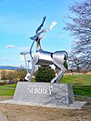
|
The Surrey Stag | Entrance to the University of Surrey campus | 2009 | Allan Sly | [31] | 51°14′29″N 0°35′43″W / 51.24139°N 0.59528°W |

|
Knife Birds | In front of the School of Management Building, University of Surrey campus | 2004 | Bridget McCrum | [31] | |

|
Narcissus | University of Surrey campus | William Pye | [31] | 51°14′34″N 0°35′18″W / 51.24278°N 0.58833°W | |

|
Thinking Of My Future | Behind Senate House, in the amphitheatre, University of Surrey campus | 2010 | Christopher Chipfuya | [31] | |
| Mural | Outside of the Lecture Theatre Block, University of Surrey campus | 1980 | Duncan Newton | [31] | ||

|
Ceramic mural | Outside of the Students’ Union, University of Surrey campus | Students at the Roehampton Institute Art Department | [31] | ||

|
Walkways | above Spine Road, University of Surrey campus | 1996 | Peter Jeffery | [31] | |

|
Spiral | in front of Postgraduate Medical School, Manor Park Campus, University of Surrey | Bridget McCrum | [31] | 51°14′21″N 0°36′45″W / 51.23917°N 0.61250°W | |

|
Triple Ripple | Manor Park Campus, University of Surrey | 2008 | Diane Maclean | [31] | 51°14′20″N 0°36′25″W / 51.23889°N 0.60694°W |

|
Acrobat | Foyer of Austin Pearce Building, University of Surrey | Natalie Staniforth | [31] | ||

|
Fish | Outside Senate House | Daren Greenhow | [31] | ||

|
Fish | Outside Senate House | Daren Greenhow | [31] | ||

|
Fish | Outside the Library | Daren Greenhow | [31] | ||

|
Charmer | Performing Arts technology studios | 2011 | Jon Edgar | [31] |
Leatherhead[]
| Image | Subject | Location | Date | Sculptor/Artist | Source | Coordinates |
|---|---|---|---|---|---|---|
| 'Bridges' Ironwork | Leatherhead High Street, Leatherhead | Unknown | Peter Parkinson, Lawrence Walker, Richard Quinnell, Lucy Quinnell | [32] | 51°17′42.8″N 0°19′46.9″W / 51.295222°N 0.329694°W | |
| Face with eyes closed | Swan Shopping Centre, Leatherhead | Unknown | Unknown | 51°17′44.6″N 0°19′40.3″W / 51.295722°N 0.327861°W | ||
| The Leatherhead Sword | Leatherhead Park, Leatherhead | Unknown | Unknown | 51°17′49.6″N 0°19′57.2″W / 51.297111°N 0.332556°W |
Molesey[]
| Image | Subject | Location | Date | Sculptor/Artist | Source | Coordinates |
|---|---|---|---|---|---|---|

|
Eights Tree | by River Thames / Tagg's Island, Molesey | 2001 | Ray Smith | [33] | 51°24′27″N 0°21′6″W / 51.40750°N 0.35167°W |
| Molesey Jubilee Drinking Fountain | Wolsey Road and Bridge Road, Molesey | 1887 (redesigned for the Diamond Jubilee of Queen Elizabeth II, 2012) | [34] | 51°24′6″N 0°20′46″W / 51.40167°N 0.34611°W |
Reigate and Redhill[]
| Image | Subject | Location | Date | Sculptor/Artist | Source | Coordinates |
|---|---|---|---|---|---|---|

|
Inglis Memorial
|
Colley Hill, Reigate | 1909 | [35] | 51°15′13″N 0°12′35″W / 51.25361°N 0.20972°W | |

|
Park Hill Monument | Reigate Hill, Reigate | 1920 | [36] | 51°13′48″N 0°12′35″W / 51.23000°N 0.20972°W | |

|
Margot Fonteyn, ballet dancer, prima ballerina | outside Watson House, London Road, Reigate | 1980 | Nathan David | [37] | 51°14′26″N 0°12′19″W / 51.24056°N 0.20528°W |
| Redland brick knot | esure, Reigate | [38] | 51°14′18″N 0°12′9″W / 51.23833°N 0.20250°W |
Runnymede[]
| Image | Subject | Location | Date | Sculptor/Artist | Source | Coordinates |
|---|---|---|---|---|---|---|

|
Magna Carta Memorial | On Cooper's Hill, Runnymede | 1957 | Edward Maufe | [39] | 51°26′40″N 0°33′58″W / 51.4445°N 0.566°W |

|
John F. Kennedy memorial | On Cooper's Hill, Runnymede | 1965 | Geoffrey Jellicoe | [40] | 51°26′41″N 0°34′07″W / 51.4447°N 0.5687°W |

|
Commonwealth Air Forces Memorial | On Cooper's Hill, Runnymede | 1953 | Edward Maufe | 51°26′16″N 0°33′54″W / 51.4378°N 0.565°W | |
| bronze statue of Queen Elizabeth II on octagonal stone base | Runnymede Pleasure Ground | 2015 | James Butler | [41] |
Staines-upon-Thames[]
| Image | Subject | Location | Date | Sculptor/Artist | Source | Coordinates |
|---|---|---|---|---|---|---|

|
Spelthorne coat of arms mosaic | High Street, middle of pedestrianised section | 2002 | Gary Drostle | [42] | 51°26′03″N 0°30′37″W / 51.4343°N 0.5104°W |

|
Gateway mosaic panels | High Street, middle of pedestrianised section | 2002 | Gary Drostle | [42] | 51°26′05″N 0°30′33″W / 51.4348°N 0.5093°W |

|
Release Every Pattern (Linoleum Workers) | High Street, west end | David Annand | [43] | 51°26′02″N 0°30′44″W / 51.4338°N 0.5121°W | |

|
The Swanmaster | Fairfield Avenue, Staines | Diane Thomson | [44] | 51°26′11″N 0°30′25″W / 51.43639°N 0.50694°W | |

|
The Swan Arches | Entrances to Memorial Gardens | Anthony and Simon Robinson, and pupils from Kingscroft Junior School (now Riverbridge Primary School) | [45] | 51°25′58″N 0°30′50″W / 51.4329°N 0.51402°W | |

|
Water Nymph statues | Memorial Gardens | 1980 (moved here 2006) | David Wynne | [45] | 51°25′58″N 0°30′51″W / 51.4327°N 0.51405°W |

|
Origami swans | Memorial Gardens | 2002 | Tom Brown | [46] | 51°25′57″N 0°30′50″W / 51.43251°N 0.5139°W |

|
London Stone (riparian) (replica) | Memorial Gardens | [45] | 51°25′57″N 0°30′51″W / 51.43255°N 0.51418°W | ||

|
The River Guardian (Heron) | At confluence of River Colne with River Thames, near Staines Bridge | Simon Buchanan | [45][43] | 51°25′59″N 0°30′56″W / 51.43295°N 0.51546°W | |

|
Pound Mill Sculpture | Wraysbury Road, Staines | John Atkin | [45] | 51°26′09″N 0°30′55″W / 51.4359°N 0.51515°W | |

|
Memorial to British European Airways Flight 548 | Waters Drive Recreation Ground | 2012 | [47] | 51°26′18″N 0°30′44″W / 51.43823°N 0.5123°W | |
| Water Sprites (combined hominid forms tapering above, exceeding head-height) | Two Rivers Shopping and Entertainment Centre | David Backhouse | [43] | |||

|
Time Continuum (sundial) | Two Rivers Shopping and Entertainment Centre | David Backhouse | [43] |
Sunbury-on-Thames[]
| Image | Subject | Location | Date | Sculptor/Artist | Source | Coordinates |
|---|---|---|---|---|---|---|

|
Lendy Memorial (lion) | The Walled Garden, Sunbury-on-Thames | 1895 (moved to current site 1986) | Local residents | [48] | 51°24′23″N 0°24′34″W / 51.4063°N 0.4095°W |

|
Cherubs | The Walled Garden | 19th century | [49] | 51°24′23″N 0°24′34″W / 51.4064°N 0.4095°W | |

|
Desert Orchid | Kempton Park, near the grandstand | 1991 | Philip Blacker | [50] | 51°25′14″N 0°24′33″W / 51.4205°N 0.4091°W |
Virginia Water[]
| Image | Subject | Location | Date | Sculptor/Artist | Source | Coordinates |
|---|---|---|---|---|---|---|

|
Totem Pole (very tall pole, carved) | In Windsor Great Park, near Virginia Water Lake (north side) | 1958 | Mungo Martin | [51] | 51°25′01″N 0°35′30″W / 51.41694°N 0.59167°W |

|
Leptis Magna Ruins (tall columns and some architraves) | As above (south side) | c. 1st century BC (placed here 1816) | [42] | 51°24′31″N 0°36′00″W / 51.40861°N 0.60000°W | |

|
Cumberland Obelisk / Prince William, Duke of Cumberland | Obelisk Pond, Windsor Great Park | commissioned 1765 | [52][53][54] | 51°25′29″N 0°35′51″W / 51.42472°N 0.59750°W |
Weybridge[]
| Image | Subject | Location | Date | Sculptor/Artist | Source | Coordinates |
|---|---|---|---|---|---|---|

|
York Column (The Monument). Stood at Seven Dials, London until 1822. | Edward Piece | 1697 | [55] |
Whiteley Village[]
| Image | Subject | Location | Date | Sculptor/Artist | Source | Coordinates |
|---|---|---|---|---|---|---|

|
William Whiteley, Copper statue on pedestal with plaques | Whiteley Village, Hersham | 1914 | George Frampton | [56] |
Woking[]
| Image | Subject | Location | Date | Sculptor/Artist | Source | Coordinates |
|---|---|---|---|---|---|---|

|
Martian tripod (aloft on slender, angular legs) | Church Street East, Woking | 1998 | Michael Condron | [57] | 51°19′14″N 0°33′25″W / 51.32056°N 0.55694°W |
| Martian cylinder | Church Street East, Woking | 1998 | Michael Condron | 51°19′14″N 0°33′25″W / 51.32056°N 0.55694°W | ||

|
Hawker Hunter | Church Street East, outside the Big Apple leisure complex | 1996, Removed July 2018 | [58] | 51°19′13″N 0°33′23″W / 51.32028°N 0.55639°W | |

|
Exchanging Luminance | Outside of The Lightbox | 2010 | Richard Jackson | [59] | 51°19′17″N 0°33′34″W / 51.32139°N 0.55944°W |

|
Lakers Life | Outside of the Lightbox | 2014 only? | Jono Retallick, George Otto, Rib Davis, Lakers Youth Centre | [60] | 51°19′17″N 0°33′34″W / 51.32139°N 0.55944°W |

|
Plaza, Orion Gate, Guildford Road | Orion Gate (columns) | 51°18′58″N 0°33′38″W / 51.31611°N 0.56056°W | |||

|
Pegasus (tall winged horse, rearing up high) | Brewery Road | 2009 | Tree Pirates | [61] | 51°19′19″N 0°33′38″W / 51.32194°N 0.56056°W |

|
bronze statue of Sir Alec Bedser bowling | next to Bedser Bridge | 2015 | Allan Sly | [62] | 51°19′17″N 0°33′36″W / 51.32139°N 0.56000°W |

|
bronze statue of Eric Bedser batting | next to Bedser Bridge | 2015 | Allan Sly | [62] | 51°19′17″N 0°33′36″W / 51.32139°N 0.56000°W |

|
Seated Man | Woking station | 2017 | Sean Henry | [63] | 51°19′09″N 0°33′24″W / 51.319127°N 0.55655837°W |

|
Standing Man | Mercia Walk | 2017 | Sean Henry | [63] | |

|
Standing Woman | Peacock Centre | 2017 | Sean Henry | [63] | 51°19′11″N 0°33′34″W / 51.319817°N 0.55930763°W |

|
Walking Woman | Victoria Square | 2017 | Sean Henry | [63] | |

|
The Wanderer | Albion Square | 2017 | Sean Henry | [63] | 51°19′08″N 0°33′27″W / 51.318842°N 0.55738986°W |

|
H G Wells | Victoria Gate | 2017 | Wesley Harland | [64] | |

|
Winning Shot | Jubilee Square | 2012 | Christine Charlesworth | [65] |
War memorials[]
| Image | Subject | Location | Date | Sculptor/Artist | Source | Coordinates |
|---|---|---|---|---|---|---|

|
Abinger Common War Memorial | Church Green Abinger Common | 1920 | Edwin Lutyens | [66] | 51°12′05″N 0°24′20″W / 51.20146°N 0.40552°W |

|
War Memorial | Ash Hill Road, Ash, Surrey | 1921 | Harold Falkner | [67] | 51°15′16.81″N 0°42′56.84″W / 51.2546694°N 0.7157889°W |

|
Ashford War Memorial | Church Road and Fordbridge Road, Ashford | 1920s | [68] | 51°25′58″N 0°27′43″W / 51.4328°N 0.462°W | |

|
Banstead War Memorial | Banstead High Street, Park Road and Sutton Lane, Banstead | 5 June 1921 | Local residents | [69] | 51°19′29″N 0°11′41″W / 51.3246°N 0.1948°W |

|
Bisley War Memorial | Guildford Road and Church Lane, Bisley | 25 September 1921 | [70] | 51°19′38″N 0°38′20″W / 51.3273°N 0.6388°W | |

|
Burpham War Memorial | Churchyard of St Marks, Burpham Lane, Burpham | 22 August 1920 | [71] | ||

|
Chertsey War Memorial | Windsor Street, Chertsey, outside the parish church of St. Peter | 1920s | Joseph Whitehead and Sons | [72] | 51°23′32″N 0°30′13″W / 51.3922°N 0.5036°W |

|
Chipstead War Memorial | Church Green, Star Lane, Hooley, near Chipstead, opposite St. Margaret's Church | 1920s | [73] | 51°17′32″N 0°09′42″W / 51.2923°N 0.1617°W | |

|
Chobham War Memorial | High Street, Chobham and Cannon Crescent | [74] | 51°20′52″N 0°36′09″W / 51.3479°N 0.60255°W | ||

|
Cranleigh War Memorial | High Street | 5 December 1920 | [75] | 51°08′31″N 0°29′30″W / 51.1419°N 0.4916°W | |

|
Dorking War Memorial | South Street | 17 July 1921 | Thomas Braddock | [76][77] | 51°13′51″N 0°20′03″W / 51.2307°N 0.3342°W |
| Epsom War Memorial | Ashley Road and Treadwell Road | 1921 | Aston Webb | [78] | 51°19′16″N 0°15′36″W / 51.32111°N 0.26000°W | |

|
Esher War Memorial | On Esher Green | [79] | 51°22′15″N 0°22′00″W / 51.3709°N 0.3667°W | ||

|
Godalming War Memorial | Riverside park below St Peter & St Paul's church | 25 September 1921 | A R Powys | [80] | 51°11′15″N 0°36′57″W / 51.1874°N 0.6159°W |

|
Guildford War Memorial | Grounds of Guildford Castle | 6 November 1921 | [81] | 51°14′3″N 0°34′18″W / 51.23417°N 0.57167°W | |

|
Post WW2 Guildford War Memorial | Grounds of Guildford Castle | 30 September 2018 | David Annand | [82] | 51°14′2″N 0°34′18″W / 51.23389°N 0.57167°W |

|
Haslemere War Memorial | Haslemere town centre | 1920s | [83] | 51°05′16″N 0°42′34″W / 51.0878°N 0.7094°W | |

|
Laleham War Memorial | Broadway and Shepperton Road, Laleham | 1920s | [84] | 51°24′33″N 0°29′25″W / 51.4093°N 0.4903°W | |

|
Leatherhead War Memorial | North Street, Leatherhead | 1920s | [85] | 51°17′45″N 0°19′50″W / 51.29591°N 0.33052°W | |

|
Molesey War Memorial | by River Thames towpath and Hurst Road | [86] | 51°24′16″N 0°20′45″W / 51.40444°N 0.34583°W | ||
| Oxted War Memorial | Church Lane, near to Station Road West | [87] | 51°15′25″N 0°0′27″W / 51.25694°N 0.00750°W | |||

|
Reigate War Memorial | Alma Road, near St. Mark's Church, Reigate | 1920s | Hicks and Charlewood | [88] | 51°14′36″N 0°12′10″W / 51.24333°N 0.20278°W |

|
Redhill War Memorial | Shaw's Corner, Redhill, near St Paul's Reformed Church | 1923 | Richard Reginald Goulden | [89] | 51°14′15″N 0°10′55″W / 51.23750°N 0.18194°W |

|
Shepperton War Memorial | Russell Road roundabout, Shepperton | 1921 | [90] | 51°23′28″N 0°27′0″W / 51.39111°N 0.45000°W | |

|
Shere war memorial | The Square, Shere | 1921 | [91] | ||

|
Staines War Memorial | Square by Old Town Hall | 1920s | [92][45] | 51°26′00″N 0°30′51″W / 51.43335°N 0.51415°W | |

|
Sunbury War Memorial | Green Street | 1920s | [93] | 51°24′41″N 0°25′03″W / 51.4115°N 0.4175°W | |

|
Walton War Memorial | High Street, Ashley Road and New Zealand Avenue | [94] | 51°23′02″N 0°25′03″W / 51.3840°N 0.4175°W | ||

|
Warlingham War Memorial | Warlingham Green | 4 December 1921 | J E Taylorsen | [95] | 51°18′35″N 0°03′21″W / 51.30965°N 0.05586°W |

|
Weybridge War Memorial | Queens Road and Hanger Hill | 1920s | [96] | 51°22′15″N 0°27′05″W / 51.3709°N 0.4513°W | |

|
Woking War Memorial | Jubilee Square. Originally at Sparrow Park. | 1920s | Francis William Doyle Jones | [97] | 51°19′12″N 0°33′31″W / 51.32000°N 0.55861°W |
References[]
- ^ Sculptures Archived 2014-08-27 at the Wayback Machine Surrey Heath BC
- ^ Public art in Surrey Heath, and a bit of a mystery Archived 2014-08-14 at the Wayback Machine Lightwater community wordpress website
- ^ "...these ladies dance?" Archived 2014-08-14 at the Wayback Machine Camberley Observed website
- ^ "Public Art shows Camberley is 'The Right Way' to go" Archived 2014-08-12 at the Wayback Machine Surrey Heath BC
- ^ "Where do elephants dance" Archived 2014-08-14 at the Wayback Machine Camberleyobserved blog
- ^ "Chobham Common History". chobham.info. Archived from the original on 2014-08-12.
- ^ "Chobham Cannon". chobham.info. Archived from the original on 2014-08-12.
- ^ Obelisk, Cranleigh Archived 2014-08-08 at the Wayback Machine britishlistedbuildings.co.uk
- ^ Jump up to: a b "About" Archived 2014-09-25 at the Wayback Machine Dorking Halls - dorkinghalls.co.uk
- ^ Tobin, Olivia (5 February 2017). "As the Dorking Cockerel celebrates its 10th birthday, we ask - why is it there?". Surrey Live. Archived from the original on 2 January 2021. Retrieved 27 December 2020.
- ^ Martin, Guy (18 July 2012). "Olympics cycling sculpture unveiled in Dorking". Surrey Live. Archived from the original on 2 January 2021. Retrieved 27 December 2020.
- ^ Younger, Rebecca (2 July 2013). "Dorking arch pays tribute to 19th Century writer". Get Surrey. Archived from the original on 12 January 2021. Retrieved 10 January 2021.
- ^ "Historic Public Artwork Installed in Dorking". Mole Valley District Council. 19 March 2021. Archived from the original on 19 March 2021. Retrieved 30 June 2021.
- ^ Jump up to: a b c d e f g h i j k l m n o p q r s t u v w Appendix B: Public art Archived 2014-08-08 at the Wayback Machine Guildford BC
- ^ Garbrand Hall – A History Archived 2014-06-13 at the Wayback Machine Local History Society epsomandewellhistoryexplorer.org.uk
- ^ John Gilpin as Spectre de la Rose Archived 2015-09-24 at the Wayback Machine Epsom and Ewell BC
- ^ "Behind The Scenes in Epsom: Unveiled at last – tribute to town's link with Classic." Archived 2016-03-05 at the Wayback Machine The Free Library thefreelibrary.com
- ^ Orlando, Jenkinson (8 June 2021). "Emily Davison statue unveiled in Epsom". Surrey Comet. Archived from the original on 22 June 2021. Retrieved 9 June 2021.
- ^ Diamond Jubilee Memorial by Francis John Williamson Archived 2013-08-26 at the Wayback Machine Victorian History Society - victorianweb.org
- ^ Queen Victoria’s Diamond Jubilee (fountain) Archived 2014-08-14 at the Wayback Machine londonbygaslight blog
- ^ Historic England. "Statue of Thomas Sutton in front of Founder's Court, Charterhouse School (1044500)". National Heritage List for England. Retrieved 29 January 2021.
- ^ Guildford and Freiburg im Breisgau coats of arms mosaic Archived 2014-08-12 at the Wayback Machine Open Plaques civic heraldry society - openplaques.org
- ^ Alice and the White Rabbit statue Archived 2014-07-27 at the Wayback Machine Surrey Life Magazine - surreylife.co.uk
- ^ Alice Through the Looking Glass Archived 2016-03-04 at the Wayback Machine Looking at Glass - lookingatglass.com
- ^ Jump up to: a b c d e f g Art in Open Spaces – Examples – One man and his dog Archived 2014-08-09 at the Wayback Machine Guildford BC
- ^ Masquerade Archived 2017-06-14 at the Wayback Machine Artist: Allan Sly allan-sly.artparks.co.uk
- ^ "White knight on a white horse" Archived 2014-08-11 at the Wayback Machine Socialquirk.co.uk
- ^ "Virtual fountain" Archived 2014-06-27 at the Wayback Machine Artist: Charlie Carter (charliecarter.co.uk)
- ^ Jabberwocky Archived 2014-08-09 at the Wayback Machine Guildford BC
- ^ Jump up to: a b c "Public Art". Guildford Borough Council. Archived from the original on 25 February 2019. Retrieved 25 February 2019.
- ^ Jump up to: a b c d e f g h i j k l m n o p q r Architecture and Public Art Archived 2012-10-25 at the Wayback Machine The University of Surrey
- ^ http://www.fireandiron.co.uk/public-art-commissions/tu2rb1hvlhq5d7bazh6x44urbuwge6
- ^ Biography: Ray Smith Archived 2014-07-27 at the Wayback Machine Public Art Online case studies – publicartonline.org.uk
- ^ A History of Molesey – Volume 3 Archived 2014-10-17 at the Wayback Machine Victoria County History, H.E. Malden and others, 1911 and later, republished by british-history.ac.uk (University of Portsmouth, History of Parliament Trust and others)
- ^ Inglis Memorial, Reigate Hill Archived 2014-06-03 at the Wayback Machine Surrey County Council
- ^ Park Hill Monument Archived 2018-12-25 at the Wayback Machine geograph.org.uk
- ^ "Marking the spot where Peggy became Margot" Archived 2016-04-13 at the Wayback Machine The Guardian theguardian.com
- ^ The Redland brick statue Archived 2014-08-12 at the Wayback Machine deeringsroad Blogspot blog
- ^ Magna Carta Memorial Archived 2015-01-24 at the Wayback Machine Runnymede 2015 800-year anniversary group - runnymede2015.com
- ^ The Runnymede Memorial Archived 2014-07-29 at the Wayback Machine Kennedy Memorial Trust - kennedytrust.org.uk
- ^ "Magna Carta: 'Fabulous' statue of Queen Elizabeth II unveiled" Archived 2015-09-24 at the Wayback Machine The website of The Surrey Advertiser Group of newspapers - getsurrey.co.uk
- ^ Jump up to: a b c Staines Mosaics Archived 2013-11-04 at the Wayback Machine Artist: Gary Drostle (drostle.com)
- ^ Jump up to: a b c d ARTwalk! The Staines Public Art Trail Archived 2016-03-04 at the Wayback Machine Spelthorne BC
- ^ "Diana Thomson - Sculptor". www.dianathomsonsculptor.co.uk. Archived from the original on 2014-05-16. Retrieved 2014-07-27.
- ^ Jump up to: a b c d e f "Staines History Walk Part 1 - Staines Historical Walks". sites.google.com. Archived from the original on 2014-08-20. Retrieved 2014-08-03.
- ^ "The Origami Swans" Archived 2014-08-11 at the Wayback Machine Ramblers' waymarking organisation - waymarking.com
- ^ Staines Air Crash Memorial Archived 2018-07-25 at the Wayback Machine geograph.org.uk
- ^ The Lendy Memorial Archived 2014-07-02 at the Wayback Machine Victorian Historical Society - victorianweb.org
- ^ Cherubs at Sunbury Walled Garden Archived 2014-08-10 at the Wayback Machine flickr.com
- ^ Desert Orchid (horse) Archived 2015-02-09 at the Wayback Machine immortalsofbritishsport.com
- ^ "Virginia Lake, The Ruins, Totem Pole and more" Archived 2014-06-27 at the Wayback Machine hampshireandsurrey.com
- ^ "Windsor Great Park and Butcher Cumberland". jjduk.blogspot.co.uk. Archived from the original on 2014-08-12. Retrieved 2014-08-12.
- ^ Cumberland Obelisk Archived 2014-08-12 at the Wayback Machine JJDUK blogspot blog
- ^ Cumberland Obelisk (section) Archived 2014-08-12 at the Wayback Machine The Crown Estate website - theroyallandscape.co.uk
- ^ Historic England. "Details from listed building database (1030168)". National Heritage List for England. Retrieved 2 April 2016.
- ^ Historic England. "William Whiteley Memorial (1030170)". National Heritage List for England. Retrieved 28 January 2021.
- ^ Martian tripod sculpture Archived 2015-12-15 at the Wayback Machine Woking BC-supported HG Wells website - thewaroftheworlds-woking.com
- ^ Hawker Hunter – Survivor XL623 Archived 2016-08-04 at the Wayback Machine Thunder and Lightnings - thunder-and-lightnings.co.uk
- ^ Exchanging Luminance by R Jackson Archived 2014-08-09 at the Wayback Machine Napa Miatke pages at photoblog.com
- ^ Our Museum Projects Archived 2014-08-14 at the Wayback Machine The Lightbox Community - wordpress website
- ^ "Pegasus arrives in Woking" Archived 2014-08-14 at the Wayback Machine Heart of Surrey community website
- ^ Jump up to: a b "Woking Bedser cricketer statues unveiled by Sir John Major" Archived 2021-06-30 at the Wayback Machine bbc.co.uk
- ^ Jump up to: a b c d e "Woking statues become permanent fixture after council buys popular artwork". Get Surrey. Archived from the original on 27 November 2020. Retrieved 2 August 2020.
- ^ "Public Art in Woking". Woking Matters. Archived from the original on 30 June 2021. Retrieved 2 August 2020.
- ^ "Christine Charlesworth (nee Fullwood) Sculptor". History Website. Archived from the original on 3 May 2016. Retrieved 2 August 2020.
- ^ Historic England. "Abinger Common War Memorial (1028839)". National Heritage List for England. Retrieved 3 September 2016.
- ^ War Memorial - Ash Archived 2018-12-24 at the Wayback Machine geograph.org.uk
- ^ Ashford War Memorial Archived 2018-10-23 at the Wayback Machine geograph.org.uk
- ^ Banstead War Memorial Archived 2014-08-08 at the Wayback Machine Bansteadhistory.com (volunteers' website)
- ^ Bisley War Memorial Archived 2018-08-23 at the Wayback Machine geograph.org.uk
- ^ Historic England. "Burpham War Memorial (1437602)". National Heritage List for England. Retrieved 27 February 2019.
- ^ War Memorial – Chertsey Archived 2014-08-10 at the Wayback Machine roll-of-honour.com
- ^ Chipstead War Memorial Archived 2014-08-12 at the Wayback Machine warmemorialsonline.org.uk
- ^ Chobham War Memorial Archived 2014-08-14 at the Wayback Machine flickr.com
- ^ War memorial Archived 2014-08-08 at the Wayback Machine theygavetheirtoday.com
- ^ "Opening of Dorking War Memorial" Archived 2014-08-08 at the Wayback Machine Dorking Museum.
- ^ Historic England. "Dorking War Memorial (1392420)". National Heritage List for England.
- ^ War Memorial Archived 2014-02-09 at the Wayback Machine Epsom and Ewell BC
- ^ GWL Magazine – War Memorials Archived 2014-08-08 at the Wayback Machine GWL Magazine gwlmagazine.com
- ^ "Godalming war memorial rededication". Godalming Town Council. Retrieved 16 September 2019.
- ^ War Memorial - Guildford Archived 2015-09-24 at the Wayback Machine queensroyalsurreys.org.uk
- ^ "New war memorial unveiled in Guildford". Surrey Chambers of Commerce. Archived from the original on 17 January 2019. Retrieved 16 January 2019.
- ^ Haslemere – War Memorial Archived 2014-08-10 at the Wayback Machine warmemorialsonline.org.uk
- ^ War Memorial - Laleham Archived 2021-01-24 at the Wayback Machine UKNIWM.org.uk
- ^ War Memorial - Leatherhead Archived 2013-11-10 at the Wayback Machine ukattraction.com
- ^ War Memorial - East and West Molesey Archived 2014-07-28 at the Wayback Machine tracesofwar.com
- ^ War Memorial - Oxted Archived 2014-08-08 at the Wayback Machine ukattraction.com
- ^ Reigate – War Memorial Archived 2014-08-08 at the Wayback Machine the War Memorials Trust - warmemorials.org
- ^ War Memorial - Redhill Archived 2013-11-11 at the Wayback Machine ukattraction.com
- ^ War Memorial - Shepperton Archived 2014-08-12 at the Wayback Machine roll-of-honour.com
- ^ "Archived copy". Archived from the original on 2019-03-31. Retrieved 2020-08-06.CS1 maint: archived copy as title (link)
- ^ "Staines War Memorial". Archived from the original on 2014-08-10. Retrieved 2014-07-30.
- ^ "Sunbury on Thames War Memorial". Archived from the original on 2014-08-10. Retrieved 2014-07-31.
- ^ War Memorial - Walton-on-Thames Archived 2013-11-09 at the Wayback Machine ukattraction.com
- ^ War Memorial - Warlingham Archived 2021-01-24 at the Wayback Machine UKNIWM.org.uk
- ^ Weybridge - War Memorial Archived 2016-03-05 at the Wayback Machine warmemorialsonline.org.uk
- ^ War Memorial – Woking – World War I Archived 2014-08-08 at the Wayback Machine windowonwoking.org.uk
| show Public art and memorials in the United Kingdom |
|---|

- Lists of public art in England
- Buildings and structures in Surrey
- Tourist attractions in Surrey
- Outdoor sculptures in England