Staines-upon-Thames
| Staines-upon-Thames | |
|---|---|
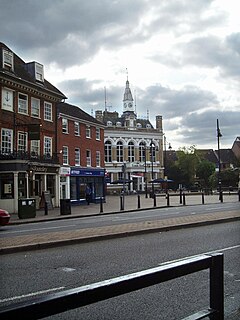 Clarence Street and The Town Hall[a] | |
 Staines-upon-Thames Location within Surrey | |
| Area | 7.86 km2 (3.03 sq mi) |
| Population | 18,484 (2011 Census, traditional boundaries)[2] or 25,736 (Built-up Area, which includes Laleham)[3] |
| • Density | 2,352/km2 (6,090/sq mi) |
| OS grid reference | TQ045715 |
| District | |
| Shire county | |
| Region | |
| Country | England |
| Sovereign state | United Kingdom |
| Post town | STAINES-UPON-THAMES[4] |
| Postcode district | TW18-19 |
| Dialling code | 01784 |
| Police | Surrey |
| Fire | Surrey |
| Ambulance | South East Coast |
| UK Parliament | |

Staines-upon-Thames is a town on the left bank of the River Thames in Surrey, England, in the borough of Spelthorne. At or near the Roman settlement of Pontibus, it became Stanes and then Staines. Its borough is in the historic county of Middlesex and its two precursor districts were transferred to Surrey County Council in 1965.
The town is inside the M25 motorway, 17 miles (27 km) southwest of Charing Cross. Situated in the far north of Surrey, it is within the London Commuter Belt and the Greater London Urban Area, and adjoins part of the Green Belt. Passing along the edge of the town and crossing Staines Bridge is the Thames Path National Trail. The bridge is one of many re-buildings. It was built from 1827–1832, to white granite-faced designs by George Rennie.
The larger Staines-upon-Thames post town includes the villages of Stanwell, Laleham and Wraysbury. Owing to the long association of Staines Bridge with a medieval causeway (levee) on the opposite bank of the river, the post town also includes part of Egham Hythe. This contains a significant business zone of the county and, in its east, a few of the town's oldest listed buildings.
Staines-upon-Thames has many parks, leisure centres, a football club and several multinational research/technology company offices. The centre of Heathrow Airport is 3 miles (5 km) to the north-east and Staines railway station is a main stop on the London Waterloo to Reading line and the Windsor & Eton Riverside line.
The traditional boundaries are unusual for a South-East town, being a north–south strip parish that ranges from 13 to 20 metres (43 to 66 ft) above sea level.[b]
Name[]
The name derives from Middle English stanes, from Old English stānas ("stones").
History[]
Early history[]
A neolithic causewayed camp has been found at the south of Yeoveney on Staines Moor. This had later prehistoric, Roman, and Saxon occupation.[5]
At the site of Majestic House excavations in 2013 revealed evidence of intermittent human activity over many centuries.[6] Residual flint artefacts of Mesolithic and Neolithic date, and a small number of Neolithic/Bronze Age features including postholes, were found.[6] The most significant prehistoric evidence was the remains of a ring ditch of that era, a monument type rarely recorded locally.[6] A small Iron Age artefact assemblage was found, as was evidence for drainage ditches from those Mesolithic/Neolithic times.[6] Drainage and boundary ditches formed much of the evidence for later activity on the site, which is east of the later centre of the town but close to the line of the Roman road.[6] Roman occupation debris and agricultural features of 2nd–3rd century AD date were found, and there was a suggestion of continuity of occupation into the 4th century AD. There was no evidence for Saxon or early medieval activities, but the remains of later medieval rectilinear buildings, a well and ditches were found.[6] Ellis (2013) draws a map of this site at the heart of a town island, rather a perennially non-marshy, rounded (penannular) zone that has five archaeological sites.[6]
There has been a crossing of the Thames at Staines since Roman times. The emperor Claudius invaded Britain in AD 43. Staines had the zone mentioned above, likely remaining settled, at that time. Within a decade, some sort of first Staines Bridge would have been needed for the Roman road much later known in places as the Devil's Highway, elsewhere as the stone ('stane') street between Londinium (London) and Calleva Atrebatum (Silchester).
Pontibus, Latin for "at the bridges" in the early 3rd-century Antonine Itinerary, has long been guessed to refer to Staines, but that may be wrong since the Itinerary's mileages actually point some distance away (possibly to the south end of Virginia Water Lake). More than one bridge might have traversed Church Island.[7] Ad Pontem was an altogether different place.

The Middlesex section of the Domesday Book records the manor "Stanes" as a property held by Westminster Abbey. It was stated to have 19 hides of land and had 6 mills worth £3, 4s, 0d; 2 weirs worth 6s, 8d; 24 ploughs; meadows for 24 ploughs; and some cattle. It rendered £35.[8]
A boundary stone dated 1285 used to stand on the bank of the River Thames in Staines, indicating the western limit of the City of London's jurisdiction over the Thames. The original stone is now located in the Spelthorne Museum[9][10] and a replica is situated in Lammas Park. Although familiarly known as the 'London Stone', it is not to be confused with the more famous – and probably more ancient – London Stone in Cannon Street in the City of London.
The barons assembled at Staines before they met King John at Runnymede in 1215, and Stephen Langton held a consecration there shortly after the sealing of Magna Carta. Kings and other important people must have passed through the town on many occasions: the church bells were rung several times in 1670, for instance, when the king and queen went through Staines.[11] Between 1642 and 1648 during the Civil War, there were skirmishes on Staines Moor and numerous troop movements over Staines Bridge. The parish remained largely agricultural until the mid-19th century.[11]
Modern history[]
Boundaries[]
In the 19th century the Church of England lost all its secular maintenance and relief functions, of its vestries. However, as local government became unparished, the parish boundary of Laleham remains used in road signs and official naming, notable as its housing has become widely contiguous.
Ashford, receiving from Staines the River Ash, had its boundary running north from the mid-part of Kingston Road, south of which lay part of Laleham which zig-zagged further west.[12]
Laleham remains, as it was in the mid-19th century, a long tranche beginning east of the north-south Sweep's Ditch which runs south to the tip of the Penton Hook peninsula of the River Thames. Spelthorne Borough Council is one of the few Surrey districts divided completely equally in terms of number of councillors per wards yet the population of Laleham is insufficient to elect three councillors. Laleham does share a post town, and has a large sports ground named after Laleham and Staines. It instead forms one half of the ward Riverside [Staines] and Laleham, parts A and D of Spelthorne's 009 division in the United Kingdom Census 2011.[13]
Stanwell in 1896 lost 70 acres (28 ha) with 122 houses, to Staines, north of London Road.[13][14]
Early economy[]
Staines was a regular staging post with coaching inns. It was used for an overnight horse change on The Trafalgar Way in 1805, announcing the victory over the combined French and Spanish fleet and the death of Nelson.[15] Samuel Lewis mentions the place in his 1848 Topographical Dictionary of England, saying that "The town, which has been much improved of late, consists principally of one wide street, containing several good houses, terminating at the river."[16]
Industries[]

The town was a major producer of linoleum after the formation of the Linoleum Manufacturing Company in 1864 by its inventor, Frederick Walton. Linoleum became the main industry of the town and was a major employer in the area until the 1960s. In 1876 about 220 and in 1911 about 350 people worked in the plant. By 1957 it employed some 300 people and in 1956 the factory produced about 2675 m2 of linoleum each week. The term 'Staines Lino' became a worldwide name but the factory was closed around 1970 and is the site is now occupied by the Two Rivers shopping centre, completed about 2000. A bronze statue of two lino workers in Staines High Street commemorates the Staines Lino Factory. The Spelthorne Museum has a display dedicated to the Linoleum Manufacturing Company.
The Lagonda car factory was on the site of Sainsbury's supermarket in Egham Hythe.[17]
Notable events[]
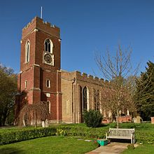
The town was the site of the Staines air disaster in 1972, at the time the worst air crash in Britain until the Lockerbie disaster of 1988. (Since the Lockerbie crash was a terrorist act in Scotland, the Staines crash remains England's worst air disaster, and Britain's worst air accident.) The crash was commemorated in June 2004 by the opening of a dedicated garden near the crash site, created at the request of relatives, and the unveiling of a stained glass window at St Mary's Church, where a memorial service was held.[18]
Staines Urban District[]

In 1894 the Local Government Act 1894 created the Staines Urban District. This status conferred additional powers and responsibilities compared with the few Rural Districts in Middlesex County Council. In 1965, under the London Government Act 1963, Middlesex, apart from the Staines, Sunbury-on-Thames and Potters Bar Urban Districts, became part of Greater London. Staines and Sunbury were transferred to Surrey and Potters Bar to Hertfordshire. In 1974, under the Local Government Act 1972, the Staines Urban District was combined with Sunbury-on-Thames Urban District to form the present-day borough of Spelthorne. Staines remains associated with the historical county of Middlesex through certain cultural and sporting affiliations, and until 1996 for postal purposes.
Staines-upon-Thames[]
The town changed its official name to "Staines-upon-Thames" on 20 May 2012.[19]
On 15 December 2011, Spelthorne Borough Council resolved by 25 votes to 4[19] with 6 abstentions (including all the councillors for Staines ward itself)[20][21] to change the name of the town to Staines-upon-Thames, to try to boost the local economy by promoting its riverside location, and reportedly to discourage association with Sacha Baron Cohen's fictional character Ali G, as well as rock band Hard-Fi, who described Staines as "a ghost town".[19][22][23]
The name change proposal originated with Spelthorne Business Forum.[24] 428 responses to a public consultation were in favour and 234 opposed,[25] but there were some public objections,[26] including one from Staines Town Football Club which attempted to present 134 signatures to the council, but they were not received.[19][25] Adopting the name change, the council resolved to call on residents, businesses and public organisations to use the name Staines-upon-Thames, and to call on Surrey County Council and Runnymede Borough Council to use Staines-upon-Thames for all official business.[20] Following a day of celebrations in the town, including a regatta on the river, the Lord Lieutenant of Surrey, Dame Sarah Goad DCVO, formally changed the name on 20 May 2012 at 2 pm.[22] Royal Mail adopted the new name in mid-2013,[4] having previously stated that the name would remain as Staines on the Postcode Address File.
Economy[]
Proximity to London, Heathrow Airport and the M25 motorway has attracted large company branch offices, including: Bupa (healthcare)[27] and Wood plc (oil & gas).[28] Siemens Building Automation Division and British Gas (part of Centrica) have their national headquarters here.[29] Samsung R&D Institute UK (SRUK), Samsung's UK R&D division, is based in the town.[30]
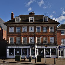
The town centre is compact save for more niche businesses and leisure-oriented west ends (Church Street and the river's banks). It has a wide pedestrianised High Street where a long market is held every Wednesday, Friday and Saturday. Behind its shops a moderately-sized shopping centre, Elmsleigh Centre faces a retail park, behind the other side. The Two Rivers retail park opened in 2002, its far edge sees the return of the Wraysbury River into Colne. Staines has at least three parades of convenience shops and local professional services. The town has many central restaurants. A range of pubs host live music evenings.
Architecture and landmarks[]

The original manor of Staines became derelict and was demolished. Staines Bridge spans the Thames with a three arch structure completed in 1832. Until the 14th century, Staines was the tidal limit, but this is now downstream at Teddington – a replica London Stone exists in the Lammas Recreation Ground.
The administrative offices of Spelthorne Borough Council are by one of the town's more linear parks. In the early 2000s, a public landscape area was constructed by the riverside conservation area with seating and sculptures to enhance the waterfront as a place to walk. Staines Town Hall is a stuccoed Victorian blend of Italian and Flemish styles in a small market square, converted into an Art Centre in the 1990s, and later turned into a pub (now closed). Elaborate Georgian shophouses line Clarence Street (named after William, Duke of Clarence, who became King William IV).[31] Church Street and Lammas Lane house the oldest properties clustered around the parish church of St Mary.[32] Most neighbourhoods have green spaces such as (Staines Moor, Shortwood Common, Knowle Green, Leacroft, the Lammas and the sports fields and farms on the borders of Laleham. The last two are riverside parks with picnic areas and playgrounds. Many of the parks belonged to former grand houses: see Laleham for Lord Lucan's 'Laleham House' which became a Roman Catholic abbey for a century. Since the late 20th century, listed luxury apartments in the post town have been created there and at Duncroft Manor.
Staines Bus Garage opened June 1936 and was an extremely sinuous-looking design when viewed from the garage's approach road, with curved runs of offices either side of the garage forecourt, and canopies on the circular stub towers at the ends of the office blocks describing almost three-quarters of a circle. It closed in 1996 and the site is occupied by Offices, there are no remains of the Garage.
Twinning[]
This section does not cite any sources. (November 2020) |
Staines is Twinned with
- Melun (France) 1990
- Grand Port (Mauritius) 2009
Education[]
The town has the following schools:
- Our Lady Of the Rosary, a Catholic school, opened in 1893
- Staines Preparatory School, an independent, ages 3–11 school, opened in 1935
- Matthew Arnold School, properly opened in 1954, though partially completed premises were also in emergency use during the Second World War
- Riverbridge Primary School,[33] formed in September 2011 from the merger of three local schools: Kingscroft, Knowle Park and Shortwood, each of which retained its original site; however, the Shortwood site has now closed
- The Magna Carta School, a technology college with over 1200 students. It was opened in 1957, and is in Egham Hythe, but it has a Staines postal address.
- The Buckland primary school.
Several other schools have previously existed in the town, including:
- British School (Staines's first school opened in 1808; date of closure unknown)
- National Girls' School (1818–c.1825, 1844–1874, 1885–?)
- National Boys' School (c.1823–c.1830 and 1848–1874)
- British School of Industry for Girls (pre-1831–?) at The School House in Hale Street[34][35]
- British Infant School (1833–1874 and 1885–?)
- Margaret Pope School, a merger and relocation of three previous schools (1874–?) This was as a result of a School Building Grant Application for Miss Pope's school[36]
- Church of England Infants' School, Stanwell New Road (from 1890, renamed Shortwood in 1900)
- Shortwood County Infant School (renamed from C. of E. Infants' in 1900, merged into Riverbridge 2011)
- Wyatt Road Infants' School (1896–1974)
- Kingston Road School[s] (1903–1992 when replaced by Kingscroft; the original plural title denoted that there were separate schools for boys and girls; its site is now occupied by the town's new Police Station)
- Knowle Park County First School (1974–2011 when merged into Riverbridge)
- Kingscroft School (replaced and absorbed Kingston Road in 1992, merged into Riverbridge in 2011)
The nearest further education institution to Staines is Brooklands College (formerly Spelthorne College) in neighbouring Ashford, about 3 miles to the east. Royal Holloway, University of London is 3 miles west of the town centre, off the A30 between Egham and Englefield Green.
Margaret Pope was daughter of Dr Robert Pope (Physician to King George III and Princess Amelia)[37] and lived in Staines High Street. Margaret started the Margaret Pope's Educational Charity which still exists as registered charity 311907.[38]
Sport[]

Two affiliated senior association football clubs bear the name of Staines, namely Staines Town F.C. (senior status), and Staines Lammas F.C. (intermediate status). Staines Town plays at the newly rebuilt Wheatsheaf Park ground and is a member of Isthmian League Premier Division. Staines Town has a strong rivalry with Hampton & Richmond Borough F.C.. Staines Lammas was champion of the Combined Counties League Division One in the 2007–08 season.the club runs various age group teams. Staines also has several successful junior football clubs: Staines Town, Staines Lammas and Staines Albion, as well as girls' clubs Kempton Girls FC — Colne Valley and the U11, one of the best girls' junior clubs in Surrey.
Staines Rugby Football Club[39] used to play at the Lammas (a recreation ground in the town also known as the Ashby Recreation Ground). The club moved to The Reeves (on Snakey Lane, Hanworth) in the 1960s but kept its name. It has teams named Swans, Cobs and Mucky Ducks. The club is in Herts/Middlesex 1 league and has mini and youth sections.
Staines Boat Club is immediately across the bridge in Egham Hythe and competes at a national level.
Staines Hockey Club was formed in 1890, making it one of the oldest hockey clubs in the world. Its early years were very illustrious with several internationals playing for the club and a number of gold medals being won by Staines members in the 1908 Olympic Games. The club is based at Worple Road, Staines - the club has adult and junior teams playing hockey today.[40]
Staines Swimming Club[41] founded in the early 1900s and affiliated to the Amateur Swimming Association is based at Spelthorne Leisure Centre and provides competitive swimming from inter-club level up to national level.
Spelthorne Volleyball Club, also based at Spelthorne Leisure Centre, provides volleyball to a wide range of abilities and age groups.
Clubs in the borough cater to sailing, cricket, hockey, running, rambling, martial arts (jujitsu), rifle & pistol shooting, bowls, chess, bridge, snooker, darts, pool, poker, and a district table tennis league.
The town is also home to TS Thamesis, Staines and Egham Sea Cadet Corps. This is a uniformed youth organisation for young people aged between 10 and 18 years old. It meets at The Lammas.
Historic sports[]
Motorcycle speedway racing was staged at a stadium in Wraysbury Road. Events in 1938 and 1939 are well-known, but it is possible that a venue was active from at least 1931, for a team named Staines raced at Caxton Speedway (near Cambridge, 1931 – 1933 inclusive). The stadium was also used for greyhound racing, as well as 'novelty' events such as cheetah racing.
Staines Stadium was famous from 1955 to 1960 during the early days of stock car racing in England, and featured in the 1955 feature film Stock Car among others.[42]
Other sports formerly held in Staines include: boxing (there were weekly programmes off the High Street in the 1930s, and local hearsay suggests bare-knuckle events were held at the Crooked Billet earlier in the 20th century); wrestling (bouts were included in boxing programmes of the 1930s); motorcycle football (a club existed in the 1960s; and American football (a short-lived team called Staines Removers entered the Budweiser League in 1988, but failed to start the season, although they did play some friendly matches at their base on The Lammas).
Transport[]
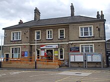
Staines railway station is a stop on all services between London Waterloo station and Weybridge (for the South West Main Line), Reading (for the Great Western Main Line) and Windsor & Eton Riverside. Semi-fast services serve the Waterloo to Reading Line, being the operator's secondary main line. Taxis are available from the station. The bus station is a five-minute walk from the railway station, with services in all directions including to Thorpe Park and Royal Holloway College. Staines-upon-Thames is also a short distance south of Heathrow Airport.
Rail infrastructure projects[]
There were proposals to build a new railway line, Airtrack, connecting the South West Main Line and/or London Gatwick to Heathrow Airport's Terminal 5 station. As part of these proposals, the former Staines High Street railway station was to be rebuilt by Two Rivers Shopping Centre and the High Street in the direction of Wraysbury railway station, using a generally unused arc from north to south in the town centre, towards Weybridge on the South West Main Line. In 2011 the Department for Transport announced it had decided that this would not proceed because extra trains would delay road traffic using the level crossing at Egham. The existing Staines station would have an additional platform built instead on the relevant arc.[citation needed]
Demography and housing[]
| Output area | Detached | Semi-detached | Terraced | Flats and apartments | Caravans/temporary/mobile homes | shared between households[2] |
|---|---|---|---|---|---|---|
| Staines (ward) | 387 | 844 | 843 | 1,439 | 2 | 13 |
| Staines South (ward) | 197 | 1,505 | 702 | 492 | 1 | 2 |
| Spelthorne 009B (riverside north) | 174 | 225 | 93 | 365 | 0 | 5 |
| Spelthorne 009C (riverside south) | 369 | 96 | 109 | 148 | 1 | 0 |
The average level of accommodation in the region composed of detached houses was 28%, the average that was apartments was 22.6%.
| Output area | Population | Households | % Owned outright | % Owned with a loan | hectares[2] |
|---|---|---|---|---|---|
| Staines (ward) | 7,861 | 3,528 | 24.0% | 33.8% | 550 |
| Staines South (ward) | 7,123 | 2,899 | 29.9% | 37.7% | 131 |
| Spelthorne 009B (riverside north) | 1,818 | 862 | 37.6% | 37.5% | 35 |
| Spelthorne 009C (riverside south) | 1,662 | 723 | 51.5% | 39.1% | 70 |
The proportion of households in the town who owned their home outright compares to the regional average of 35.1%. The proportion who owned their home with a loan compares to the regional average of 32.5%. The remaining % is made up of rented dwellings (plus a negligible % of households living rent-free).
Nearest places[]
Neighbouring towns and villages are Egham, Wraysbury, Ashford, Stanwell, Laleham and Chertsey. About 3 miles north east of Staines-upon-Thames is Heathrow airport. The area across the Thames between Egham and Staines-upon-Thames town centres is a ward called Egham Hythe.
Notable residents[]
- All Alone, important war pigeon
- Richard Archer, musician
- B. H. Barry, fight director
- Danny Blanchflower, former captain of Tottenham Hotspur F.C.
- Bobby Davro, comedian
- Hard-Fi, indie rock band
- Charles Wellington Furse, portrait and figure artist
- Steve Holley, musician
- Norman Hunter, author
- Dan Jones, writer, historian
- Christine Keeler, actress/showgirl involved in the Profumo affair
- Denny Laine, musician
- Matt Lapinskas, actor
- Richard Murdoch, comedian, after whom Murdoch Close in the town is named.
- Bill Nankeville, athlete
- Geoffrey Molyneux Palmer, composer
- Dick Pepper, musician and writer
- Jon Tickle, television personality
- Nina Wadia, actress
Local media[]
Such newspapers are or were, mainly, the:
- Staines Informer
- Surrey Herald
- Staines and Ashford News
- Staines and Egham News
Notes[]
References[]
- ^ "Ordnance Survey". Archived from the original on 24 April 2012. Retrieved 27 November 2018.
- ^ Jump up to: a b c Key Statistics; Quick Statistics: Population Density Archived 11 February 2003 at the Wayback Machine United Kingdom Census 2011 Office for National Statistics Retrieved 21 November 2013
- ^ UK Census (2011). "Local Area Report – Staines Built-up area sub division (1119885023)". Nomis. Office for National Statistics. Retrieved 15 August 2020.
- ^ Jump up to: a b "New sectors and localities to 20 July 2012" (PDF). Royal Mail Address Management Unit. 20 July 2012. Archived from the original (PDF) on 11 December 2013. Retrieved 28 October 2012.
- ^ Excavations at Yeoveney, Near Staines, 1982 Phil Jones, Martin O'Connell and Rob Poulton https://archaeologydataservice.ac.uk/archiveDS/archiveDownload?t=arch-379-1/dissemination/pdf/vol_80/surreyac080_105-119_jones.pdf Archived 22 January 2021 at the Wayback Machine
- ^ Jump up to: a b c d e f g Surrey Archaeological Collections, 99, 129–148, 2016 "Archaeological investigation at Majestic House, High Street, Staines-upon-Thames 2013". Abstract. Chris Ellis, with contributions by Philip L Armitage, Michael Bamforth, Sarah Cobain, E R McSloy and Jacky Sommerville https://archaeologydataservice.ac.uk/archiveDS/archiveDownload?t=arch-379-1/dissemination/pdf/vol_99/surreyac099_129-148_ellis.pdf Archived 22 January 2021 at the Wayback Machine
- ^ Thacker, Fred. S. (1968) [1920]. The Thames Highway. II: Locks and Weirs. Newton Abbott: David & Charles. SBN 7153-4233-9.[page needed]
- ^ "Middlesex". The Domesday Book Online. Archived from the original on 29 October 2015. Retrieved 28 October 2015.
- ^ "London Stone Spelthorne". Exploring Surrey's Past. Retrieved 18 March 2021.
- ^ "Exhibits". Spelthorne Museum. Retrieved 18 March 2021.
- ^ Jump up to: a b Reynolds, Susan, ed. (1962). "Staines: Introduction". A History of the County of Middlesex. Victoria County History. III. University of London Institute of Historical Research. pp. 13–18. Archived from the original on 12 September 2015. Retrieved 4 February 2006.
- ^ "Explore georeferenced maps - Map images - National Library of Scotland". Archived from the original on 6 October 2020. Retrieved 27 September 2020.
- ^ Jump up to: a b Reynolds, Susan, ed. (1962). "Staines: Introduction The hundred of Spelthorne (continued)". A History of the County of Middlesex. Victoria County History. III. University of London Institute of Historical Research. pp. 13–18. Retrieved 11 December 2013.
- ^ Vision of Britain - Historic units of land - civil parishes - Stanwell - boundary changes Archived 14 August 2020 at the Wayback Machine University of Portsmouth and Others.
- ^ Commemorated on a plaque in Staines Town Hall, a pub-restaurant
- ^ Lewis, Samuel, ed. (1848). "Staines". A Topographical Dictionary of England. London: University of London Institute of Historical Research. Archived from the original on 8 September 2015. Retrieved 25 November 2012.
- ^ "From Sainsbury's to the Sarthe | Motor Sport Magazine Archive". Motor Sport Magazine. 7 July 2014. Archived from the original on 16 October 2019. Retrieved 16 October 2019.
- ^ "Memorial garden to commemorate Heathrow disaster". This Is Local London. Archived from the original on 16 October 2019. Retrieved 16 October 2019.
- ^ Jump up to: a b c d "Staines-upon-Thames renaming decision made". 16 December 2011. Archived from the original on 10 January 2012. Retrieved 16 December 2011.
- ^ Jump up to: a b Spelthorne Council Minutes 15 December 2011[dead link]
- ^ Spelthorne Borough Councillors by ward 2011–2015 Archived 23 February 2012 at the Wayback Machine
- ^ Jump up to: a b "Staines becomes Staines-upon-Thames to shake off Ali G link". BBC. 20 May 2012. Archived from the original on 21 May 2012. Retrieved 20 May 2012.
- ^ "Staines rebrands to escape stain of Ali G". the Guardian. 20 May 2012. Retrieved 21 July 2021.
- ^ "Business leaders back Staines name change". Surrey Advertiser. Trinity Mirror. 6 June 2011. Archived from the original on 12 June 2011. Retrieved 20 May 2012.
- ^ Jump up to: a b "Staines set to rebrand as Staines-upon-Thames". Surrey Advertiser. Trinity Mirror. 23 November 2011. Retrieved 20 May 2012.
- ^ "Staines-upon-Thames 'sounds like pollution'". Surrey Advertiser. Trinity Mirror. 30 November 2011. Retrieved 20 May 2012.
- ^ "Archived copy". Archived from the original on 22 January 2021. Retrieved 27 September 2020.CS1 maint: archived copy as title (link)
- ^ "Wood PLC, Compass Point, 79-87 Kingston Road, Staines-upon-thames, Middlesex, TW18 1DT". Archived from the original on 22 January 2021. Retrieved 27 September 2020.
- ^ "See all our locations in the UK and Republic of Ireland" (PDF). Centrica. 29 June 2015. Archived from the original (PDF) on 1 March 2016. Retrieved 18 February 2016.
3. British Gas Head office, The Causeway, Staines
- ^ "SR United Kingdom". Samsung Research. Samsung. Archived from the original on 19 October 2020. Retrieved 20 September 2020.
- ^ "Planning". Spelthorne Borough Council. Archived from the original on 26 April 2012. Retrieved 11 December 2012.
- ^ "OS Maps Online". Ordnance survey. Archived from the original on 29 October 2013. Retrieved 11 December 2012.
- ^ "Riverbridge Primary School". Riverbridge Primary School. Archived from the original on 22 January 2021. Retrieved 20 May 2012.
- ^ "Staines: Schools | British History Online".
- ^ England Census 1861 Staines Middlesex District 10 entry 192
- ^ Treasury and Committee of the Privy Council on Education:Building grant application Reference:ED 103/130/16. Description School Building Application for Staines [Miss Margaret Pope's] British School, Middlesex. School number 10403. Page 289 Held by National Archives at Kew
- ^ Letter from Princess Amelia in Royal Trust Collection https://gpp.rct.uk/Record.aspx?src=CalmView.Catalog&id=DOCUMENTARY%2f40&pos=1
- ^ "MARGARET POpe's EDUCATIONAL CHARITY - Charity 311907".
- ^ "Welcome to Staines Rugby". Staines Rugby Club. Retrieved 20 May 2012.
- ^ Staines Hockey Club
- ^ "Staines Swimming Club". Staines Swimming Club. Retrieved 20 May 2012.
- ^ Marsh, Peter (14 May 2008). "Racing at Staines". Pete's Stoch Car Pages.
External links[]
| Wikimedia Commons has media related to Staines-upon-Thames. |
- Chisholm, Hugh, ed. (1911). . Encyclopædia Britannica. 25 (11th ed.). Cambridge University Press. p. 760.
- Staines-upon-Thames at Curlie

| show Authority control |
|---|
- Staines-upon-Thames
- Towns in Surrey
- Market towns in Surrey
- Places formerly in Middlesex
- Populated places on the River Thames
- Unparished areas in Surrey
- Borough of Spelthorne