List of show caves in Germany

The list of show caves in Germany contains all 51 show caves in Germany which are hosted by the German Speleological Federation. (German: Verband der Deutschen Höhlen- and Karstforscher)
Background[]
As of 2008, there have been 51 show caves in Germany, which are hosted by the German Speleological Federation (German: Verband der Deutschen Höhlen- and Karstforscher).[1] A show cave is defined as any cave equipped for tourists, by having walkways or steps, fitted with lighting, or supplying gear, as examples. Show caves have regular opening times, usually with regular guided tours of about 30 to 45 minutes duration and are almost all electrically lighted. Only the Easter Cave and the Schellenberg Ice Cave still use carbide lamps. In 1884 the was the first German show cave to be equipped with electrical lighting and the second in the world to be thus fitted. Only the in the Styria in Austria was equipped earlier, in 1883.
Not included on this list are the artificially created caverns and Saalfeld Fee Grottos, although these are listed with the German Speleological Federation, as their operators are paying members.
Also not in the main list is Balve Cave, because it has no regular guided tours or visits. Included is the , which is not part of the German Speleological Federation, but fulfils all the conditions of a show cave.
The cave which had the first guided tours was Baumann's Cave in the Rübeland; Tours of this cave were organised as early as 1646 and it was visited by Goethe. The latest to be opened as a show cave was the in 2009.
More than half the show caves are dripstone caves. The Wimsen Cave is the only show cave in Germany accessible by boat, for a distance of 70 metres. The is the only fissure cave in the list and the largest publicly accessible cave in Europe. The is the only shaft cave that can be viewed in Germany, having a depth of 55 metres below the entrance and reaches the greatest depth of any German show cave. The Schellenberg Ice Cave is the only ice cave in Germany that can be visited. In the Barbarossa Cave, which is formed of anhydrite stone, loose layers of plaster hang like wallpaper from the ceilings and walls.
Legend[]

- Name of the show cave : states the name of the show cave.
- Location: gives the location of the show cave.
- State: gives the state in which the show cave is found.
BR
BE
BW
BY
HE
Brandenburg
Berlin
Baden-Württemberg
Bayern
Hesse
MV
NI
NW
RP
SH
Mecklenburg-Vorpommern
Lower Saxony
North Rhine-Westphalia
Rhineland-Palatinate
Schleswig-Holstein
SL
SN
ST
TH
- Location: gives the coordinates of the show caves.
- Geological classification: states the geological type of cave. It may be a limestone cave, rock cave, karst cave or other type.
- Length (m): gives the total length of the show cave in metres including all branches.
- GR (m): gives the total length of the guided route in metres, ignoring any doubling of walkways. It does include any artificial access walkways that are not part of the total length of the cave. So the guided route may be longer than the total length of the cave.
- Height: gives the height of the entrance above sea level.
- Discovery: is the date of discovery of the show cave. Most show caves were known by the local population much earlier, because they sometimes had a natural entrance accessible on foot. In these cases the year the cave is first mentioned in the records is shown in brackets.
- Show caves : gives the start of its operation as a show cave. Subsequent problems with safety, the impact of war, financial issues or changes of owner may have led to long interruptions in its use as a show cave.
- Electr. Light: states the year when electrical lighting was first installed.
- Visitors (annual): gives the latest (2004 to 2008) average, annual visitor numbers. If the number is in brackets it indicates the recent, average number of visitors, over a different, unspecified period.
Table[]

Disputed caves[]
Several caves are sometimes described in the literature as show caves, although they do not meet the criteria. These include the Saalfeld Fairy Grottoes and which are not natural caverns, but mines, and the and the Balve Cave, which have no regular guided tours.
| Name of show cave |
Location | State |
Geological classification | Len- gth (m) |
GR (m) |
Dis- cov- ery |
Show- Cave |
Electr. Light |
Visi- tors (/yr) |
|---|---|---|---|---|---|---|---|---|---|
| Balve Cave | Balve | NRW | Large rock cave | 138 | 138 | (1690) | |||
| Morassina | Schmiedefeld | TH | Dripstone filled show mine | 2000 | tbd. | 1683 | 1993 | 1993 | tbd. |
| Saalfeld Fairy Grottoes [note 3] | Saale | TH | Dripstone filled show mine | 1100 | 600 | 1913 | 1914 | 1914 | 175,000 |
| [note 4] | Homburg | SL | Mine in Bunter sandstone | 5000 | 800 | (1708) | 1930 | 1935 | 33,500 |
| [note 5] | Zwiefaltendorf | BW | Primary cave in tufa | 27 | 27 | 1892 | 1892 |
Gallery[]
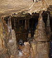
Stalagmites in the Bing Cave

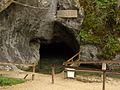
Entrance area of the Schellenberg Ice Cave
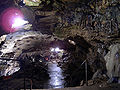
Entrance to the Wimsen Cave
Syrauer Dragon Cave
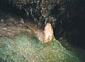
The Nebel Cave

Stalagmite group in the Teufel's Cave near Pottenstein


See also[]
References[]
- ^ "Schauhöhlen". Verband der Germann Höhlen- and Karstforscher e.V. Retrieved 12 August 2008.[dead link]
Notes[]
- ^ Marienglas Cave – a former mine with a natural cavern, the so-called Gipskristalldruse or Crystal Grotto (Kristallgrotte). This crystal grotto is the main attraction of the mine, which is why it is viewed more as a show cave. – Although the literature overwhelmingly sees it as a show cave, it calls itself a show mine.
- ^ Tufa caves (tuff caves) are a special type of cave. Tufa forms wherever springs rise to the surface with calcium in the water. In the deposited limestone, overhangs and half-caves can occur, until further tufa deposits lead to entirely enclosed caverns.
- ^ Saalfeld Fairy Grottoes – A former mine, in the shafts of which wonderfully colourful dripstone has formed. – Sometimes described in the literature as show caves and sometimes as a show mine and is a paying member of the German Speleological Federation. Refers to itself as a show mine.
- ^ Schlossberg Caves – Galleries cut through Bunter sandstone by human effort, so that it is more like a mine. – Mainly described in the literature as show caves and a member of the German Speleological Federation. Refers to itself as a mine shaft.
- ^ The cave may only be visited in combination with a visit to the restaurant. It is shown in the literature occasionally as a show cave, but is not listed by the German Speleological Federation.
Bibliography[]
- Ernst Waldemar Bauer: Wunderwelt der Höhlen. Hrsg. v. Bechtle Verlag, Esslingen 2001 ISBN 3-7628-0565-2
- Stephan Kempe, Wilfried Rosendahl: Höhlen – Verborgene Welten. Primus Verlag, Stuttgart 2008 ISBN 978-3-89678-611-1
- Hans Binder, Anke Lutz, Hans Martin Lutz: Schauhöhlen in Deutschland. Hrsg. v. Aegis Verlag, Ulm 1993 ISBN 3-87005-040-3
- Stephan Kempe Welt voller Geheimnisse – Höhlen. Reihe: HB Bildatlas Sonderausgabe. Hrsg. v. HB Verlags- and Vertriebs-Gesellschaft, 1997 ISBN 3-616-06739-1
- Hans Binder: Herbert Jantschke: Höhlenführer Schwäbische Alb. Hrsg. v. DRW-Verlag, Leinefelden-Echterdingen 2003 ISBN 3-87181-485-7
- Hans Binder: Höhlen der Schwäbischen Alb. Hrsg. v. DRW-Verlag, Leinefelden-Echterdingen 1995 ISBN 3-87181-366-4
- Friedrich Herrmann: Höhlen der Fränkischen and Hersbrucker Schweiz. Hrsg. v. Verlag Hans Carl, Nürnberg 1991 ISBN 3-418-00356-7
- Friedhart Knolle, Wilhelm Marbach: Bergwerke & Höhlen im Harz. Hrsg. v. Studio Volker Schadach, Goslar 1998 ISBN 3-928728-24-5
- Stephan Lang: Höhlen in Franken. Wanderführer in die Unterwelt der Fränkischen Schweiz mit neuen Touren. Hrsg. v. Fachverlag Hans Carl, Nürnberg 2006 ISBN 978-3-418-00385-6
- Stephan Lang: Höhlen in Franken. Ein Wanderführer in die Unterwelt der Hersbrucker Schweiz und des Oberpfälzer Jura. Hrsg. v. Verlag Hans Carl, Nürnberg 2002 ISBN 3-418-00390-7
- Hardy Schabdach: Unterirdische Welten, Höhlen der Fränkischen- und Hersbrucker Schweiz. Hrsg. v. Verlag Reinhold Lippert, Ebermannstadt 2000 ISBN 3-930125-05-6
- Helmut Seitz: Schaubergwerke, Höhlen und Kavernen in Bayern. Hrsg. Rosenheimer Verlagshaus, Rosenheim 1993 ISBN 3-475-52750-2
- Volker Sklenar, K. R. Hoffmann, I. Pustal, G. Kuhn, M. Meissner, A. Nestler, R. Cebulla, R. Fohlert, J. Bodenstein, G. Holzhey: Thuringia Untertage. Hrsg. v. Thüringer Landesanstalt für Umwelt und Geologie, Jena 2006 ISBN 3-9806811-4-9
External links[]
| Wikimedia Commons has media related to Caves in Germany. |
- www.showcaves.com German Show Caves - English site
- Show caves in Germany[dead link]
- German Speleological Federation
- Caves and cave regions www.lochstein.de
- Cave & Karst Working Group www.arge-grabenstetten.de
- Show caves in Franconia www.freizeit.frankenjura.com
- Show caves in Baden-Württemberg www.lhk-bw.de/schauhoehlen.htm
- Show caves in the Swabian Jura Geo-Park www.geopark-alb.de
- Show caves in Thuringia home.arcor.de
- Show caves in the Harz www.harz-online.de
- Show caves in North Rhine-Westphalia www.lhk-nrw.de
- Show caves in NRW at Geological Service of NRW www.gd.nrw.de
- Fog and Bear Cave in Baden-Württemberg monkeysandmountains.com[dead link]
| Authority control: National libraries |
|---|
- Caves of Germany
- Show caves in Germany
- Lists of caves by country
- Lists of landforms of Germany