Llanwnda, Gwynedd
| Llanwnda | |
|---|---|
 Llanwnda | |
 Llanwnda Location within Gwynedd | |
| Population | 1,994 (2011) |
| OS grid reference | SH475584 |
| Community |
|
| Principal area | |
| Country | Wales |
| Sovereign state | United Kingdom |
| Post town | CAERNARFON |
| Postcode district | LL54 |
| Dialling code | 01286 |
| Police | North Wales |
| Fire | North Wales |
| Ambulance | Welsh |
| UK Parliament | |
| Senedd Cymru – Welsh Parliament |
|

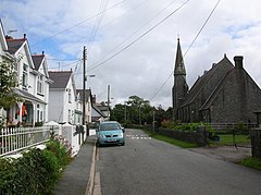
Llanwnda is a village, community and electoral ward in Gwynedd, Wales. The community has a population of 1,994 as taken at the 2011 Census.[1] It is situated about 3 miles to the south of Caernarfon, and 5 miles south-west of Llanrug. According to the 2011 Census, 81.6% of the population were Welsh speakers. The image on the right is of Glanrhyd, Llanwnda, not the village of Llanwnda less than a mile to the south. The community includes the slate mining villages of Rhosgadfan and Rhostryfan.
References[]
- ^ "Community/Ward population 2011". Retrieved 17 May 2015.
- The geographic coordinates are from the Ordnance Survey.
External links[]
| Wikimedia Commons has media related to Llanwnda, Gwynedd. |

| show Authority control |
|---|
This Gwynedd location article is a stub. You can help Wikipedia by . |
Categories:
- Llanwnda, Gwynedd
- Villages in Gwynedd
- Communities in Gwynedd
- Gwynedd geography stubs