Local government in The Bahamas
 |
|---|
|
Local government in the Bahamas exists in two forms, namely second-schedule and third-schedule district councils. There are a total of 32 local government districts: 13 second-schedule districts, which are further sub-divided into town areas, and 19 third-schedule districts, which are all unitary authorities. The second and third schedules together make up the first schedule.[1] Local government policy is formulated and administered by the Department of Lands and Local Government through the Office of the Prime Minister. The day-to-day policy handling of the portfolio falls to the Minister of Local Government who also is empowered to create new local government areas from time to time based on demographics. The administrative and financial management is overseen by the ministry's permanent secretary.[2]
History[]
Local government previously existed in the Bahamas in the form of appointed "Board of Works". Here towns and villages held their influence over these Board of Works, but almost all final decisions were made by the central government through that islands' Commissioner. The modern system of local government that is in use today was implemented on 8 March 1996. The Out Islands of the country could now enjoy a somewhat greater degree of autonomy, but New Providence Island, in which the capital city Nassau is located, was to be directly governed by the central government. The act that implemented local government had described all districts as either being Second-Schedule or Third-Schedule districts. [3]

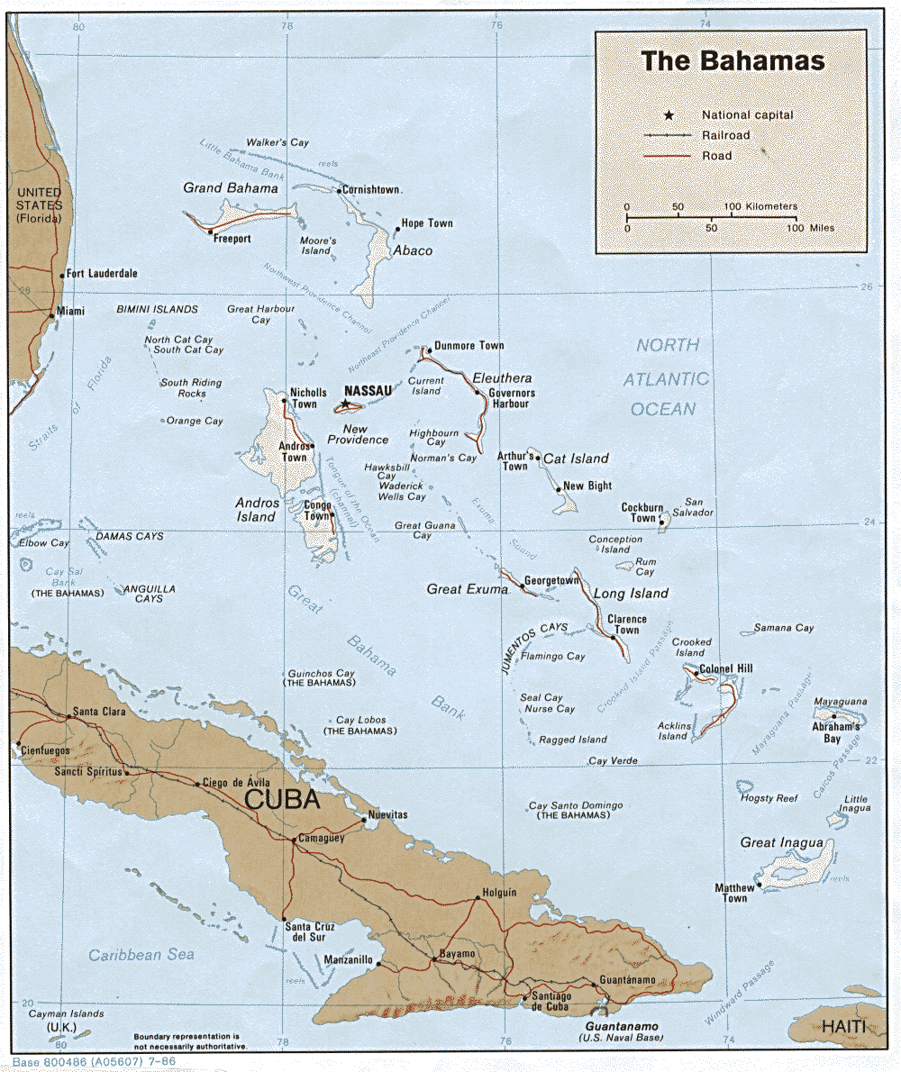
Districts of The Bahamas[]
The Districts of the Bahamas provide a system of Local Government everywhere in The Bahamas except New Providence (where Nassau the capital is located, whose affairs are handled directly by the central government). The current system dates from 1996 when 23 districts were "created" by The Bahamas Local Government Act of 1996– a further 9 have been added since 1999.[4]
Local Government in The Bahamas has seen great success since its introduction, but there has been concern over the case of New Providence and whether or not it should have local government.
Types of Councils[]
Every district in the Bahamas has a districts council.[5] A district council is a corporate body with perpetual succession; capable of entering into contracts, of suing and being sued, of acquiring, holdings, leasing and disposing of property of any description, and of doing all such things and entering into such transactions that are within the scope of the Local Government Act.[6] District Councillors are elected by the population of that district in accordance with Local Government Act.[7] As stated in The Bahamas Local Government Act 1996, Districts councillors shall within two weeks of their election, elect from among themselves a Chief Councillor.[8] The Chief Councillor shall be the representative of a Districts Council for all affairs. He or she is to preside over all meetings and also themselves co-ordinate these meetings.[9]
All districts councils are classed as first-schedule councils. The first-schedule is further sub-divided into two types of councils: two tier second-schedule district councils that have town committees within their jurisdiction, and unitary third-tier district councils.[10] Second-schedule districts have the following statutory boards and committees:
- Road Traffic Licensing Authority
- Port and Harbour Authority
- Hotel Licensing Board
- Liquor and Shop Licensing
- Town Planning Committee
Town committees are sub-structures of the second-schedule district councils, but are also corporate bodies themselves. They share responsibility with second-schedule district councils for a number of the schedule local government functions. They also have statutory responsibility for local regulation and licensing within their jurisdiction.[11] Third-schedule districts councils are unique within the Bahamas because they combine the responsibilities of the second-schedule districts and of the town committees. Both second- and third-schedule district councils carry out a building control function...[12]
| Island | 2nd tier | 3rd tier | Town | Population | |
|---|---|---|---|---|---|
| New Providence | 0 | 0 | 246,329 | ||
| Abaco islands | 3 | 4 | 17,242 | ||
| Acklins | 0 | 1 | 565 | ||
| Andros Island | 3 | 1 | 7,490 | ||
| Berry Islands | 0 | 1 | 807 | ||
| Bimini | 0 | 1 | 1,988 | ||
| Cat Island | 1 | 0 | 1,522 | ||
| Crooked Island | 0 | 1 | 330 | ||
| Grand Bahama | 2 | 1 | 51,368 | ||
| Harbour Island | 0 | 1 | 1,762 | ||
| Eleuthera | 2 | 1 | 8,202 | ||
| Exuma and Cays | 1 | 1 | 6,928 | ||
| Inagua | 0 | 1 | 913 | ||
| Long Island | 1 | 0 | 3,094 | ||
| Mayaguana | 0 | 1 | 277 | ||
| Ragged Island | 0 | 1 | 72 | ||
| Rum Cay | 0 | 1 | 99 | ||
| San Salvador | 0 | 1 | 930 | ||
| Spanish Wells | 0 | 1 | 1,551 | ||
| TOTAL | 13 | 19 | 351,461 | 13,940 | |
| Largest Council | 31,478 | 6,014 | |||
| Smallest Council | 72 | 1,548 |
Elections[]
Local government elections take place once every three years in the Bahamas[13] with the most recent elections taking place in June 2017.[14] The 2020 elections were postponed due to COVID-19 until Emergency Power Orders are lifted.[15] The voting system used in local government elections is the first-past-the-post system. Both councillors of third-schedule district councils and members of town committees are directly elected, while members of second-schedule councils are indirectly elected from town committees. Third schedule district councils have between five and nine members, whereas the size of councils in both second-schedule councils and town committees varies according to population size. By elections are held whenever the need arises. A councillor is deemed to have resigned if they are absent for three consecutive meetings.[citation needed]
For both types of district councils the Chief Councillors and their deputies are indirectly elected from amongst the elected officials. They serve for the lifetime of the council and the Minister of Local Government determines their stipend. Second-schedule district councils' statutory boards also elect chairpersons and their deputies from amongst their members.[16]
Major Islands[]

| Crest | Island's name | Capital (or largest settlement) | Population | Area (km2) |
|---|---|---|---|---|
| Acklins | [19] | 560 | 492 | |
| Abaco | Marsh Harbour[20] | 16,692 | 1,681 | |
| Andros | Andros Town | 7,386 | 5,957 | |
| Berry Islands | Nicholls Town | 798 | 31 | |
| Bimini | Alice Town | 2,008 | 23 | |
| [[]] | Exuma and Cays | George Town | 6,928 | 250 |
| Cat Island | Arthur's Town[21] | 1,503 | 389 | |
| Crooked Island | Colonel Hill[22] | 323 | 241 | |
| Eleuthera | Governor's Harbour[23] | 9,363 | 518 | |
| Grand Bahama | Freeport City[24] | 51,756 | 1,373 | |
| Inagua | Matthew Town[25] | 911 | 1,679 | |
| Long Island | Clarence Town[26] | 3,024 | 596 | |
| Mayaguana | Abraham's Bay | 271 | 285 | |
| New Providence | Nassau | 248,948 | 207 | |
| Ragged | Duncan Town[27] | 70 | 36 | |
| Rum Cay | Port Nelson | 99 | 78 | |
| San Salvador | Cockburn Town[28] | 930 | 163 | |
| Nassau | 353,658[29] | 13,943 |
See also[]
- Chief Councillor
- Hope Town District Council
- Constituencies of the Bahamas
- ISO 3166-2:BS
- List of Caribbean First-level Subdivisions by Total Area
- List of newspapers in the Bahamas
- Commonwealth Local Government Forum-Americas
References[]
- ^ "The Local Government System in the Bahamas". Commonwealth Local Government Forum.
- ^ "The Local Government System in the Bahamas:Ministerial oversight:". Commonwealth Local Government Forum.
- ^ "West Indies". The Hope Town District Council. Archived from the original on 26 October 2011. Retrieved 27 November 2010.
- ^ "Laws and Acts". Retrieved 20 December 2010.
- ^ Bahamas Local Government Act 1996, Part IV, Section 10:1 Retrieved-November-27
- ^ Bahamas Local Government Act 1996, Part IV, 10:2 Retrieved-November-27
- ^ Bahamas Local Government Act 1996, Part IV, 10:4 Retrieved-November-27
- ^ Bahamas Local Government Act 1996, Part IV, 11 Retrieved-November-27
- ^ Bahamas Local Government Act 1996, Part IV, 11:2 Retrieved-November-27
- ^ "The Local Government System in the Bahamas:Council Types". Commonwealth Local Government Forum.
- ^ "The Local Government System in the Bahamas:Council Types:Second-schedule District Councils&Town Committees". Commonwealth Local Government Forum.
- ^ "The Local Government System in the Bahamas:Council Types:Third-Schedule Districts". Commonwealth Local Government Forum.
- ^ Gibbs, Gena (25 June 2011). "Local Government holds national elections in Family Islands". Bahamas Information Services.
- ^ Vedrine. "Minister Campbell Observes Local Government Elections". www.bahamaslocal.com. Retrieved 19 August 2021.
- ^ "Ministry of Transport and Local Government announces the postponement of Local Government Elections". www.bahamaslocal.com. Retrieved 19 August 2021.
- ^ "The Local Government System in the Bahamas:Elections". Commonwealth Local Government Forum.
- ^ "Reference map for the Islands of the Bahamas". Retrieved 20 December 2010.
- ^ "The Commonwealth of the Bahamas". Retrieved 20 December 2010.
- ^ "Acklins / Crooked Island Activities and Attractions". Archived from the original on 24 March 2006. Retrieved 20 December 2010.
- ^ "DeBora's Dreamscape". Retrieved 20 December 2010.
- ^ "Majestic Holidays". Archived from the original on 22 May 2010. Retrieved 20 December 2010.CS1 maint: unfit URL (link)
- ^ "Acklins Island and Crooked Island, Bahamas". Retrieved 20 December 2010.
- ^ "Med Point". Retrieved 20 December 2010.
- ^ "Grand Bahama - an impartial guide to the Island". Archived from the original on 29 November 2012. Retrieved 20 December 2010.
- ^ "The Inaguas". Retrieved 20 December 2010.
- ^ "Bahamas Gateway Yellow Pages -- Hotels". Retrieved 20 December 2010.
- ^ "DeBora's Dreamscape". Retrieved 20 December 2010.
- ^ "San Salvador Bahamas: Christopher Columbus First Landfall". Archived from the original on 12 September 2012. Retrieved 20 December 2010.
- ^ "Comparison between the 2000 and 2010 Population Censuses and Percentage Change" (PDF). Retrieved 20 December 2010.
External links[]
| show Administrative divisions of the Americas |
|---|

- Districts of the Bahamas
- Subdivisions of the Bahamas
- Lists of administrative divisions
- Administrative divisions in North America
- Bahamas-related lists