Transport in the Bahamas
This article needs additional citations for verification. (December 2009) |
This article talks about transportation in the Bahamas, a North American archipelagic state in the Atlantic Ocean.
Highways[]
Approximately 2,718 kilometres (1,689 mi) of road in the Bahamas is classified as highway. Of these, approximately 1,560 kilometres (970 mi) are paved. Drivers drive on the left.
Ports and harbours[]
Marinas and harbours are plentiful on The Bahamas islands, making aquatic travel an easy way to navigate between the islands group. Boat travel can be the only way to reach some of the smaller islands. Travelers entering the island will need to clear customs first, but boatsmen can enter any of the following ports of entry and harbours in The Bahamas:
- Abaco Islands: Green Turtle Cay, Marsh Harbour, Spanish Cay, Treasure Cay, or Walker's Cay
- Berry Islands: Chub Cay and Great Harbour Cay
- Bimini: Alice Town
- Cat Cays: Hawksnest Marina
- Eleuthera: Governor's Harbour, Harbour Island, Rock Sound, or Spanish Wells
- Exuma: George Town
- Grand Bahama Island: Freeport Harbour, Lucayan Marina Village and Port Lucaya, or Old Bahama Bay at West End
- Inagua: Matthew Town
- Long Island: Stella Maris Airport
- Mayaguana: Abraham's Bay
- Nassau/New Providence Island: Any marina
- San Salvador: Cockburn Town
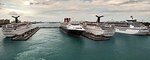
Facilities catering to large passenger cruise ships are located on Grand Bahama Island and New Providence. The Lucayan Harbour Cruise Facility in Freeport[1] and Nassau harbour's Prince George Wharf are built specifically to handle multiple modern cruise ships at one time.[citation needed] Additionally, several major cruise line corporations have each purchased an uninhabited island which they now operate as private island destinations available exclusively to their respective ships. These include Great Stirrup Cay, owned by Norwegian Cruise Line, Little Stirrup Cay otherwise known as Royal Caribbean International's "Coco Cay", Carnival Corporation's Little San Salvador Island or "Half Moon Cay", and Castaway Cay, of Disney Cruise Line. Of these, only Castaway Cay offers ships an actual pier for docking. The others use tender boats to service ships anchored off shore.
Merchant marine[]
Total: 1,440 (2017 - CIA World Factbook) By type: bulk carrier 335, container ship 53, general cargo 98, oil tanker 284, other 670 (2017)
The Bahamas are one of the world's top five flag of convenience shipping registries.
Airports[]
The main airports on the islands are Lynden Pindling International Airport on New Providence, Grand Bahama International Airport on Grand Bahama Island, and Marsh Harbour International Airport on Abaco Island.[citation needed] Out of 62 airports in all, 23 have paved runways, of which there are two that are over 3,047 meters long.
Airports with paved runways:
- total: 23
- over 3,047 m: 2
- 2,438 to 3,047 m: 4
- 1,524 to 2,437 m: 11
- 914 to 1,523 m: 6 (2008)
Airports with unpaved runways:
- total: 39
- 1,524 to 2,437 m: 5
- 914 to 1,523 m: 12
- under 914 m: 22 (2008)
Airlines[]
Bahamasair is the national flag carrier airline of the Bahamas.[2]
Heliports[]
A heliport is located on Paradise Island,[3] as well as other smaller islands, such as the various cruise line private islands.
Railways[]
There are no railways in the Bahamas.
References[]
- ^ "Grand Bahama - Vision Meets Opportunity", page 10. Grand Bahama Port Authority. Retrieved March 17, 2010.
- ^ "About Bahamasair". Archived 2009-03-30 at the Wayback Machine Bahamasair. Archived 2010-03-24 at the Wayback Machine Retrieved March 17, 2010.
- ^ "Spotlight on Nassau, Bahamas! - Flare". www.flare.com. Retrieved 2019-01-30.
External links[]
| Wikimedia Commons has media related to Transport in the Bahamas. |
| show Transport in the Americas |
|---|

- Transport in the Bahamas