Londonderry Township, Guernsey County, Ohio
Londonderry Township, Guernsey County, Ohio | |
|---|---|
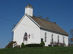 Londonderry Methodist Church | |
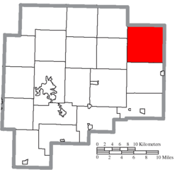 Location of Londonderry Township in Guernsey County | |
| Coordinates: 40°7′57″N 81°17′8″W / 40.13250°N 81.28556°WCoordinates: 40°7′57″N 81°17′8″W / 40.13250°N 81.28556°W | |
| Country | United States |
| State | Ohio |
| County | Guernsey |
| Area | |
| • Total | 36.4 sq mi (94.2 km2) |
| • Land | 36.3 sq mi (94.1 km2) |
| • Water | 0.04 sq mi (0.1 km2) |
| Elevation | 876 ft (267 m) |
| Population (2010) | |
| • Total | 727 |
| • Density | 20/sq mi (7.7/km2) |
| Time zone | UTC-5 (Eastern (EST)) |
| • Summer (DST) | UTC-4 (EDT) |
| FIPS code | 39-44716[2] |
| GNIS feature ID | 1086184[1] |

Londonderry Township is one of the nineteen townships of Guernsey County, Ohio, United States. As of the 2010 census the population was 727.[3]
Geography[]
Located in the northeastern corner of the county, it borders the following townships:
- Freeport Township, Harrison County - north
- Flushing Township, Belmont County - northeast
- Kirkwood Township, Belmont County - southeast
- Oxford Township - south
- Madison Township - southwest
- Washington Township - northwest
No municipalities are located in Londonderry Township.
Name and history[]
It is the only Londonderry Township statewide.[4]
Government[]
The township is governed by a three-member board of trustees, who are elected in November of odd-numbered years to a four-year term beginning on the following January 1. Two are elected in the year after the presidential election and one is elected in the year before it. There is also an elected township fiscal officer,[5] who serves a four-year term beginning on April 1 of the year after the election, which is held in November of the year before the presidential election. Vacancies in the fiscal officership or on the board of trustees are filled by the remaining trustees.
References[]
- ^ a b "US Board on Geographic Names". United States Geological Survey. 2007-10-25. Retrieved 2008-01-31.
- ^ "U.S. Census website". United States Census Bureau. Retrieved 2008-01-31.
- ^ "Geographic Identifiers: 2010 Demographic Profile Data (G001): Londonderry township, Guernsey County, Ohio". American Factfinder. U.S. Census Bureau. Retrieved January 19, 2017.[dead link]
- ^ "Detailed map of Ohio" (PDF). United States Census Bureau. 2000. Retrieved 2007-02-16.
- ^ §503.24, §505.01, and §507.01 of the Ohio Revised Code. Accessed 4/30/2009.
External links[]
Municipalities and communities of Guernsey County, Ohio, United States | ||
|---|---|---|
| City |  | |
| Villages | ||
| Townships | ||
| CDPs | ||
| Unincorporated communities | ||
| Footnotes | ‡This populated place also has portions in an adjacent county or counties | |
| ||
- Townships in Guernsey County, Ohio
- Townships in Ohio