Loučná pod Klínovcem
Loučná pod Klínovcem | |
|---|---|
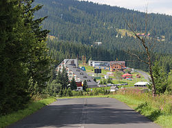 Road to Loučná pod Klínovcem | |
 Flag  Coat of arms | |
 Loučná pod Klínovcem Location in the Czech Republic | |
| Coordinates: 50°24′46″N 12°59′23″E / 50.41278°N 12.98972°ECoordinates: 50°24′46″N 12°59′23″E / 50.41278°N 12.98972°E | |
| Country | |
| Region | Ústí nad Labem |
| District | Chomutov |
| First mentioned | 1431 |
| Government | |
| • Mayor | Jana Müllerová (Ind.) |
| Area | |
| • Total | 20.89 km2 (8.07 sq mi) |
| Elevation | 865 m (2,838 ft) |
| Population (2021-01-01)[1] | |
| • Total | 118 |
| • Density | 5.6/km2 (15/sq mi) |
| Time zone | UTC+1 (CET) |
| • Summer (DST) | UTC+2 (CEST) |
| Postal code | 431 91 |
| Website | www |

Loučná pod Klínovcem (until 1947 Český Wiesenthal; German: Böhmisch Wiesenthal) is a small town in the Czech Republic. It has about 100 inhabitants and it is the second least populated town in the country.
The town lies on the border with Germany. The German part of the divided town is called Oberwiesenthal.
Administrative parts[]
The town is made up of two parts, Háj and Loučná.
Notable people[]
- Hans Erich Slany (1926–2013), German industrial designer
References[]
External links[]
| Wikimedia Commons has media related to Loučná pod Klínovcem. |
| Authority control: National libraries |
|---|
This Ústí nad Labem Region location article is a stub. You can help Wikipedia by . |
Categories:
- Cities and towns in the Czech Republic
- Populated places in Chomutov District
- Towns in the Ore Mountains
- Divided cities
- Czech Republic–Germany border crossings
- Ústí nad Labem Region geography stubs