Lovendegem
Lovendegem | |
|---|---|
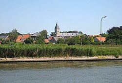 Lovendegem, seen across the Ghent-Bruges Canal | |
 Flag  Coat of arms | |
 Lovendegem Location in Belgium
show Location of Lovendegem in East Flanders | |
| Coordinates: 51°06′N 03°36′E / 51.100°N 3.600°ECoordinates: 51°06′N 03°36′E / 51.100°N 3.600°E | |
| Country | Belgium |
| Community | Flemish Community |
| Region | Flemish Region |
| Province | East Flanders |
| Arrondissement | Ghent |
| Government | |
| • Mayor | Tony Vermeire (CD&V) |
| • Governing party/ies | CD&V |
| Area | |
| • Total | 19.48 km2 (7.52 sq mi) |
| Population (2018-01-01)[1] | |
| • Total | 9,574 |
| • Density | 490/km2 (1,300/sq mi) |
| Postal codes | 9920, 9921 |
| Area codes | 09 |
| Website | www.lievegem.be |


Lovendegem (Dutch pronunciation: [ˌloːˈvɛndəɣɛm]) is a former municipality located in Flanders, one of the three regions of Belgium, and in the province of East Flanders. The municipality comprised the towns of Lovendegem proper and Vinderhoute.[2] On January 1, 2006, Lovendegem had a total population of 9,358. The total area is 19.48 km² which gives a population density of 480 inhabitants per square kilometer.
The name of the town was first recorded as Lovendenghiem in 1150,[3] but there are traces of human settlements back to the Iron Age.
The crosses the municipality, with the town of Lovendegem to the north of the canal, and Vinderhoute to the south.
Effective 1 January 2019, Waarschoot, Lovendegem and Zomergem were merged into the new municipality of Lievegem.
Gallery[]

Lovendegem, townhall

Lovendegem, church: Sint Martinuskerk


Famous inhabitants[]
- Maurice De Waele, cyclist, winner of the Tour de France
References[]
- ^ "Wettelijke Bevolking per gemeente op 1 januari 2018". Statbel. Retrieved 9 March 2019.
- ^ "Vinderhoute".
- ^ "Lovendegem".
External links[]
 Media related to Lovendegem at Wikimedia Commons
- Official website (in Dutch)
| show Places adjacent to Lovendegem |
|---|
| show Authority control |
|---|
This East Flanders location article is a stub. You can help Wikipedia by . |
- Lovendegem
- Lievegem
- Former municipalities of East Flanders
- Populated places disestablished in 2019
- East Flanders geography stubs