Lugagnano Val d'Arda
Lugagnano Val d'Arda | |
|---|---|
| Comune di Lugagnano Val d'Arda | |
 | |
show Location of Lugagnano Val d'Arda | |
 Lugagnano Val d'Arda Location of Lugagnano Val d'Arda in Italy | |
| Coordinates: 44°49′N 9°49′E / 44.817°N 9.817°E | |
| Country | Italy |
| Region | Emilia-Romagna |
| Province | Piacenza (PC) |
| Frazioni | Antognano, Chiavenna Rocchetta, Diolo, Montezago, Prato Ottesola, Rustigazzo, Tabiano, Velleia, Vicanino |
| Government | |
| • Mayor | Jonathan Papamarenghi |
| Area | |
| • Total | 54.4 km2 (21.0 sq mi) |
| Elevation | 229 m (751 ft) |
| Population | |
| • Total | 3,997 |
| • Density | 73/km2 (190/sq mi) |
| Demonym(s) | Lugagnanesi |
| Time zone | UTC+1 (CET) |
| • Summer (DST) | UTC+2 (CEST) |
| Postal code | 29018 |
| Dialing code | 0523 |
| Website | Official website |


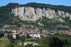
Lugagnano Val d'Arda (Piacentino: Lügagnan) is a comune (municipality) in the Province of Piacenza in the Italian region Emilia-Romagna.
Geography[]
It's located about 130 kilometres (81 mi) northwest of Bologna and about 30 kilometres (19 mi) southeast of Piacenza, on the Arda stream.
Lugagnano Val d'Arda borders the following municipalities: Carpaneto Piacentino, Castell'Arquato, Gropparello, Morfasso, Vernasca.
References[]
- ^ "Superficie di Comuni Province e Regioni italiane al 9 ottobre 2011". Istat. Retrieved 16 March 2019.
- ^ "Popolazione Residente al 1° Gennaio 2018". Istat. Retrieved 16 March 2019.
- ^ All demographics and other statistics: Italian statistical institute Istat.
External links[]

| show Authority control |
|---|
Categories:
- Cities and towns in Emilia-Romagna
- Municipalities of the Province of Piacenza
- Emilia-Romagna geography stubs