Travo
Travo | |
|---|---|
| Comune di Travo | |
 | |
 Travo within the Province of Piacenza | |
show Location of Travo | |
 Travo Location of Travo in Italy | |
| Coordinates: 44°52′N 9°33′E / 44.867°N 9.550°ECoordinates: 44°52′N 9°33′E / 44.867°N 9.550°E | |
| Country | Italy |
| Region | Emilia-Romagna |
| Province | Piacenza (PC) |
| Frazioni | Bobbiano, Caverzago, Cernusca, Donceto, Due Bandiere, Fellino, Fiorano, Marchesi, Pigazzano, Pillori, Quadrelli, Scrivellano, Statto, Viserano |
| Government | |
| • Mayor | Ludovico Albasi |
| Area | |
| • Total | 80.4 km2 (31.0 sq mi) |
| Elevation | 171 m (561 ft) |
| Population (31 December 2017)[3] | |
| • Total | 2,121 |
| • Density | 26/km2 (68/sq mi) |
| Demonym(s) | Travesi |
| Time zone | UTC+1 (CET) |
| • Summer (DST) | UTC+2 (CEST) |
| Postal code | 29020 |
| Dialing code | 0523 |
| Website | Official website |


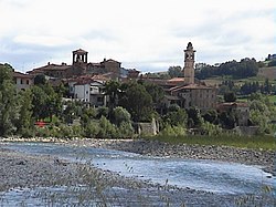
Travo (Piacentino: Träv [træːv]) is a comune (municipality) in the Province of Piacenza in the Italian region Emilia-Romagna, located about 150 kilometres (93 mi) northwest of Bologna and about 25 kilometres (16 mi) southwest of Piacenza. It is on the left bank of the Trebbia river.
Geography[]
Travo borders the following municipalities: Alta Val Tidone, Bettola, Bobbio, Coli, Gazzola, Piozzano, Rivergaro and Vigolzone.
References[]
- ^ "Superficie di Comuni Province e Regioni italiane al 9 ottobre 2011". Istat. Retrieved 16 March 2019.
- ^ "Popolazione Residente al 1° Gennaio 2018". Istat. Retrieved 16 March 2019.
- ^ All demographics and other statistics: Italian statistical institute Istat.
External links[]
| Wikimedia Commons has media related to Travo. |

Categories:
- Cities and towns in Emilia-Romagna
- Municipalities of the Province of Piacenza
- Emilia-Romagna geography stubs