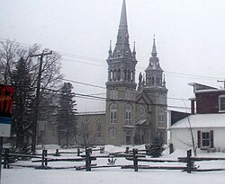
Lyster, Quebec
Lyster | |
|---|---|
Municipality | |
 | |
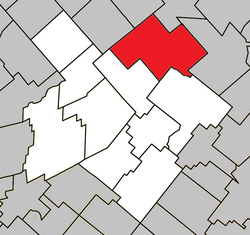 Location within L'Érable RCM | |
 Lyster Location in southern Quebec | |
| Coordinates: 46°22′N 71°37′W / 46.367°N 71.617°WCoordinates: 46°22′N 71°37′W / 46.367°N 71.617°W[1] | |
| Country | Canada |
| Province | Quebec |
| Region | Centre-du-Québec |
| RCM | L'Érable |
| Constituted | September 18, 1976 |
| Government | |
| • Mayor | Sylvain Labrecque |
| • Federal riding | Mégantic—L'Érable |
| • Prov. riding | Lotbinière |
| Area | |
| • Total | 167.80 km2 (64.79 sq mi) |
| • Land | 168.25 km2 (64.96 sq mi) |
| There is an apparent contradiction between two authoritative sources | |
| Population (2011)[3] | |
| • Total | 1,628 |
| • Density | 9.7/km2 (25/sq mi) |
| • Pop 2006-2011 | |
| • Dwellings | 753 |
| Time zone | UTC−5 (EST) |
| • Summer (DST) | UTC−4 (EDT) |
| Postal code(s) | G0S 1V0 |
| Area code(s) | 819 |
| Highways | |
| Website | www |

Lyster is a municipality in the Centre-du-Québec region of the province of Quebec in Canada. It was created with the fusion of the parish and the village of Lyster in 1976.
See also[]
- Lyster
References[]
- ^ Reference number 72467 of the Commission de toponymie du Québec (in French)
- ^ Jump up to: a b Geographic code 32065 in the official Répertoire des municipalités (in French)
- ^ Jump up to: a b "(Code 2432065) Census Profile". 2011 census. Statistics Canada. 2012.
External links[]
![]() Media related to Lyster at Wikimedia Commons
Media related to Lyster at Wikimedia Commons
| show Places adjacent to Lyster, Quebec |
|---|
| show |
|---|
| show Authority control |
|---|
This Quebec location article is a stub. You can help Wikipedia by . |
Categories:
- Municipalities in Quebec
- Incorporated places in Centre-du-Québec
- Quebec geography stubs