Wôlinak
(Redirected from )
Wôlinak | |
|---|---|
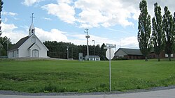 Wôlinak village | |
 Location within Bécancour RCM. | |
 Wôlinak Location in southern Quebec. | |
| Coordinates: 46°19′N 72°25′W / 46.317°N 72.417°WCoordinates: 46°19′N 72°25′W / 46.317°N 72.417°W[1] | |
| Country | |
| Province | |
| Region | Centre-du-Québec |
| RCM | None |
| Constituted | unspecified |
| Government | |
| • Type | Band council |
| • Federal riding | Bas-Richelieu— Nicolet—Bécancour |
| • Prov. riding | Nicolet-Bécancour |
| Area | |
| • Total | 0.80 km2 (0.31 sq mi) |
| • Land | 0.75 km2 (0.29 sq mi) |
| Population | |
| • Total | 180 |
| • Density | 239.9/km2 (621/sq mi) |
| • Pop 2006-2011 | |
| • Dwellings | 89 |
| Time zone | UTC−5 (EST) |
| • Summer (DST) | UTC−4 (EDT) |
| Area code(s) | 450 |
| Highways | No major routes |

Wôlinak is an Abenaki First Nations reserve in the Centre-du-Québec region, Quebec, Canada. An enclave within the city of Bécancour, it was one of the Seven Nations of Canada.
History[]
Around 1600, a few Abenaki families and Sokokis families established themselves on the Puante river (name given after a battle with the English colonists against the French colonists) which later, was given the name of Bécancour from the name of M. de Bécancour, Baron de Portneuf, who was also established there.
From 600 inhabitants in the beginning, their numbers diminished after wars and epidemics.
See also[]
- Western Abenaki
- Seven Nations of Canada
References[]
- ^ Reference number 136958 of the Commission de toponymie du Québec (in French)
- ^ a b Geographic code 38802 in the official Répertoire des municipalités (in French)
- ^ a b "(Code 2438802) Census Profile". 2011 census. Statistics Canada. 2012.
External links[]
| Cities | |
|---|---|
| Municipalities | |
| Parishes | |
| |
This Quebec location article is a stub. You can help Wikipedia by . |
This First Nations-related article is a stub. You can help Wikipedia by . |
Categories:
- Indian reserves in Quebec
- Communities in Centre-du-Québec
- Abenaki communities
- Quebec geography stubs
- First Nations stubs