Machhapuchchhre Rural Municipality
Machhapuchchhre
माछापुछ्रे | |
|---|---|
 Machhapuchchhre Location in Nepal | |
| Coordinates: 28°28′N 84°00′E / 28.47°N 84.00°ECoordinates: 28°28′N 84°00′E / 28.47°N 84.00°E | |
| Country | |
| Province | Gandaki |
| District | Kaski District |
| Area | |
| • Total | 545 km2 (210 sq mi) |
| Population | |
| • Total | 21,920 |
| • Density | 40/km2 (100/sq mi) |
| Time zone | UTC+5:45 (Nepal Time) |
| Website | machhapuchhremun.gov.np |


Machhapuchchhre is a Gaunpalika and former village development committee in Kaski District in the Gandaki Province of northern-central Nepal. At the time of the 1991 Nepal census it had a population of 1,881 persons living in 378 individual households.[1][2]

Machhapuchchhre Mountain in Nepal
References[]
- ^ "Nepal Census 2001". Nepal's Village Development Committees. Digital Himalaya. Archived from the original on 12 October 2008. Retrieved 30 September 2008.
- ^ "माछापुच्छ्रे गाउँपालिका, गाउँ कार्यपालिकाको कार्यालय | गण्डकी प्रदेश, नेपाल". machhapuchhremun.gov.np. Retrieved 2020-07-09.
External links[]
Headquarters: Pokhara | ||
| Metropolitan cities | 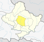 | |
| Rural municipalities | ||
| Former VDCs |
| |
| Villages | ||
This article about a location in the Kaski District of Nepal is a stub. You can help Wikipedia by . |
Categories:
- Populated places in Kaski District
- Rural municipalities of Nepal established in 2017
- Rural municipalities in Kaski District
- Kaski District geography stubs