Lumle
Lumle
लुम्ले | |
|---|---|
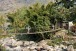 Bridge over Dhoti Khola | |
 Lumle Location in Nepal | |
| Coordinates: 28°21′N 83°50′E / 28.35°N 83.83°ECoordinates: 28°21′N 83°50′E / 28.35°N 83.83°E | |
| Country | |
| Zone | Gandaki Zone |
| Kaski District | |
| Population (1991) | |
| • Total | 4,685 |
| Time zone | UTC+5:45 (NST) |
| Area code(s) | 061 |


Shiva sanctuary in Nayapul

Lumle Village Landscape
Lumle is a town and village development committee in Kaski District in the Gandaki Zone of northern-central Nepal At the time of the 1991 Nepal census it had a population of 4,685 persons living in 955 individual households.[1]
Localities[]
Educational Institutions in Lumle[]
- Balmandir Community School ( Community)
- Future Star English Boarding School (Private)
- Shree Siddha lower secondary school (Government)
- Shree Sangam Secondary School (Government)
Climate[]
| Month | Jan | Feb | Mar | Apr | May | Jun | Jul | Aug | Sep | Oct | Nov | Dec | Year |
|---|---|---|---|---|---|---|---|---|---|---|---|---|---|
| Average high °C (°F) | 13 (55) |
14 (57) |
19 (66) |
22 (72) |
22 (72) |
23 (73) |
22 (72) |
23 (73) |
21 (70) |
20 (68) |
16 (61) |
13 (55) |
19 (66) |
| Average low °C (°F) | 5 (41) |
6 (43) |
10 (50) |
13 (55) |
14 (57) |
17 (63) |
17 (63) |
17 (63) |
16 (61) |
14 (57) |
9 (48) |
6 (43) |
12 (54) |
| Average rainfall mm (inches) | 28 (1.1) |
45 (1.8) |
52 (2.0) |
194 (7.6) |
318 (12.5) |
902 (35.5) |
1,522 (59.9) |
1,339 (52.7) |
932 (36.7) |
294 (11.6) |
23 (0.9) |
2 (0.1) |
5,651 (222.4) |
| Source: [2] | |||||||||||||
References[]
- ^ "Nepal Census 2001". Nepal's Village Development Committees. Digital Himalaya. Archived from the original on 12 October 2008. Retrieved 30 September 2008.
- ^ "Climatological Data of Nepal". www.thamel.com.
External links[]
Headquarters: Pokhara | ||
| Metropolitan cities | 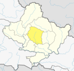 | |
| Rural municipalities | ||
| Former VDCs |
| |
| Villages | ||
This article about a location in the Kaski District of Nepal is a stub. You can help Wikipedia by . |
Categories:
- Populated places in Kaski District
- Kaski District geography stubs