Mahajanga
Mahajanga
Majunga | |
|---|---|
District and city | |
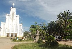 Mahajanga Cathedral | |
 Coat of arms | |
 Mahajanga Location in Madagascar | |
| Coordinates: 15°43′S 46°19′E / 15.717°S 46.317°ECoordinates: 15°43′S 46°19′E / 15.717°S 46.317°E | |
| Country | |
| Region | Boeny |
| District | Mahajanga District |
| Mahajanga | |
| Area | |
| • Total | 51.05 km2 (19.71 sq mi) |
| Population (2018 census) | |
| • Total | 246,022 |
| • Density | 4,800/km2 (12,000/sq mi) |
| Climate | Aw |

Mahajanga [maːˈdzaŋɡə̥] (French: Majunga) is a city and an administrative district on the northwest coast of Madagascar.
Mahajanga is a tourist destination for Malagasy tourists and international travelers, with beaches, a coconut-lined boardwalk ("Le Bord", short for "Bord de la mer" or sea-side), and eight months of hot, virtually rain-free weather.
City[]


The city of Mahajanga (Mahajanga I) is the capital of the Boeny Region. The district (identical to the city) had a population of 220,629 in 2013.[1]
Mahajanga is a seaport, the second most important one in Madagascar after Toamasina. The marine terminal accommodates containerships and small (150 gross ton) general cargo freighters. Because of limited water depth at the wharf, only small ships can call at the terminal. Deeper-draft ships anchor off the terminal and transfer cargoes to and from barges, which move it to and from the terminal.
Severe storms during December 2006 damaged the bulkhead, allowing water to flow in and wash backfill out from under the terminal's paving blocks. The resulting collapse of pavement blocks has made operations at the terminal less efficient and reduced the storage space available. The largest and most valuable containerized export is frozen shrimp.
There is an international airport with regional flights to the Comoros and Mayotte.
Mahajanga is on the Betsiboka River, which then leads to Bombetoka Bay.
The city has a sizable Muslim population. In 1977, it was the scene of ethnic unrest, forcing the evacuation of the Comorian minority living there. Mahajanga is also the seat of a Roman Catholic Diocese (Cathedral of the Holy Heart of Mary).
Since 2016, World Christian Broadcasting has operated shortwave radio station MWV (Madagascar World Voice), a sister station of KNLS in Alaska, USA.[2][3][4]
Baobab[]
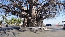
The African baobab tree near the coast is the largest specimen in Madagascar, having a circumference of 21 metres (69 ft), and is the symbol of the city. Its age is unknown, but it is usually said to be 700–800 years old. It was once used as a site of important meetings, and, in the 19th century, as a site for executions. It is said that to honor the Malagasy ancestors, anyone who visits it must walk around it seven times.[5]
History[]
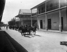
According to Jane Hooper, "Since the tenth century, ports in the north of Madagascar, home to an Islamized population, had attracted merchants and migrants from East Africa, the Middle East, and even the Far East. At least a dozen ports were identified in northern Madagascar by the late fifteenth century by the Arab geographer Ibn Mājid...By the early eighteenth century, Andriamandisoarivo, with the support of his eight-hundred-man army, founded a new Sakalava dynasty in the north which he named Volamena, meaning red money or gold. His descendants were known as the Zafibolamena, children of the Volamena. He died in the northern city of Bezavo around 1710, having cemented his name in traditions as the founder of a powerful new kingdom. His kingdom contained the port of Mazalagem Nova, or Massaliege, already a prosperous center for trade, as well as the new ports of Boina and Mahajanga (Majunga)...One English captain described the northwestern town of Mahajanga as a bustling, cosmopolitan port in 1764. He wrote that the town, built “after the Indian fashion,” contained many stone buildings and mosques. Inhabited by “native” Muslims and others from “Surate, Johana, Mosembeck, and the Commoro islands,” Mahajanga was clearly a prosperous and cosmopolitan port. Within the city, the Sakalava rulers allowed Muslims to practice their religion freely. In return, the Sakalava instituted a series of trading controls. The king appointed a “purser authorized to carry trade on in the king’s name, in conjunction with another purser that comes down from the king.” Sakalava kings and queens even allowed visiting European merchants to trade with local Muslim merchants as well as with Sakalava representatives and appeared to be increasingly tapped into these networks crossing the southwestern Indian Ocean region. A Sakalava queen married an East African (or Comorian) man around the middle of the eighteenth century, according to English and Dutch reports. Sakalava kings and queens also incorporated Islamic beliefs and rituals into their practice of divine kingship and some converted to Islam by the early nineteenth century."[6]
Indian community[]
In the 1780s, a community of roughly 200 Muslim traders from the Indian Subcontinent had formed at Mahajanga at the mouth of the Betsiboka River, according to French traveler Dumaine. Thus, the etymology of the word "Mahajanga" may be Indic.[citation needed] Confusion arose over their legal status; they often declared themselves to be Malagasy subjects to evade the laws against slave-holding or the building of stone houses, both forbidden to British subjects. Their dhows, which they used to transport goods to and from the African mainland, flew French flags. Initial arrivals were mainly Muslim Khojas, Ismailis and Daoudi Bohras, with some Hindus settling later.
The 1911 census found 4,480 Indians in the country, making them 21% of the total foreign population and the second-largest foreign population after the French. Following the nationalisation of private businesses in the 1970s, many were compelled to leave; those who remained were largely uneducated but stayed on and gradually built their businesses. By 2000, they were generally believed to control 50-60% of the country's economy, making them the target of demonstrators during periods of unrest.
In December 2006, a cyclone hit Mahajanga, causing significant damage to the port facilities and to some buildings on or near the coast.
Military history[]
The city has an airfield which the British used to station Shackleton aircraft to support the Beira Patrol from May 1966.[7]
Surrounding district[]
Mahajanga II is an administrative district surrounding but separate from the city (which is Mahajanga I). Its population was 77,524 in 2013.[8]
Region[]
Mahajanga is the capital city of the Boeny Region.
Sports[]
- Fosa Juniors FC is the local football club.
Climate[]
Mahajanga has a tropical savanna climate (Köppen Aw) with two distinct seasons: a humid, rainy wet season from November to mid-April, and a sunny, less humid and practically bone-dry dry season for the remaining six-and-a-half months. Cyclones can occur during the wet season, producing very heavy rain and extensive erosion.
| hideClimate data for Mahajanga | |||||||||||||
|---|---|---|---|---|---|---|---|---|---|---|---|---|---|
| Month | Jan | Feb | Mar | Apr | May | Jun | Jul | Aug | Sep | Oct | Nov | Dec | Year |
| Average high °C (°F) | 31.1 (88.0) |
30.8 (87.4) |
32.0 (89.6) |
32.5 (90.5) |
32.0 (89.6) |
31.0 (87.8) |
30.8 (87.4) |
31.4 (88.5) |
32.1 (89.8) |
32.5 (90.5) |
32.2 (90.0) |
31.3 (88.3) |
31.6 (88.9) |
| Daily mean °C (°F) | 27.1 (80.8) |
27.2 (81.0) |
27.5 (81.5) |
27.4 (81.3) |
26.1 (79.0) |
24.6 (76.3) |
24.2 (75.6) |
24.6 (76.3) |
25.4 (77.7) |
26.8 (80.2) |
27.7 (81.9) |
27.4 (81.3) |
26.3 (79.3) |
| Average low °C (°F) | 23.6 (74.5) |
23.8 (74.8) |
23.6 (74.5) |
22.9 (73.2) |
20.6 (69.1) |
18.6 (65.5) |
18.0 (64.4) |
18.4 (65.1) |
19.6 (67.3) |
22.0 (71.6) |
23.5 (74.3) |
23.7 (74.7) |
21.5 (70.7) |
| Average rainfall mm (inches) | 401.7 (15.81) |
385.9 (15.19) |
196.3 (7.73) |
69.7 (2.74) |
8.6 (0.34) |
0.7 (0.03) |
1.8 (0.07) |
2.9 (0.11) |
2.3 (0.09) |
9.9 (0.39) |
118.0 (4.65) |
278.2 (10.95) |
1,476 (58.1) |
| Average rainy days (≥ 1.0 mm) | 17 | 16 | 12 | 4 | 1 | 1 | 1 | 1 | 1 | 2 | 6 | 13 | 75 |
| Average relative humidity (%) | 82 | 83 | 81 | 73 | 67 | 64 | 62 | 60 | 63 | 66 | 72 | 80 | 71 |
| Mean monthly sunshine hours | 209.0 | 184.9 | 244.8 | 269.9 | 294.9 | 282.9 | 291.5 | 303.1 | 307.0 | 319.7 | 288.2 | 227.3 | 3,223.2 |
| Source 1: NOAA[9] | |||||||||||||
| Source 2: Weltwetter Spiegel Online (humidity)[10] | |||||||||||||
Education[]
The is located in Ambondrona campus. A regional centre for distance education (CRTE) of the Centre National de Télé-Enseignement de Madagascar (CNETMAD) is also located in Mahajanga. French international schools:
- Collège français Françoise-Dolto[11]
Literature[]
- Dr. Michael Flach, Corina Haase, MADAGASIKARA - Insel meiner Traeume, Exclusivefotografy, 11/2007, 208 pages, Picturebook, ISBN 978-3-935971-40-9, Madagaskar in pictures - Exclusivefotografy
- R. J. Barendse, Arabian Seas 1700-1763: The Western Indian Ocean in the eighteenth century
- Du Maine, Idée de la côte orientale de Madagascar, Paris, 1792.
References[]
- ^ Institut National de la Statistique, Madagascar
- ^ | Northsidecoc.org "Madagascar World Voice dedication" (July 14, 2016)
- ^ | Mount Evelyn DX Report "African site draws close to start" (February 12, 2015)
- ^ | Christian Chronicle "After a decade of perseverance, Madagascar World Voice debuts" (May 18, 2016)
- ^ Sipa, Masika (2013). "The Old Baobab of Mahajanga". madamagazine.com. MadaMagazine. Retrieved 24 July 2017.
- ^ Hooper, Jane. "Feeding Globalization." Ohio University Press. 2017. Pages 40, 80, 82
- ^ Spence, Daniel Owen (2015). A History of the Royal Navy: Empire and Imperialism. London: I.B.Tauris.
- ^ Institut National de la Statistique, Madagascar.
- ^ "Majunga/Mahajanga Climate Normals 1961–1990". National Oceanic and Atmospheric Administration. Retrieved October 19, 2015.
- ^ "Wetter im Detail: Klimadaten". Spiegel Online. 2012. Retrieved on July 19, 2012.
- ^ "Collège français Françoise-Dolto." AEFE. Retrieved on May 7, 2015.

| show Authority control |
|---|
- Cities in Madagascar
- Populated places in Boeny
- Regional capitals in Madagascar
- Populated coastal places in Madagascar
- Mozambique Channel
- Districts of Boeny