Main Street (Hamilton, Ontario)
Main Street is a street in Hamilton, Ontario, Canada.
History[]

Main Street was originally called Court Street, after the first courthouse that stood on it. It is now called Main Street because it formed the "main" concession line of Barton Township.[1]
On June 20, 1877, the first commercial telephone service in Canada began in Hamilton, Ontario.[2] Hugh Cossart Baker, Jr. learned of Alexander Graham Bell's invention in 1877 at the Philadelphia International Exposition and from there decided to test the communication tool in Hamilton.[3] Hugh Cossart Baker Jr. is credited with making the first telephone exchange in the British Empire from an office building (Exchange Building) at the corner of James and Main Street East which still stands there today (March 2007).[3]
In 1925, The first traffic lights in Canada went into operation at the Delta. (11 June 1925).[4]
McMaster University arrived in Hamilton in 1930 from Bloor Street in Toronto. The total student population at McMaster University is well over 27,000. Almost two-thirds of the students come from outside the immediate Hamilton region.[5]
Built in 1931, Westdale Secondary School was immediately deemed the largest composite school in the British Empire, having cost $1.3 million to build and consisting of 4.7 hectares of building, grounds and athletic fields.[6]
Landmarks[]
- Crystal Palace Site
- Wentworth County Court House Site
Note: Listing of Landmarks from West to East.
- White Chapel Cemetery
- CNIB building
- Canadian Martyrs Elementary School
- McMaster University
- Scottish Rite Castle/ Masonic Centre, Originally the home of George Elias Tuckett, (1835-1900), Tuckett Tobacco Company owner + Hamilton's 27th Mayor in 1896. (just South of Main Street on Queen Street South[7]
- Hess Village
- Bay 200, residential apartment building (Hamilton's 10th-tallest building, just South of Main Street West)
- Hamilton-Wentworth District School Board Building
- New Hamilton City Hall
- Irving Zucker Sculpture Court
- MacNab Street Presbyterian Church
- Hamilton Street Railway
- Hamilton Public Library
- Canadian Football Hall of Fame Museum
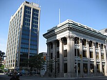
- Bank of Montreal Building (Hamilton) (converted to a National Law firm office)
- Landed Banking and Loan Company building
- Exchange Building (site of the first telephone exchange in the British Empire)
- John Sopinka Courthouse
- Hamilton Courthouse
- Landmark Place (Hamilton's tallest building)
- First Place Hamilton
- Don Cherry's Grapevine site
- St. Patrick Church
- St. Patrick Elementary School
- Cathedral Secondary School
- Columbia Elementary School
- Gage Park
- Hamilton Children's Museum (inside Gage Park)
- Gage Park Bandshell (concert stage)
- Gage Park fountain
- Memorial Elementary School
- Ottawa Street Shopping District - "Textile District"
- Delta Secondary School
- Montgomery Park
- Burlington Synchronized Swimming Club
- Queenston Traffic Circle (Queenston Road branches off from this point)
- Sir Winston Churchill Park
- Sir Winston Churchill Secondary School
- Parkdale Park
- Parkdale Arena
- Roxborough Park
Communities[]


Note: Listing of neighbourhoods from West to East.[8]
- Ainslie Wood
- Westdale
- Strathcona/ Kirkendall North
- Central/ Durand
- Beasley/ Corktown
- Landsdale/ Stinson
- Gibson/ St. Clair
- Stipley/ Blakeley
- Crown Point West/ Delta West
- Crown Point East/ Delta East
- Homeside/ Bartonville
- Normanhurst
- McQuesten West
Gallery[]

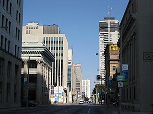
Corner of Main & Ottawa Streets
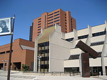
Hamilton Place

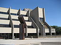
Hamilton Place/ Convention Centre


References[]
- ^ Manson, Bill (2003). Footsteps In Time: Exploring Hamilton's heritage neighbourhoods. North Shore Publishing Inc. ISBN 1-896899-22-6.
- ^ "Chronology of the Regional Municipality of Hamilton-Ontario". Retrieved 2007-03-26.
- ^ a b Houghton, Margaret (2003). The Hamiltonians, 100 Fascinating Lives. James Lorimer & Company Ltd., Publishers Toronto. p. 6. ISBN 1-55028-804-0.
- ^ Houghton, Margaret (2006). Vanished Hamilton Calendar. North Shore Publishing. ISBN 1-896899-39-0.
- ^ "McMaster's Economic Impact on the Hamilton Community". McMaster University. Archived from the original on 2006-11-13. Retrieved 2007-04-23.
- ^ "Celebrity High: Westdale Secondary Alumni" (Press release). The Hamilton Spectator. 2006-05-19. Archived from the original on 2007-09-30. Retrieved 2007-04-21.
- ^ Bailey, Thomas Melville (1981). Dictionary of Hamilton Biography (Vol I, 1791-1875). W.L. Griffin Ltd.
- ^ "Hamilton Neighbourhood Boundaries, (map.hamilton.ca)" (PDF). Archived from the original (PDF) on 2007-09-27. Retrieved 2007-05-11.
- MapArt Golden Horseshoe Atlas - Page 646/647/648 - Grids H5, J5, J6, J7, J8, H8, H9, H10, G10, G11, G12, G13, G14, G15, G16, G17, G18, G19
External links[]
| Wikimedia Commons has media related to Main Street (Hamilton, Ontario). |
- Roads in Hamilton, Ontario