Malaspina Glacier
| Malaspina Glacier | |
|---|---|
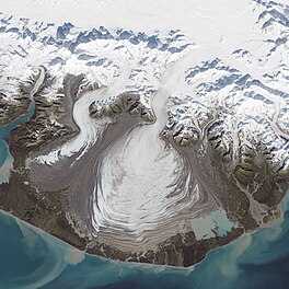 Malaspina Glacier captured by Landsat 8 on September 24, 2014 | |
| Type | Piedmont |
| Location | Alaska |
| Coordinates | 59°55′09″N 140°31′58″W / 59.91917°N 140.53278°WCoordinates: 59°55′09″N 140°31′58″W / 59.91917°N 140.53278°W |
| Area | 3,900 km2 (1,500 sq mi) |
| Length | 45 km (28 mi) |
| Thickness | 600 meters (2,000 ft) |
| Designated | 1969 |

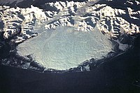
The Malaspina Glacier (Lingít: Sít' Tlein) in southeastern Alaska is the largest piedmont glacier in the world. Situated at the head of the Alaska Panhandle, it is about 65 km (40 mi) wide and 45 km (28 mi) long, with an area of some 3,900 km2 (1,500 sq mi).[1] It is named in honor of Alessandro Malaspina, a Tuscan explorer in the service of the Spanish Navy, who visited the region in 1791. In 1874, W.H. Dall, of what is now the U.S. National Geodetic Survey, bestowed the name "Malaspina Plateau" on it, not realizing its true geological character.[2]
It arises where several valley glaciers, primarily the and Agassiz Glacier, spill out from the Saint Elias Mountains onto the coastal plain facing the Gulf of Alaska between Icy Bay and Yakutat Bay.[1] Although it fills the plain, nowhere does it actually reach the water and so does not qualify as a tidewater glacier.
The Malaspina is up to 600 meters (2,000 ft) thick in places, with the elevation of its bottom being estimated to be as much as 300 m (980 ft) below sea level.[3] There are two lakes on its margins: to the northwest, at the foot of the between the Agassiz and Seward glaciers, and to the southeast, close to Yakutat Bay.
Radar data and aerial photographs dating back to 1972 provide evidence that the Malaspina-Seward glacier system lost about 20 m (66 ft) of its thickness between 1980 and 2000; because the glacier is so large, that amount of shrinkage was sufficient to contribute 1/2 of one percent of the rise in the global sea level.[4]
Nearly all of the glacier is encompassed by the southeast lobe of the Wrangell-St. Elias National Park and Preserve.
In October 1969, the glacier became a National Natural Landmark.[5]
See also[]
| Wikimedia Commons has media related to Malaspina Glacier. |
- List of National Natural Landmarks
- List of glaciers
Notes[]
- ^ Jump up to: a b Scheffel, Richard L.; Wernet, Susan J., eds. (1980). Natural Wonders of the World. United States of America: Reader's Digest Association, Inc. p. 222. ISBN 0-89577-087-3.
- ^ U.S. Geological Survey Geographic Names Information System: Malaspina Glacier
- ^ NASA.gov
- ^ Rozell, Ned. 2000 February 2. "Malaspina Melting, But Still Bigger than Rhode Island". Alaska Science Forum, Article #1476. Geophysical Institute, University of Alaska Fairbanks.
- ^ "National Natural Landmarks - National Natural Landmarks (U.S. National Park Service)". www.nps.gov. Retrieved 2019-03-20.
External links[]
| Authority control |
|---|
- Glaciers of Alaska
- National Natural Landmarks in Alaska
- Glaciers of Yakutat City and Borough, Alaska
- Wrangell–St. Elias National Park and Preserve