Malvinas Basin
| Malvinas Basin | |
|---|---|
| Cuenca de Malvinas | |
 | |
| Coordinates | 51°30′S 63°30′W / 51.500°S 63.500°W |
| Etymology | Islas Malvinas |
| Location | Argentine Shelf, Southern Atlantic |
| Region | Patagonia |
| Country | |
| State(s) | Santa Cruz Province Falkland Islands |
| Characteristics | |
| On/Offshore | Offshore |
| Boundaries | (W) Scotia-South American plate boundary (S) |
| Part of | Circum-Atlantic basins |
| Area | ~180,000 km2 (69,000 sq mi) |
| Hydrology | |
| Sea(s) | Southern Atlantic Ocean |
| Geology | |
| Basin type | Rift basin |
| Orogeny | Break-up of Pangea |
| Age | Early Jurassic-Holocene |
| Stratigraphy | Stratigraphy |
| Field(s) | non-commercial |
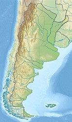
The Malvinas Basin (Spanish: Cuenca de Malvinas) is a major sedimentary basin in the Argentine Shelf offshore southern Patagonia. The basin borders to the west with the that separates it from the Magallanes Basin.[1] The southern boundary is formed by the Scotia plate boundary.[2] Contrary to the neighbouring North Falkland and Magallanes Basins, the Malvinas Basin is not known to have commercial hydrocarbon reserves.[3]
Tectonic history[]
The Malvinas Basin started to form with the break-up of Pangea since the Early Jurassic.
Stratigraphy[]
Though poorly understood due to the lack of well data, several formations were identified in the basin on the basis of 2D seismic, of which some also crop out in onshore Patagonia and the Austral Basin:[4]
| Age | Formation | Lithologies |
|---|---|---|
| Neogene | undefined | Claystones and sandstones |
| Paleogene | & | Sandstones and claystones |
| Late Cretaceous | & | Claystones and sandstones |
| Early Cretaceous | & | Claystones and sandstones |
| Late Jurassic | ||
| Middle Jurassic | Tobífera Formation | Volcanics and claystones |
| Early Jurassic | Hiatus | |
| Paleozoic | Basement | Quartzites and shales |
See also[]
- List of fossiliferous stratigraphic units in the Falkland Islands
- Geology of the Falkland Islands
- Golfo San Jorge Basin
- Antarctic Peninsula
References[]
Bibliography[]
- ; ; ; ; , and . 2013. New insights into the tectono-stratigraphic evolution of the Malvinas Basin, offshore of the southernmost Argentinean continental margin. Tectonophysics 604. 280–295. Accessed 2018-09-06.
- , and . s.a. South Malvinas/Falkland Basin: hydrocarbon migration and petroleum system, 1–53. _. Accessed 2018-09-06.
- . 2014. Seismic sequence stratigraphy of a foreland unit inthe [sic] Magallanes-Austral Basin, Dorado Riquelme Block, Chile: Implications for deep-marine reservoirs. Latin American Journal of Sedimentology and Basin Analysis, Asociación Argentina de Sedimentología 1221. 49–64. Accessed 2018-09-06.
Categories:
- Sedimentary basins of Argentina
- Geology of Santa Cruz Province, Argentina
- Geology of the Atlantic Ocean
- Geography of the Falkland Islands


