Manitoba Highway 8
 | ||||
|---|---|---|---|---|
| Veterans Memorial Highway, McPhillips Street | ||||
| Route information | ||||
| Maintained by Manitoba Infrastructure | ||||
| Length | 162 km[1] (101 mi) | |||
| Major junctions | ||||
| South end | ||||
| North end | Hecla-Grindstone Provincial Park | |||
| Location | ||||
| Districts | Unorganized Division No. 18 | |||
| Rural municipalities | ||||
| Major cities | Winnipeg | |||
| Highway system | ||||
| ||||
Provincial Trunk Highway 8 (PTH 8) is a provincial primary highway located in the Canadian province of Manitoba. It runs from the north limit of the City of Winnipeg, where it meets with Route 180 (McPhillips Street), north to Hecla-Grindstone Provincial Park. The highway between Winnipeg and PR 230 is known as McPhillips Street. At PR 230, McPhillips Street becomes McPhillips Road and continues along PR 230 to PTH 9 (Selkirk Bypass). The route is a major road connecting Winnipeg with the communities of Winnipeg Beach and Gimli. The speed limit is 100 km/h (60 mph).
Photo gallery[]

PTH 8 at St. Andrews
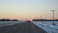
PTH 8 at St. Andrews


Major intersections[]
| Division | Location | km[1] | mi | Destinations | Notes |
|---|---|---|---|---|---|
| City of Winnipeg | 0.0 | 0.0 | Emes Road | Winnipeg city limits; PTH 8 southern terminus; continues as Route 180 | |
| West St. Paul | | 1.1 | 0.68 | Interchange; PTH 101 exit 69 | |
| 2.1 | 1.3 | ||||
| 6.6 | 4.1 | ||||
| St. Andrews | | 9.3 | 5.8 | Former PTH 8A | |
| 11.2 | 7.0 | North end of McPhillips Street designation | |||
| 19.1 | 11.9 | Former PR 223 | |||
| 30.6 | 19.0 | Clandeboye Road | Former PR 515 east | ||
| 37.1 | 23.1 | Petersfield Road – Petersfield | Former PR 413 | ||
| 47.0 | 29.2 | Former PR 228 | |||
| 61.0 | 37.9 | ||||
| ↑ / ↓ | | 61.0 | 37.9 | ||
| Gimli | | 64.3 | 40.0 | ||
| Gimli | 75.9 | 47.2 | |||
| | 84.1 | 52.3 | |||
| 87.3 | 54.2 | Lake Forest Road | Former PR 324 west | ||
| Bifrost – Riverton | | 105.4 | 65.5 | ||
| Riverton | 115.3 | 71.6 | |||
| | 127.4 | 79.2 | |||
| No. 18 | 139.6 | 86.7 | |||
| 162.2 | 100.8 | unnamed road | PTH 8 northern terminus | ||
1.000 mi = 1.609 km; 1.000 km = 0.621 mi
| |||||
References[]
- ^ a b Google (August 9, 2017). "PTH 8 in Manitoba" (Map). Google Maps. Google. Retrieved August 9, 2017.
External links[]
- Official Name and Location - Declaration of Provincial Trunk Highways Regulation - The Highways and Transportation Act - Provincial Government of Manitoba
- Official Highway Map - Published and maintained by the Department of Infrastructure - Provincial Government of Manitoba (see Legend and Map#3 & 5)
- Google Maps Search - Provincial Trunk Highway 8
Route map:

| ( • help)
|
This Manitoba road, road transport or highway-related article is a stub. You can help Wikipedia by . |
Categories:
- Manitoba provincial highways
- Manitoba road stubs