Manoppello
Manoppello | |
|---|---|
| Comune di Manoppello | |
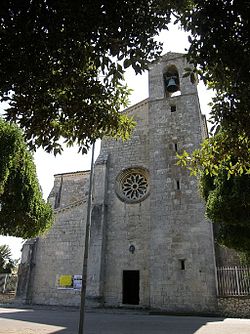 Church of Santa Maria Arabona | |
 Coat of arms | |
show Location of Manoppello | |
 Manoppello Location of Manoppello in Italy | |
| Coordinates: 42°15′29″N 14°03′36″E / 42.25806°N 14.06000°ECoordinates: 42°15′29″N 14°03′36″E / 42.25806°N 14.06000°E | |
| Country | Italy |
| Region | Abruzzo |
| Province | Pescara (PE) |
| Frazioni | Manoppello Scalo, Ripacorbaria, Santa Maria Arabona |
| Government | |
| • Mayor | Giorgio De Luca |
| Area | |
| • Total | 39.26 km2 (15.16 sq mi) |
| Elevation | 217 m (712 ft) |
| Population (28 February 2017)[2] | |
| • Total | 6,994 |
| • Density | 180/km2 (460/sq mi) |
| Demonym(s) | Manoppellesi |
| Time zone | UTC+1 (CET) |
| • Summer (DST) | UTC+2 (CEST) |
| Postal code | 65024, 65025, 65020 |
| Dialing code | 085 |
| Patron saint | Manoppello Image |
| Saint day | Third Monday in May |
| Website | Official website |


Manoppello (Abruzzese: Manuppèlle) is a comune in Abruzzo, in the province of Pescara, south-eastern Italy.
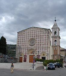
Church of the Volto Santo di Manoppello, housing the Holy Face image.
It is famous for having a church which contains an image on a thin byssus veil, a sudarium, known as the Holy Face of Manoppello and which has been reputed to be identical to the Veil of Veronica.

Veil of Veronica.
Other sights include is the Romanesque abbey of Santa Maria Arabona.
Twin towns[]
References[]
- ^ "Superficie di Comuni Province e Regioni italiane al 9 ottobre 2011". Istat. Retrieved 16 March 2019.
- ^ "Popolazione Residente al 1° Gennaio 2018". Istat. Retrieved 16 March 2019.
External links[]
| Wikimedia Commons has media related to Manoppello. |
- Inside Abruzzo - Insider tips uncovered
- Volto Santo di Manoppello Veil, Polish website
- Sudarium Christi The Face of Christ online audio visual featuring texts by sudarium expert Sr. Blandina Paschalis Schlömer et al.
- The Rediscovered Face - 1 first of four installments of an audiovisual presentation relating the holy image with a number of ancient predecessors, YouTube, access date March 2013.
| show Authority control |
|---|
This Abruzzo location article is a stub. You can help Wikipedia by . |
Categories:
- Cities and towns in Abruzzo
- Municipalities of the Province of Pescara
- Abruzzo geography stubs