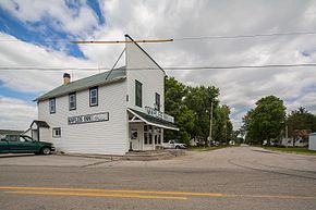
Maples, Indiana
Maples, Indiana | |
|---|---|
 | |
 Maples | |
| Coordinates: 41°00′46″N 84°58′09″W / 41.01278°N 84.96917°WCoordinates: 41°00′46″N 84°58′09″W / 41.01278°N 84.96917°W | |
| Country | United States |
| State | Indiana |
| County | Allen |
| Township | Jefferson |
| Elevation | 797 ft (243 m) |
| Time zone | UTC-5 (Eastern (EST)) |
| • Summer (DST) | UTC-4 (EDT) |
| ZIP code | 46816 |
| Area code(s) | 260 |
| GNIS feature ID | 438581 |


Maples is an unincorporated community in Jefferson Township, Allen County, in the U.S. state of Indiana.[2]
History[]
A post office was established at Maples in 1854, and remained in operation until it was discontinued in 1921.[3] The community was named for Lewis S. Maples, a lumber baron.[4]
Geography[]
Maples is located at 41°00′46″N 84°58′09″W / 41.01278°N 84.96917°W.
References[]
- ^ "US Board on Geographic Names". United States Geological Survey. 2007-10-25. Retrieved 2008-01-31.
- ^ "Maples, Indiana". Geographic Names Information System. United States Geological Survey. Retrieved February 16, 2020.
- ^ "Allen County". Jim Forte Postal History. Retrieved 27 August 2014.
- ^ Griswold, Bert Joseph; Taylor, Mrs. Samuel R. (1917). The Pictorial History of Fort Wayne, Indiana: A Review of Two Centuries of Occupation of the Region about the Head of the Maumee River. Robert O. Law Company. p. 644.
External links[]
 Media related to Maples, Indiana at Wikimedia Commons
Municipalities and communities of Allen County, Indiana, United States | ||
|---|---|---|
| Cities | ||
| Towns | ||
| Townships | ||
| CDPs | ||
| Other unincorporated communities |
| |
| Footnotes | ‡This populated place also has portions in an adjacent county or counties | |
| ||
This Allen County, Indiana location article is a stub. You can help Wikipedia by . |
Categories:
- Unincorporated communities in Allen County, Indiana
- Unincorporated communities in Indiana
- Fort Wayne, IN Metropolitan Statistical Area
- Northeast Indiana geography stubs