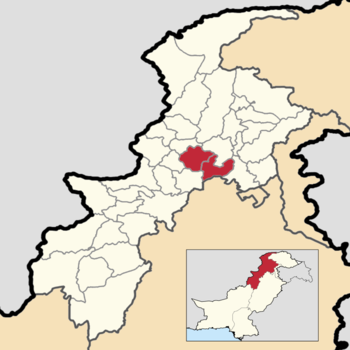
Mardan Division
Mardan Division | |
|---|---|
Division | |
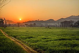 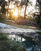  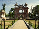  Images, from top down, left to right: Fields and mountains in Swabi District; A sunset near Swabi; Swat Expressway at Mardan; Guides' Memorial in Mardan; A lake in Swabi District | |
 | |
 Mardan Division Location within Pakistan | |
| Coordinates: 34°1′00″N 72°2′00″E / 34.01667°N 72.03333°ECoordinates: 34°1′00″N 72°2′00″E / 34.01667°N 72.03333°E | |
| Country | |
| Province | |
| Area | |
| • Total | 3,175 km2 (1,226 sq mi) |
| Population | |
| • Total | 3,997,677 |
| • Density | 1,300/km2 (3,300/sq mi) |
| Time zone | UTC+5 (PST) |
| National Assembly Seats (2018) [3] | Total (5)
|
| Khyber Pakhtunkhwa Assembly Seats (2018) [4] | Total (13)
|


Mardan Division is one of seven divisions in Pakistan's Khyber Pakhtunkhwa province. It consists of two districts: Mardan and Swabi.[5] According to the 2017 Pakistani Census, the division had a population of 3,997,667,[2] making it the fourth-most populous division in the province, but it only spans 3,175 km2 (1,226 sq mi) of area,[1] which makes it the smallest division by area in the province as well. Mardan, with over 350,000 people, is the division's namesake and most populous city. The division borders Hazara Division, Malakand Division, and Peshawar Division. The division does not have a single public airport.
Districts[]
Districts are the administrative unit one level below divisions in the administrative hierarchy of Pakistan. Mardan Division consists of the following two districts: [5]
| District | Population (2017) [2] | Total Area [1] | Population Density (2017) | Map |
|---|---|---|---|---|
| Mardan District | 2,373,061 | 1,632 km2 (630 sq mi) | 1,454.08/km2 (3,766.0/sq mi) | 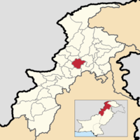 |
| Swabi District | 1,624,616 | 1,543 km2 (596 sq mi) | 1,052.89/km2 (2,727.0/sq mi) | 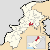 |
| Mardan Division | 3,997,677 | 3,175 km2 (1,226 sq mi) | 1,259.11/km2 (3,261.1/sq mi) |
History[]
The area which covers Mardan Division today was carved out of Peshawar District between the 1931 and 1941 censuses of British India.[6] The newly demarcated area was a Trans-Indus district called Mardan District. It consisted of two tehsils, Mardan Tehsil and Swabi Tehsil, which would later become the two districts that make up Mardan Division today.
This setup continued until One Unit, a geopolitical policy that abolished the provinces making up West Pakistan and consolidated West Pakistan into one province. After the One Unit policy ended in 1970 and the provinces returned with their original forms, the divisions that had been created as a result of the policy stayed in the North-West Frontier Province, which meant Mardan District stayed in Peshawar Division.
The area received full-fledged division status between the Pakistani censuses of 1981 and 1998, and during the same time period, Swabi Tehsil was also upgraded, to district status (becoming Swabi District). [1]
In August 2000, the division was abolished along with every other division in the country, but was reinstated (with all the other divisions of Pakistan) eight years later after the elections of 2008.
Geography[]
Mardan Division has a total area of 3,175 km2 (1,226 sq mi).[1] The area of the division is split rather evenly across both districts, with Mardan District taking up 51.4% of the area of the division (1,632 km2 (630 sq mi)), and Swabi District takes up the remaining 1,543 km2 (596 sq mi).
The division borders the important Indus River to its south and east, and has an abundance of natural beauty.
Surrounding areas[]
To Mardan Division's north and northwest, you will find Malakand Division, to the division's west and southwest, Peshawar Division can be found. To the southeast of Mardan Division, Rawalpindi Division in the province of Punjab can be found, and Mardan Division borders the Hazara Division to its east.
Demographics[]
| Year | Pop. | ±% p.a. |
|---|---|---|
| 1941 | 544,226 | — |
| 1951 | 629,374 | +1.46% |
| 1961 | 813,840 | +2.60% |
| 1972 | 1,204,253 | +3.63% |
| 1981 | 1,506,500 | +2.52% |
| 1998 | 2,486,904 | +2.99% |
| 2017 | 3,997,667 | +2.53% |
| Source: [6][1] [2] | ||
Mother Tongues of Mardan Division as of 1998. [7]
As of the 2017 Census of Pakistan, the division had a population of 3,997,667,[2] out of which there were 2,016,397 males, 1,981,159 females, and 121 people who identified as Transgender; this made the sex ratio of the division 1,018 males for every 1,000 females. The division had 526,077 households, making the average household size of the division 7.60; 715,250 people in the division lived in an urban area, but the vast majority (3,282,427) lived in a rural area, making the urbanization rate of the division 17.89%[8] While geographically, it is the smallest division in the province of Khyber Pakhtunkhwa, it is the most densely populated, with a population density of 1,259.11/km2 (3,261.1/sq mi), making it the fourth-most populated division in the province.
The largest city in Mardan Division is its namesake, Mardan. Mardan had a population of 358,604 in 2017[9] and was the second-largest city in the entire province (after Peshawar) at the time. Swabi was the second-largest city in the division, and it had a population of 123,412[10] and was the eighth-largest city in the province. The next three most-populous cities in the division were Takht-i-Bahi, in Mardan District, with a population of 80,721,[9] Topi, in Swabi District, with a population of 52,983,[10] and Tordher, in Swabi District, with a population of 41,420.[10] The whole division had seven municipalities in 2017, with five of them being concentrated in Swabi District.[10][9]
The division has one cantonment, the Mardan Cantonment, adjacent to the city of Mardan which had a population of 6,871, making up the division's entire military population.[9] This made only 0.17% of the entire population of the division active military personnel (one of the smallest military-civilian ratios in all of Pakistan).[citation needed]
In 1998, the dominant language in the division was Pashto, with over 97% of the population speaking it as their mother tongue.[7]
In 2014 - 2015, Mardan Division had a literacy rate of roughly 51%, below the national average of 60%, and just below the provincial average of 53%.[11]
Climate[]
The climate of Mardan Division varies depending on where you are in the division. In the western part of the division, towards Mardan District and the city of Mardan, the summers are hot, the winters are mild and dry, and little rainfall falls through the year. Here the climate is classified as a BSh (or a hot semi-arid climate) by the Köppen climate classification. [12] In the eastern part of the division, towards Swabi District and the city of Swabi, the summers are hot and long and the winters are dry and cool. Here the climate is classified as a Cwa (or a humid subtropical climate) by the Köppen classification. [13]
| hideClimate data for Mardan | |||||||||||||
|---|---|---|---|---|---|---|---|---|---|---|---|---|---|
| Month | Jan | Feb | Mar | Apr | May | Jun | Jul | Aug | Sep | Oct | Nov | Dec | Year |
| Average high °C (°F) | 17.7 (63.9) |
19.0 (66.2) |
24.0 (75.2) |
30.1 (86.2) |
36.3 (97.3) |
41.4 (106.5) |
38.5 (101.3) |
36.5 (97.7) |
35.3 (95.5) |
31.6 (88.9) |
25.1 (77.2) |
19.4 (66.9) |
29.6 (85.2) |
| Daily mean °C (°F) | 10.0 (50.0) |
12.2 (54.0) |
17.2 (63.0) |
22.7 (72.9) |
28.2 (82.8) |
33.2 (91.8) |
32.3 (90.1) |
31.0 (87.8) |
28.8 (83.8) |
23.2 (73.8) |
16.2 (61.2) |
11.0 (51.8) |
22.2 (71.9) |
| Average low °C (°F) | 2.3 (36.1) |
5.5 (41.9) |
10.4 (50.7) |
15.3 (59.5) |
20.2 (68.4) |
25.1 (77.2) |
26.2 (79.2) |
25.5 (77.9) |
22.3 (72.1) |
14.9 (58.8) |
7.4 (45.3) |
2.7 (36.9) |
14.8 (58.7) |
| Average rainfall mm (inches) | 47 (1.9) |
53 (2.1) |
67 (2.6) |
44 (1.7) |
20 (0.8) |
17 (0.7) |
88 (3.5) |
122 (4.8) |
45 (1.8) |
12 (0.5) |
14 (0.6) |
30 (1.2) |
559 (22.2) |
| Source: Climate-Data.org [12] | |||||||||||||
| hideClimate data for Swabi | |||||||||||||
|---|---|---|---|---|---|---|---|---|---|---|---|---|---|
| Month | Jan | Feb | Mar | Apr | May | Jun | Jul | Aug | Sep | Oct | Nov | Dec | Year |
| Average high °C (°F) | 17.7 (63.9) |
19.4 (66.9) |
24.4 (75.9) |
30.1 (86.2) |
36.1 (97.0) |
41.0 (105.8) |
38.0 (100.4) |
36.0 (96.8) |
35.0 (95.0) |
31.7 (89.1) |
25.5 (77.9) |
19.7 (67.5) |
29.6 (85.2) |
| Daily mean °C (°F) | 10.2 (50.4) |
12.7 (54.9) |
17.5 (63.5) |
22.7 (72.9) |
28.0 (82.4) |
32.9 (91.2) |
31.8 (89.2) |
30.4 (86.7) |
28.4 (83.1) |
23.4 (74.1) |
16.9 (62.4) |
11.7 (53.1) |
22.2 (72.0) |
| Average low °C (°F) | 2.8 (37.0) |
6.0 (42.8) |
10.6 (51.1) |
15.3 (59.5) |
20.0 (68.0) |
24.9 (76.8) |
25.7 (78.3) |
24.8 (76.6) |
21.9 (71.4) |
15.1 (59.2) |
8.3 (46.9) |
3.8 (38.8) |
14.9 (58.9) |
| Average rainfall mm (inches) | 55 (2.2) |
58 (2.3) |
69 (2.7) |
47 (1.9) |
23 (0.9) |
25 (1.0) |
110 (4.3) |
137 (5.4) |
58 (2.3) |
14 (0.6) |
12 (0.5) |
31 (1.2) |
639 (25.3) |
| Source: Climate-Data.org [13] | |||||||||||||
See also[]
- Divisions of Pakistan
- Divisions of Khyber Pakhtunkhwa
- Bannu Division
- Dera Ismail Khan Division
- Hazara Division
- Kohat Division
- Malakand Division
- Peshawar Division
- Mardan District
- Mardan
- Swabi District
- Swabi
- Administrative units of Pakistan
- Districts of Khyber Pakhtunkhwa
References[]
- ^ Jump up to: a b c d e f "1951 - 1998 POPULATION OF ADMINISTRATIVE UNITS (AS ON 1st MARCH 1998)" (PDF). 1951-98 Population of Administrative Units (As on 1st March, 1998).pdf. POPULATION CENSUS ORGANIZATION STATISTICS DIVISION GOVERNMENT OF PAKISTAN. January 2002. Archived (PDF) from the original on 23 August 2020. Retrieved 25 August 2020.
- ^ Jump up to: a b c d e "PROVINCE WISE PROVISIONAL RESULTS OF CENSUS - 2017" (PDF). PAKISTAN TEHSIL WISE FOR WEB CENSUS_2017.pdf. Pakistan Bureau of Statistics. Archived from the original (PDF) on 16 June 2020. Retrieved 16 June 2020.
- ^ "The Gazette of Pakistan Election Commission of Pakistan Notification" (PDF). National Assembly1.pdf. Election Commission of Pakistan. Archived from the original (PDF) on 21 June 2020. Retrieved 21 June 2020.
- ^ "The Gazette of Pakistan Election Commission of Pakistan Notification" (PDF). Provincial KPK1.pdf. Election Commission of Pakistan. Archived from the original (PDF) on 21 June 2020. Retrieved 21 June 2020.
- ^ Jump up to: a b "KP govt notifies new divisions following FATA merger". KP govt notifies new divisions following FATA merger | Pakistan Today. Pakistan Today. 20 July 2018. Archived from the original on 2 July 2020. Retrieved 2 July 2020.
- ^ Jump up to: a b Scott, I.D. "CENSUS OF INDIA, 1941 VOLUME X" (PDF). North-West Frontier Province, Volume X. Government of India. Archived (PDF) from the original on 22 June 2020. Retrieved 22 June 2020.
- ^ Jump up to: a b "Demobase". United States Census Bureau Demobase. Retrieved 4 September 2020.
- ^ "TABLE - 1: PROVISIONAL PROVINCE WISE POPULATION BY SEX AND RURAL/URBAN CENSUS - 2017 PAKISTAN" (PDF). DISTRICT_WISE_CENSUS_RESULTS_CENSUS_2017.pdf. Pakistan Bureau of Statistics. Archived from the original (PDF) on 21 June 2020. Retrieved 21 June 2020.
- ^ Jump up to: a b c d "POPULATION AND HOUSEHOLD DETAIL FROM BLOCK TO DISTRICT LEVEL KHYBER PAKHTUNKHWA (MARDAN DISTRICT)" (PDF). MARDAN_BLOCKWISE.pdf. Pakistan Bureau of Statistics. 3 January 2018. Archived from the original (PDF) on 22 June 2020. Retrieved 22 June 2020.
- ^ Jump up to: a b c d "POPULATION AND HOUSEHOLD DETAIL FROM BLOCK TO DISTRICT LEVEL KHYBER PAKHTUNKHWA (SWABI DISTRICT)" (PDF). SWABI_BLOCKWISE.pdf. Pakistan Bureau of Statistics. 3 January 2018. Archived from the original (PDF) on 23 June 2020. Retrieved 23 June 2020.
- ^ "PSLM –2014-15 PAKISTAN SOCIAL AND LIVING STANDARDS MEASUREMENT SURVEY (2014-15)" (PDF). PSLM_2014-15_National-Provincial-District_report.pdf. Pakistan Bureau of Statistics. Archived (PDF) from the original on 24 June 2020. Retrieved 24 June 2020.
- ^ Jump up to: a b "MARDAN CLIMATE (PAKISTAN)". Mardan climate: Average Temperature, weather by month, Mardan weather averages - Climate-Data.org. climate-data.org. Retrieved 2 August 2020.
- ^ Jump up to: a b "SWABI CLIMATE (PAKISTAN)". Swabi climate: Average Temperature, weather by month, Mardan weather averages - Climate-Data.org. climate-data.org. Retrieved 2 August 2020.
| show Pakistan articles |
|---|
| hide Districts of Khyber Pakhtunkhwa | ||
|---|---|---|
Provincial capital: Peshawar | ||
| Bannu |
|  |
| Dera Ismail Khan |
| |
| Hazara |
| |
| Kohat |
| |
| Malakand |
| |
| Mardan |
| |
| Peshawar |
| |
- Divisions of Pakistan