Outline of Pakistan

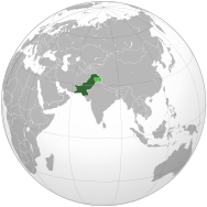

An enlargeable map of the Islamic Republic of Pakistan
The following outline is provided as an overview of and topical guide to Pakistan:
Pakistan – sovereign country located in South Asia.[1] It has a 1,046 kilometres (650 mi) coastline along the Arabian Sea and Gulf of Oman in the south and is bordered by Afghanistan in the west, Iran in the southwest, India in the east and China in the far northeast.[2]
General reference[]
- Pronunciation: /ˌpɑːkɪˈstɑːn/
- Common English country name: Pakistan
- Official English country name: The Islamic Republic of Pakistan
- Common endonym(s):
- Official endonym(s): Pakistan Islamabad
- Adjectival(s): Pakistani
- Demonym(s): Pakistani
- Etymology: Name of Pakistan
- International rankings of Pakistan
- ISO country codes: PK, PAK, 586
- ISO region codes: See ISO 3166-2:PK
- Internet country code top-level domain: .pk
Geography of Pakistan[]

Pakistan Map
- Pakistan is:
- Country | Middle Power
- Sovereign state | Member of Organization of Islam
- Location:
- Eastern Hemisphere
- Northern Hemisphere
- Eurasia
- Asia
- South Asia
- Iranian Plateau
- Indian subcontinent
- South Asia
- Asia
- Eurasia
- Time in Pakistan
- Time zone:Pakistan Standard Time (UTC+05)
- Extreme points of Pakistan
- High: K2 8,611 m (28,251 ft) – second highest peak on Earth
- Low: Arabian Sea 0 m (0 ft)
- Land boundaries: 7,307 km km
 India 3,323 km km
 Afghanistan 2,430 km
 Iran 959 km
 China 595 km
- Coastline: 1,146 km | (Arabian Sea | Indian Ocean)
- Population of Pakistan: 219,347,294 (Census 2017) – 6th most populous country
- Area of Pakistan: 881,913 km2 (340,509 sq mi) – 33rd largest country
- Atlas of Pakistan
- Subcontinent (Indian subcontinent)
- List of cities in Pakistan
- List of Union Councils in Pakistan
Environment of Pakistan[]

An enlargeable satellite image of Pakistan
- Climate of Pakistan
- Environmental issues in Pakistan
- Ecoregions in Pakistan
- Renewable energy in Pakistan
- Geology of Pakistan
- Protected areas of Pakistan
- Wildlife of Pakistan
- Flora of Pakistan
- Fauna of Pakistan
- Birds of Pakistan
- Mammals of Pakistan
- Fish of Pakistan
- Amphibians of Pakistan
- Reptiles of Pakistan
Geographic features of Pakistan[]
- Glaciers of Pakistan
- Islands of Pakistan
- Lakes of Pakistan
- Mountains of Pakistan
- Rivers of Pakistan
- Valleys of Pakistan
- List of World Heritage Sites in Pakistan
Administrative divisions of Pakistan[]
Provinces and territories Of Pakistan[]
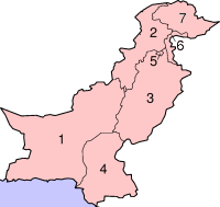
Pakistan's administrative units
- Provinces of Pakistan
- By name:
- Punjab, Pakistan
- Sindh
- Khyber Pakhtunkhwa
- Balochistan, Pakistan
- By name:
- Territories of Pakistan
- Azad Kashmir
- Gilgit-Baltistan
- Islamabad
Divisions of Pakistan[]

Map of District and Tehsils in Pakistan
- Divisions of Punjab, Pakistan
- Bahawalpur | Dera Ghazi Khan | Faisalabad | Gujranwala | Lahore | Multan | Rawalpindi | Sahiwal | Sargodha | Sheikhupura
- Divisions of Sindh
- | Hyderabad | Karachi | Sukkur | Larkana | Mirpur Khas | Shaheed Benazirabad
- Divisions of Khyber Pakhtunkhwa
- Divisions of Balochistan, Pakistan
- Kalat | Makran | Naseerabad | Quetta | | Sibi | Zhob
- Divisions of Azad Kashmir
- Mirpur | Muzaffarabad | Poonch
- Divisions of Gilgit-Baltistan
- Baltistan | Gilgit | Diamer
Districts of Pakistan[]
Municipalities of Pakistan[]

Islamabad skyline
- Capital of Pakistan: Islamabad
- Cantonment (Pakistan)
- Cities of Pakistan
Demography of Pakistan[]
Government and politics of Pakistan[]

- Form of government:Sovereign socialistSovereign Socialist Secular Federal Parliamentary Multi-party Representative Democratic Republic.
- Capital of Pakistan: Islamabad
- Elections in Pakistan
- 1954 (indirect elections) = ML
- 1962 (non-party based indirect elections)
- 3rd elections : 1970 = AL
- 4th elections : 1977 = PPP
- 5th elections : 1985 = PML
- 6th elections : 1988 = PPP
- 7th elections : 1990 = IJI
- 8th elections : 1993 = PPP
- 9th elections : 1997 = PMLN
- 10th elections : 2002 = PMLQ
- 11th elections : 2008 = PPP
- 12th elections : 2013 = PMLN
- 13th elections : 2018 = PTI
- Political parties in Pakistan
- Awami National Party

- Jamaat-e-Islami Pakistan

- Jamiat Ulema-e-Islam (F)

- Muttahida Qaumi Movement

- Pakistan Muslim League (N)
- Pakistan Peoples Party

- Pakistan Tehreek-e-Insaf
- Pak Sarzameen Party
- Tehreek-e-Labbaik Pakistan
- Awami National Party
Branches of the government of Pakistan[]
Executive of the government of Pakistan[]
- Head of state: President of Pakistan
- Head of government: Prime Minister of Pakistan
- Part of Government: Cabinet of Pakistan | Cabinet Secretary of Pakistan
Legislature of the government of Pakistan[]
- Parliament of Pakistan
- Senate of Pakistan (Aiwān-e-Bālā Pākistān) - upper house of the parliament (Chairman of the Senate of Pakistan)
- National Assembly (Aiwān-e-Zairīñ Pākistān ) - lower house of the parliament (Speaker of the National Assembly of Pakistan)
Judiciary of the government of Pakistan[]
- Supreme Court of Pakistan (Chief Justice of Pakistan)
- High Courts of Pakistan
- District Courts of Pakistan
Foreign relations of Pakistan[]
- Diplomatic missions in Pakistan
- Diplomatic missions of Pakistan
- India-Pakistan relations
International organization membership[]
The Islamic Republic of Pakistan is a member of:[1]
|
|
Law and order in Pakistan[]
- Capital punishment in Pakistan
- Constitution of Pakistan
- Crime in Pakistan
- Human rights in Pakistan
- Law enforcement in Pakistan
Pakistani Armed Forces[]
- Command
- Commander-in-chief:President of Pakistan
- Ministry of Defence of Pakistan
- National Security Council (Pakistan)
- Minister of Defence (Pakistan)
- Defence Secretary of Pakistan
- Joint Chiefs of Staff Committee
- Chief of Army Staff (Pakistan)
- Chief of Naval Staff (Pakistan)
- Chief of Air Staff (Pakistan)
- Forces
- Pakistan Army
- Pakistan Navy
- Pakistan Air Force
- Inter-Services Intelligence
- Special Service Group
- Special Service Group (Navy)
- Pakistan Marines
- Special Services Wing
- Special Support Group
- Inter-Services Public Relations
- Inter-Services Selection Board
- Khyber Border Coordination Center
- Strategic Plans Division Force
- Pakistan Armed Forces Band
- Paramilitary forces of Pakistan
- National Guard of Pakistan
- Maritime Security Agency
- Pakistan Rangers
- Frontier Corps
- Pakistan Coast Guards
- Frontier Constabulary
- Gilgit Baltistan Scouts
- Anti-Narcotics Force
- Airports Security Force
Local government in Pakistan[]
History of Pakistan[]
- Ancient Civilizations
- Indus Valley Civilization (3300–1700 BCE)
- Late Harappan culture (1700–1300 BCE)
- Islamic empires (1206–1858)
- Delhi Sultanate (1206–1596)
- Mughal Empire (1526–1858)
- Colonial India (1858–1947)
- Pakistan Movement
- Two-nation theory (Pakistan)
- Partition of India (1947)
- Timeline of Pakistani history (1947–present)
- History of the Islamic Republic of Pakistan
- Economic history of Pakistan
- Military history of Pakistan
Culture of Pakistan[]
- Architecture of Pakistan
- Cuisine of Pakistan
- Ethnic minorities in Pakistan
- Languages of Pakistan
- Media in Pakistan
- National symbols of Pakistan
- Coat of arms of Pakistan
- Flag of Pakistan
- National anthem of Pakistan
- People of Pakistan
- Prostitution in Pakistan
- Public holidays in Pakistan
- Religion in Pakistan
- Buddhism in Pakistan
- Christianity in Pakistan
- Hinduism in Pakistan
- Islam in Pakistan
- Judaism in Pakistan
- Sikhism in Pakistan
- List of World Heritage Sites in Pakistan
- Tribes in Balochistan
- Category:Punjabi tribes
- Tribes in North-West Frontier Province
- Tribes in Punjab
-
- Baloch people
- Hazara people
- Tribes in Sindh
-
- Balti people
- Shina people
- Burusho people
- Dard people
- Domba
- Yashkuns
Art in Pakistan[]
- Cinema of Pakistan
- Literature of Pakistan
- Music of Pakistan
- Television in Pakistan
- Theatre in Pakistan
Sports in Pakistan[]
- Pakistan men's national field hockey team
- Cricket in Pakistan
- Polo in Pakistan
- Football in Pakistan
- Squash in Pakistan
- Billiards in Pakistan
- Tour de Pakistan
- Pakistan national kabaddi team
- Pakistan at the Olympics
- National Participation: National Games of Pakistan
- International Participation: Pakistan at the Commonwealth Games | Pakistan at the Asian Games | South Asian Games | Cricket World Cup | Men's FIH Hockey World Cup
Economy and infrastructure of Pakistan[]
- Economic rank, by nominal GDP (2019): 40th (forty)
- Agriculture in Pakistan
- Banking in Pakistan
- National Bank of Pakistan
- Communications in Pakistan
- Companies of Pakistan
- Currency of Pakistan: Rupee
- ISO 4217: PKR
- Economic history of Pakistan
- Energy in Pakistan
- Health care in Pakistan
- Mining in Pakistan
- Pakistan Stock Exchange
- Tourism in Pakistan
- Transport in Pakistan
- Airports in Pakistan
- Rail transport in Pakistan
- Roads in Pakistan
- Water supply and sanitation in Pakistan
Education in Pakistan[]
See also[]
| Urdu language edition of Wikipedia, the free encyclopedia |
| Western Punjabi language edition of Wikipedia, the free encyclopedia |
| Sindhi language edition of Wikipedia, the free encyclopedia |
| Pashto language edition of Wikipedia, the free encyclopedia |
| Kashmiri language edition of Wikipedia, the free encyclopedia |
| English language edition of Wikipedia, the free encyclopedia |
Pakistan
- Ba'ab-ul-Islam
- List of international rankings
- List of Pakistan-related topics
- Member state of the Commonwealth of Nations
- Member state of the United Nations
- Outline of Asia
- Outline of geography
References[]
- ^ Jump up to: a b "Pakistan". The World Factbook. United States Central Intelligence Agency. July 2, 2009. Retrieved July 23, 2009.
- ^ The entire Kashmir region is claimed by Pakistan, including Jammu and Kashmir. China also administers part of the region with the Indian and Pakistani-held areas defined by the Line of Control.Pakistan refers to Jammu and Kashmir as "Indian-Occupied Kashmir".
External links[]
Pakistanat Wikipedia's sister projects
 Definitions from Wiktionary
 Media from Wikimedia Commons
 News from Wikinews
 Quotations from Wikiquote
 Texts from Wikisource
 Textbooks from Wikibooks
 Resources from Wikiversity
- Government of Pakistan
- The President of Pakistan
- The Ministry of Information and Broadcasting
 Pakistan travel guide from Wikivoyage
- Outline of Pakistan at Curlie
Categories:
- Pakistan
- Pakistan-related lists
- Outlines of countries