Marion County Lake
| Marion County Lake | |
|---|---|
 Marion County Lake | |
 | |
| Location | Marion County, Kansas |
| Coordinates | 38°19′14″N 96°59′07″W / 38.3206708°N 96.9852588°WCoordinates: 38°19′14″N 96°59′07″W / 38.3206708°N 96.9852588°W |
| Type | Lake |
| Primary outflows | Cottonwood River |
| Basin countries | United States |
| Managing agency | Marion County |
| Built | 1937 |
| Surface area | 300 acres (1.2 km2) |
| Surface elevation | 1,335 feet (407 m) |
| Settlements | Marion |
| References | [1] |

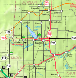
Marion County Lake is a body of water, 1.5 miles (2.4 km) south-east of Marion at 170th Street, on the western edge of the Flint Hills region of Kansas in the United States.[1]
This smaller lake is often confused with the similar named yet larger Marion Reservoir, which is north-west of Marion. Most locals refer to the larger body of water using the term 'Reservoir', and the smaller body of water using the term 'Lake' (this article).
Geography[]
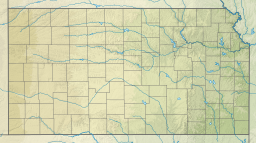
Marion County Lake is located at coordinates 38.3206708, -96.9852588 in the scenic Flint Hills and Great Plains of the state of Kansas.[1] There are three entrances into the lake area. The north entry is 1 mile east of Marion on K-256 / 190th Street / Main Street, then 1.75 miles south on Upland Road. The east entry is 3/4 mile west of U.S. Route 77 on 170th Street. The west entry is rural un-paved county roads of 170th Street or Turkey Creek Road.
History[]
Early history[]
For many millennia, the Great Plains of North America was inhabited by nomadic Native Americans. From the 16th century to 18th century, the Kingdom of France claimed ownership of large parts of North America. In 1762, after the French and Indian War, France secretly ceded New France to Spain, per the Treaty of Fontainebleau.
19th century[]
In 1802, Spain returned most of the land to France. In 1803, most of the land for modern day Kansas was acquired by the United States from France as part of the 828,000 square mile Louisiana Purchase for 2.83 cents per acre.
In 1854, the Kansas Territory was organized, then in 1861 Kansas became the 34th U.S. state. In 1855, Marion County was established within the Kansas Territory, which included the land for modern day Lake.[2]
20th century[]
In 1937, Marion County Lake was completed by the Civilian Conservation Corps for the purpose of recreation.
21st century[]
In 2002, it was listed on the National Register of Historic Places (NRHP).
In 2012, an event was held at the park to set the Guinness World Record for the "most people roasting marshmallows at once". The official count was 1,272 people.[3]
Education[]
The community is served by Marion–Florence USD 408 public school district.
Infrastructure[]
Utilities[]
- Internet
- Satellite is provided by HughesNet, StarBand, WildBlue.
- TV
- Satellite is provided by DirecTV, Dish Network.
- Terrestrial is provided by regional digital TV stations.
- Electricity is provided by Flint Hills RECA.
- Trash is provided by City of Florence.
See also[]
References[]
Further reading[]
External links[]
- Marion County Lake, official website
- Marion County Lake, KansasFlintHills.travel
- National Register of Historic Places
- Historical
- Marion County cemetery list, archive of KsGenWeb
- Marion County history bibliography, Marion County school bibliography, Kansas Historical Society
- Maps
- Marion County maps: Current, Historic, KDOT
- Topo Map of Marion to Florence area, USGS
Municipalities and communities of Marion County, Kansas, United States | ||
|---|---|---|
| Cities |  | |
| Unincorporated communities | ||
| Ghost towns | ||
| Townships | ||
| Footnotes | †This populated place is designated a Census-Designated Place (CDP) by the United States Census Bureau. ‡This populated place also has portions in an adjacent county or counties | |
| ||
- County parks in the United States
- Lakes of Kansas
- Protected areas of Marion County, Kansas