Marlow Lagoon, Northern Territory
| Marlow Lagoon Darwin, Northern Territory | |||||||||||||||
|---|---|---|---|---|---|---|---|---|---|---|---|---|---|---|---|
 Marlow in the west of the City of Palmerston | |||||||||||||||
 Marlow Lagoon | |||||||||||||||
| Coordinates | 12°29′54″S 130°57′52″E / 12.498405°S 130.964515°ECoordinates: 12°29′54″S 130°57′52″E / 12.498405°S 130.964515°E | ||||||||||||||
| Population | 721 (2016 census)[1] | ||||||||||||||
| Established | 1990s | ||||||||||||||
| Postcode(s) | 0830 | ||||||||||||||
| Location |
| ||||||||||||||
| LGA(s) | City of Palmerston | ||||||||||||||
| Territory electorate(s) | Goyder | ||||||||||||||
| Federal division(s) | Solomon | ||||||||||||||
| |||||||||||||||
| Footnotes | Adjoining suburbs[2][3] | ||||||||||||||

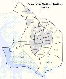
Marlow Lagoon is an outer western suburb of Palmerston 24 km SE of the Darwin CBD. Its local government area is the City of Palmerston. Marlow Lagoon is bounded to the west by the Adelaide-Darwin Railway, and to the east by .
The suburb is named after Joseph Marlow, a railway maintenance worker who had an interest in an agricultural lease (no. 213) spanning the nearby peninsula between Berrimah and Palmerston. [1].
References[]
- ^ Australian Bureau of Statistics (27 June 2017). "Marlow Lagoon (State Suburb)". 2016 Census QuickStats. Retrieved 28 June 2017.

- ^ "Search result for 'Marlow Lagoon'". NT Atlas and Spatial Data Directory. Northern Territory Government. Retrieved 10 June 2019.
- ^ "Palmerston City Council Suburbs" (PDF). Place Names Committee. Northern Territory Government. Retrieved 10 June 2019.
External links[]
Categories:
- Suburbs of Darwin, Northern Territory