City of Palmerston
| City of Palmerston Northern Territory | |||||||||||||||
|---|---|---|---|---|---|---|---|---|---|---|---|---|---|---|---|
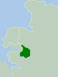 Location within Darwin metropolitan area | |||||||||||||||
| Population | 37,862 (2018)[1] | ||||||||||||||
| • Density | 718.4/km2 (1,860.8/sq mi) | ||||||||||||||
| Established | 1981 | ||||||||||||||
| Area | 52.7 km2 (20.3 sq mi)[1] | ||||||||||||||
| Mayor | Athina Pascoe-Bell[2] | ||||||||||||||
| Council seat | Palmerston City | ||||||||||||||
| Region | Outer Darwin | ||||||||||||||
| Territory electorate(s) | Blain, Brennan, Drysdale, Spillett | ||||||||||||||
| Federal Division(s) | Solomon | ||||||||||||||
| Website | City of Palmerston | ||||||||||||||
| |||||||||||||||
| Footnotes | Adjoining LGAs[3] | ||||||||||||||
The City of Palmerston is a local government area of the Northern Territory of Australia. It contains the suburbs of Darwin's satellite city, Palmerston, and is situated between the outer industrial areas of Darwin and the rural areas of Howard Springs. The City covers an area of 52.7 square kilometres (20.3 sq mi) and in June 2018 had a population of 37,862.[1]
The Palmerston City Council consists of the Mayor and seven aldermen. The city is not divided into wards, thus each alderman represents constituents from the entire city. Council elections are held in August every four years. The next election is in 2021.
History[]
The City of Palmerston was incorporated in 1981 under the Local Government Act (NT), and in 2000 was proclaimed the Northern Territory's second city.
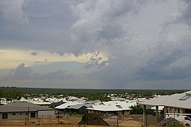
Suburbs[]
Suburbs of the inner city and of the outskirts, with post codes in parenthesis:
| Suburbs Map | Inner City | Outskirts |
|---|---|---|
 |
Sister cities[]
Communications between the City of Palmerston and Kupang ceased in 2009 and a letter from previous Mayor, Robert Macleod was sent to the Mayor of Kupang advising him that Council had decided not to enter into a new agreement with the City of Kupang.[4]
References[]
- ^ Jump up to: a b c "3218.0 – Regional Population Growth, Australia, 2017-18: Population Estimates by Local Government Area (ASGS 2018), 2017 to 2018". Australian Bureau of Statistics. Australian Bureau of Statistics. 27 March 2019. Retrieved 25 October 2019. Estimated resident population, 30 June 2018.
- ^ https://www.palmerston.nt.gov.au/council/about-council/your-elected-members/mayor-athina-pascoe-bell
- ^ "Palmerston City Council Suburbs" (PDF). Northern Territory Government. Archived from the original (PDF) on 18 March 2019. Retrieved 22 May 2019.
- ^ "Archived copy" (PDF). Archived from the original (PDF) on 15 March 2017. Retrieved 12 September 2017.CS1 maint: archived copy as title (link)
External links[]
| Authority control |
|
|---|
Coordinates: 12°29′38″S 130°58′54″E / 12.4939°S 130.9818°E

- Populated places established in 1981
- 1981 establishments in Australia
- Local government areas of the Northern Territory
- Darwin, Northern Territory