Mary's Corner, Washington
Mary's Corner, Washington | |
|---|---|
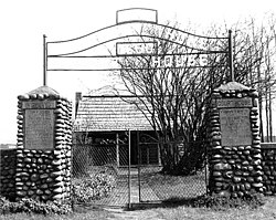 Jackson Courthouse near Mary's Corner, Washington | |
 Mary's Corner | |
| Coordinates: 46°32′52″N 122°49′21″W / 46.54769920102858°N 122.82261863283233°W | |
| Country | United States |
| State | Washington |
| County | Lewis |
| Elevation | 538 ft (164 m) |
| Time zone | UTC-8 (Pacific (PST)) |
| • Summer (DST) | UTC-7 (PDT) |
| ZIP code | 98532 |
| Area code(s) | 360 |
| GNIS feature ID | 1511127[1] |


Mary's Corner is an unincorporated community located in Lewis County, Washington. The area sits at the crossroads of U.S. Route 12 and Jackson Highway (once the Pacific and National Parks Highway intersection).[2] The community is 11.2 miles south of Chehalis and 4.2 miles west of the town of Ethel. The 616 acres (249 ha) Lewis and Clark State Park is directly south of the community. The John R. Jackson House, listed on the National Register of Historic Places, and a state park, is located in the town.
The name is taken from Mary Loftis, an owner of a restaurant located in the area beginning in the late 1880s.[a] The area's first non-Native settler, John R. Jackson, set up the first county seat in his log cabin in 1851, also becoming the first federal court in the newly formed Washington Territory in 1854. The town, referred to at the time as the Highlands, would remain the county seat until it was moved to Claquato in 1858.[3]
Notes[]
- ^ Newspaper reports in the area first start using the term, "Mary's Corner", in 1928.
References[]
- ^ "Mary's Corner". Geographic Names Information System. United States Geological Survey.
- ^ "Plan To Build Church At Mary's Corner". The Chehalis Bee-Nugget. August 29, 1930. p. 11. Retrieved 22 December 2021.
- ^ Mittge, Brian (April 6, 2002). "If Towns Could Talk : Mary's Corner". The Chronicle. p. 23. Retrieved 22 December 2021.
Municipalities and communities of Lewis County, Washington, United States | ||
|---|---|---|
| Cities |  | |
| Town | ||
| CDPs | ||
| Other communities | ||
| Ghost towns | ||
| Flooded towns |
| |
| Indian reservation | ||
| Footnotes | ‡This populated place also has portions in an adjacent county or counties | |
| ||
- Populated places in Lewis County, Washington
- Unincorporated communities in Lewis County, Washington
- Unincorporated communities in Washington (state)