Lewis and Clark State Park (Washington)
| Lewis and Clark State Park | |
|---|---|
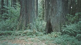 Old growth in Lewis and Clark | |
 Location in the state of Washington | |
| Location | Lewis, Washington, United States |
| Coordinates | 46°31′29″N 122°48′55″W / 46.52472°N 122.81528°WCoordinates: 46°31′29″N 122°48′55″W / 46.52472°N 122.81528°W[1] |
| Area | 616 acres (249 ha) |
| Elevation | 453 ft (138 m)[1] |
| Established | 1922 |
| Operator | Washington State Parks and Recreation Commission |
| Website | Lewis and Clark State Park |

Lewis and Clark State Park is a public recreation area located six miles (9.7 km) northeast of Winlock in Lewis County, Washington. The state park occupies one of the last major stands of old-growth forest in the state. The park's 616 acres (249 ha) include camping areas and trails for hiking and horseback riding. Evidence of the efforts of the Civilian Conservation Corps to improve the park in the 1930s can be found in the park's rustic shelters and restroom facilities.[2]
References[]
- ^ a b "Lewis and Clark State Park". Geographic Names Information System. United States Geological Survey.
- ^ "Lewis and Clark State Park". Washington State Parks and Recreation Commission. Retrieved November 6, 2018.
External links[]
| Wikimedia Commons has media related to Lewis and Clark State Park (Washington). |
- Lewis and Clark State Park Washington State Parks and Recreation Commission
- Lewis and Clark State Park Map Washington State Parks and Recreation Commission
Categories:
- State parks of Washington (state)
- Parks in Lewis County, Washington
- Protected areas established in 1922
- Civilian Conservation Corps in Washington (state)