Olympic Coast National Marine Sanctuary
| Olympic Coast National Marine Sanctuary | |
|---|---|
IUCN category IV (habitat/species management area) | |
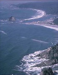
 Aerial view of Teahwhit Head and James Island | |
| Location | Western Washington state |
| Coordinates | 48°00′N 124°48′W / 48°N 124.8°WCoordinates: 48°00′N 124°48′W / 48°N 124.8°W |
| Area | 3,189 sq mi (8,260 km2)[1] |
| Established | 1994 |
| Governing body | National Oceanic and Atmospheric Administration |

The Olympic Coast National Marine Sanctuary is one of 14 marine sanctuaries administered by the National Oceanic and Atmospheric Administration (NOAA), an agency of the U.S. Department of Commerce. It is located along the Olympic Peninsula of Washington state. The sanctuary was declared in 1994 and encompasses 3,189 square miles (8,260 km2) of the Pacific Ocean from Cape Flattery in the north, to the mouth of the Copalis River, a distance of about 162.5 miles (261.5 km).[1] Extending 25 to 40 miles (40 to 64 km) from the shore, it includes most of the continental shelf, as well as parts of three important submarine canyons, the , the Quinault Canyon and the Juan de Fuca Canyon. For 64 miles (103 km) along the coast, the sanctuary shares stewardship with the Olympic National Park.[1] The sanctuary overlays the Flattery Rocks, Quillayute Needles, and Copalis Rock National Wildlife Refuges.[2]
References[]
- ^ Jump up to: a b c "Mapping". Olympic Coast National Marine Sanctuary.
- ^ "Sanctuary Fact Sheet". Olympic Coast National Marine Sanctuary.
External links[]
 Map of the sanctuary |
 Olympic Coast National Marine Sanctuary |
| show Protected areas of Washington |
|---|
| show Authority control |
|---|
- IUCN Category IV
- Protected areas of Clallam County, Washington
- Protected areas of Grays Harbor County, Washington
- Protected areas of Jefferson County, Washington
- National Marine Sanctuaries of the United States
- Protected areas established in 1994
- 1994 establishments in Washington (state)