Mashavera
| Mashavera | |
|---|---|
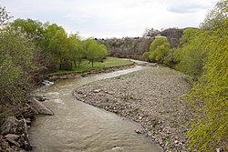 The Mashavera in Bolnisi | |
| Native name | მაშავერა (Georgian) |
| Location | |
| Country | Georgia |
| Physical characteristics | |
| Mouth | Khrami |
• coordinates | 41°26′11″N 44°42′54″E / 41.4364°N 44.7150°ECoordinates: 41°26′11″N 44°42′54″E / 41.4364°N 44.7150°E |
| Length | 66 km (41 mi) |
| Basin size | 1,390 km2 (540 sq mi) |
| Basin features | |
| Progression | Khrami→ Kura→ Caspian Sea |

The Mashavera (Georgian: მაშავერა) is a river of southern Georgia. It is 66 km (41 mi) long, and has a drainage basin of 1,390 km2 (540 sq mi).[1] It is a right tributary of the Khrami. It flows through the towns Dmanisi and Bolnisi.
References[]
| Wikimedia Commons has media related to Mashavera River. |
- ^ Statistical Yearbook of Georgia: 2020, National Statistics Office of Georgia, Tbilisi, 2020, p. 12.
Categories:
- Tributaries of the Kura (Caspian Sea)
- Rivers of Georgia (country)
- Asia river stubs
- Europe river stubs
- Georgia (country) geography stubs