Matsusaka
Matsusaka
松阪市 | |
|---|---|
 Traditional street in central Matsusaka | |
 Flag  Emblem | |
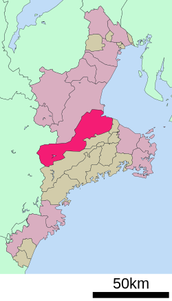 Location of Matsusaka in Mie Prefecture | |
 Matsusaka | |
| Coordinates: 34°34′40.6″N 136°31′39.3″E / 34.577944°N 136.527583°ECoordinates: 34°34′40.6″N 136°31′39.3″E / 34.577944°N 136.527583°E | |
| Country | Japan |
| Region | Kansai |
| Prefecture | Mie |
| Government | |
| • Mayor | Masato Takegami |
| Area | |
| • Total | 623.64 km2 (240.79 sq mi) |
| Population (August 2021) | |
| • Total | 157,235 |
| • Density | 250/km2 (650/sq mi) |
| Time zone | UTC+9 (Japan Standard Time) |
| Symbols | |
| • Tree | Pine |
| • Flower | Lilium auratum |
| • Bird | Japanese bush-warbler |
| Phone number | 0598-53-4311 |
| Address | 1340-1 Tonomachi, Matsusaka-shi, Mie-ken 515-8515 |
| Website | Official website |

Matsusaka (松阪市, Matsusaka-shi) is a city located in Mie Prefecture, Japan. As of 1 August 2021, the city had an estimated population of 157,235 in 66,018 households and a population density of 250 persons per km².[1] The total area of the city is 623.64 square kilometres (240.79 sq mi). The city is famous for Matsusaka beef.
Geography[]
Matsusaka is located in east-central Kii Peninsula, in central Mie Prefecture. It stretches the width of Mie Prefecture, and is bordered by Ise Bay on the Pacific Ocean to the east, and Nara Prefecture to the west. Parts of the city are within the limits of the Yoshino-Kumano National Park.
Neighboring municipalities[]
Mie Prefecture
Nara Prefecture
Climate[]
Matsusaka has a Humid subtropical climate (Köppen Cfa) characterized by warm summers and cool winters with light to no snowfall. The average annual temperature in Matsusaka is 15.4 °C. The average annual rainfall is 2015 mm with September as the wettest month. The temperatures are highest on average in August, at around 26.4 °C, and lowest in January, at around 4.7 °C.[2]
Demographics[]
Per Japanese census data,[3] the population of Matsusaka has been increasing slowly over the past 50 years.
| Year | Pop. | ±% |
|---|---|---|
| 1950 | 147,054 | — |
| 1960 | 141,245 | −4.0% |
| 1970 | 139,161 | −1.5% |
| 1980 | 153,185 | +10.1% |
| 1990 | 159,625 | +4.2% |
| 2000 | 164,504 | +3.1% |
| 2010 | 168,146 | +2.2% |
History[]
Matsusaka developed as a commercial center during the Sengoku period, and Oda Nobukatsu, the younger son of Oda Nobunaga built a castle in the area in 1580. The area came under the control of Gamō Ujisato shortly thereafter, and the Gamō began construction of a castle in the Yoiho forest (四五百森, Yoiho no mori) and named the site "Matsusaka," meaning "slope (坂) covered with pines (松)" in 1588. Matsusaka Castle was the center of the short-lived in the early Tokugawa shogunate, but for most of the Edo period, the castle was the eastern outpost of Kishu Domain based at Wakayama Castle.
Following the Meiji restoration, the area became part of Mie Prefecture. The town of Matsusaka was created on April 1, 1889 with the establishment of the modern municipalities system. The second kanji character of Matsusaka was changed to 阪 from 坂 in those days. On March 26, 1893, 1318 houses in the town were destroyed in a fire. Matsusaka was raised to city status on February 1, 1933. The city suffered only light damage in World War II, when an air raid killed four people on February 4, 1945. About 700 houses in the city were destroyed by a fire on December 16, 1951. On October 15, 1956, a major railway accident occurred at Rokken Station on the outskirts of the city, killing 42 people. On August 1, 1982, Typhoon Bess left nine people dead in its wake. The city officially celebrated its 500th anniversary in 1988.
On January 1, 2005, the city expanded to its present borders, with the absorption the towns of Mikumo and Ureshino (both from Ichishi District), and the towns of Iinan and Iitaka (both from Iinan District).
Government[]
Matsusaka has a mayor-council form of government with a directly elected mayor and a unicameral city council of 28 members. Matsusaka contributes four members to the Mie Prefectural Assembly. In terms of national politics, the city is part of Mie 1st district of the lower house of the Diet of Japan.
Education[]
Matsusaka has 36 public elementary schools and 12 public middle schools operated by the city government and four public high schools operated by the Mie Prefectural Board of Education. There are also one private middle school and two private high schools. The prefectural also operates two special education schools for the handicapped. Mie Chukyo University, formerly located in Matsusaka, closed in 2013.
Transportation[]
Railway[]
![]() Kintetsu Railway - Yamada Line
Kintetsu Railway - Yamada Line
Highway[]
 Ise Expressway
 National Route 23
 National Route 42
 National Route 166
 National Route 368
 National Route 422
Seaports[]
Sister city relations[]
 - Binhu District, Wuxi, Jiangsu Province, China[4]
Local attractions[]
- Matsusaka Castle ruins
- Takarazuka kofun ancient burial mound
- Azaka Castle ruins
Notable people[]
- Mitsui Takatoshi, founder of the Mitsui group.
- Motoori Norinaga,Edo period kokugaku scholar
- Matsuura Takeshirō, explorer, cartographer, writer, painter, priest, and antiquarian
- Tetsuo Morimoto, politician
- Masaharu Nakagawa, politician
- Kana Nishino,J-pop/R&B singer
- Norihisa Tamura, politician
- Ben Wada, film director
- Ikuzo Saito, Olympic wrestler
- Satoshi Hida, professional soccer player
- Keisuke Funatani, professional soccer player
- Mienoumi Tsuyoshi, sumo wrestler
- Hiroki Mizumoto, professional soccer player
- Yotsukasa Dai, sumo wrestler
- Aki Deguchi, J-pop idol and singer
References[]
- ^ "Matsusaka city official statistics" (in Japanese). Japan.
- ^ Matsusaka climate data
- ^ Matsusaka population statistics
- ^ "International Exchange". List of Affiliation Partners within Prefectures. Council of Local Authorities for International Relations (CLAIR). Archived from the original on 5 February 2016. Retrieved 21 November 2015.
External links[]
![]() Media related to Matsusaka, Mie at Wikimedia Commons
Media related to Matsusaka, Mie at Wikimedia Commons
- Official website (in Japanese)
- Matsusaka city guide from the Mie Guidebook at Mie JETs
| Special city | ||
|---|---|---|
| Cities | ||
| Districts | ||
Authority control | |
|---|---|
| General | |
| National libraries | |
| Scientific databases | |
| Other | |
- Matsusaka, Mie
- Cities in Mie Prefecture
- Populated coastal places in Japan
- Port settlements in Japan
- Populated places established in 1588