Maya (river)
| Maya | |
|---|---|
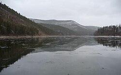 The Maya in October | |
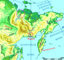 The Maya is the V-shaped tributary of the Aldan barely visible on this map. | |
| Location | |
| Country | Russia |
| Physical characteristics | |
| Source | |
| • location | Dzhugdzhur Mountains |
| • coordinates | 59°44′50″N 139°38′02″E / 59.7472°N 139.6339°E |
| Mouth | Aldan |
• coordinates | 60°24′22″N 134°33′06″E / 60.4062°N 134.5518°ECoordinates: 60°24′22″N 134°33′06″E / 60.4062°N 134.5518°E |
| Length | 1,087 km (675 mi) |
| Basin size | 171,000 km2 (66,000 sq mi) |
| Discharge | |
| • average | 1,180 m3/s (42,000 cu ft/s) |
| Basin features | |
| Progression | Aldan→ Lena→ Laptev Sea |

The Maya (Russian: Мая) is a river in Khabarovsk Krai and Sakha, Russia. It is a right tributary of the Aldan of the Lena basin. The length of the river is 1,053 kilometres (654 mi). The area of its basin 171,000 square kilometres (66,000 sq mi).[1] The Maya freezes up in late October and stays under the ice until May. The Yudoma is one of the biggest tributaries of the Maya. The river is navigable up to 500 kilometres (310 mi) upstream from its mouth.
The Yudoma-Maya Highlands are located in the basin of the Maya.[2]
The Maya was part of the river route from Yakutsk to the Okhotsk Coast. Its course is approximately "V"-shaped. The upper Maya runs about 201 kilometres (125 mi) southwest parallel to the coast between the Dzhugdzhur Mountains and the Yudoma Plateau. About 80 kilometres (50 mi) from its source the Mati River comes in from the south. From the Mati either the Lama Portage or the Alanchak Portage led to the Ulya and the coast. Near the southernmost point was the settlement of Nelkan from which a track led over the mountains to Ayan. The Maya flows west for perhaps 64 kilometres (40 mi) and receives the Maimakan River from the southwest. From here the river flows basically north about 320 kilometres (200 mi), receives the Yudoma from the east and joins the Aldan at Ust-Maya. From Ust-Maya there was a horse-track to Yakutsk. Eastbound boats that reached Ust-Maya from the Lena were replaced by smaller boats to continue up the Maya.
References[]
- ^ Река Мая (Майя) in the State Water Register of Russia (Russian)
- ^ Юдомо-Майское нагорье / Great Soviet Encyclopedia; in 35 vol.] / Ch. ed. Yu.S. Osipov . - M .: Great Russian Encyclopedia, 2004—2017.

This Sakha Republic location article is a stub. You can help Wikipedia by . |
This Khabarovsk Krai location article is a stub. You can help Wikipedia by . |
This article related to a river in Russia is a stub. You can help Wikipedia by . |
- Tributaries of the Aldan
- Rivers of the Sakha Republic
- Rivers of Khabarovsk Krai
- Sakha Republic geography stubs
- Russian Far East geography stubs
- Russia river stubs