McClary Glacier
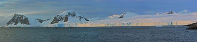
McClary Glacier ( WikiMiniAtlas68°4′S 67°0′W / 68.067°S 67.000°W / -68.067; -67.000) is a glacier 10 nautical miles (19 km) long and 2 nautical miles (4 km) wide on the west coast of Graham Land, Antarctica. It flows southwest along the north side of Butson Ridge into Marguerite Bay between Cape Calmette and the Debenham Islands. The glacier was first roughly surveyed by the British Graham Land Expedition, 1936–37, and resurveyed by the Falkland Islands Dependencies Survey, 1946–50. It was named by the UK Antarctic Place-Names Committee for , father of , mate on the Port of Beaumont during the Ronne Antarctic Research Expedition, 1947–48.[1]
Further reading[]
- Damien Gildea, Antarctic Peninsula - Mountaineering in Antarctica: Travel Guide
- CHRISTOPH SCHNEIDER, Monitoring climate variability on the Antarctic Peninsula by means of observations of the snow cover, Annals of Glaciology 27 1998, P 624
References[]
- ^ "McClary Glacier". Geographic Names Information System. United States Geological Survey. Retrieved 2013-09-04.
![]() This article incorporates public domain material from the United States Geological Survey document: "McClary Glacier". (content from the Geographic Names Information System)
This article incorporates public domain material from the United States Geological Survey document: "McClary Glacier". (content from the Geographic Names Information System)
Glaciers in the Antarctic | |
|---|---|
|
Glaciers of Graham Land | |
|---|---|
| Antarctic Peninsula |
|
| Adelaide Island |
|
| James Ross Island |
|
| Palmer Archipelago |
|
| Trinity Peninsula |
|
This article about a glacier in Fallières Coast is a stub. You can help Wikipedia by . |
- Glaciers of Fallières Coast
- Graham Land glacier stubs
- Fallières Coast geography stubs
- Coordinates on Wikidata
- Wikipedia articles incorporating text from the USGS Geographic Names Information System
- All stub articles