McGowan Peak
| McGowan Peak | |
|---|---|
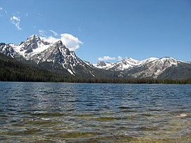 McGowan Peak and Stanley Lake | |
| Highest point | |
| Elevation | 9,860 ft (3,010 m) |
| Prominence | 1,100 ft (340 m)[1] |
| Parent peak | Alpine Peak |
| Coordinates | 44°12′48″N 115°04′51″W / 44.2132397°N 115.0809242°WCoordinates: 44°12′48″N 115°04′51″W / 44.2132397°N 115.0809242°W[2] |
| Geography | |
 McGowan Peak Custer County, Idaho, U.S. | |
| Parent range | Sawtooth Range |
| Topo map | USGS Stanley Lake |
| Climbing | |
| Easiest route | Scrambling, class 3 |

McGowan Peak (variant name McGown Peak), at 9,860 feet (3,010 m) above sea level is a peak in the Sawtooth Range of Idaho. The peak is located in the Sawtooth Wilderness of Sawtooth National Recreation Area in Custer County. The peak is located 3.25 mi (5.23 km) north-northwest of Alpine Peak, its line parent. McGowan Peak rises above the southwest end of Stanley Lake.[3][4][5]
References[]
- ^ "McGowan Peak, Idaho". Peakbagger.com. Retrieved January 4, 2013.
- ^ "McGowan Peak". Geographic Names Information System. United States Geological Survey. Retrieved January 4, 2013.
- ^ Sawtooth National Forest (Map) (1998 ed.). Sawtooth National Forest, U.S. Forest Service.
- ^ "McGown Peak". SummitPost.org. Retrieved January 4, 2013.
- ^ "McGowan Peak". Lists of John. Retrieved January 4, 2013.
This Geographical stub article in Custer County, Idaho is a stub. You can help Wikipedia by . |
Categories:
- Mountains of Custer County, Idaho
- Mountains of Idaho
- Sawtooth Wilderness
- Geography of Custer County, Idaho
- Custer County, Idaho geography stubs