Snowyside Peak
| Snowyside Peak | |
|---|---|
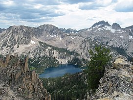 Snowyside Peak at right with Toxaway Lake | |
| Highest point | |
| Elevation | 10,651 ft (3,246 m)[1] |
| Prominence | 1,546 ft (471 m)[1] |
| Parent peak | Mount Cramer |
| Coordinates | 43°56′18″N 114°58′17″W / 43.9382372°N 114.9714666°WCoordinates: 43°56′18″N 114°58′17″W / 43.9382372°N 114.9714666°W[2] |
| Geography | |
 Snowyside Peak Blaine, Custer, and Elmore counties, Idaho, U.S. | |
| Parent range | Sawtooth Range |
| Topo map | USGS Snowyside Peak |
| Climbing | |
| Easiest route | Scramble, class 3 |

Snowyside Peak, at 10,651 feet (3,246 m) above sea level, is the fifth-highest peak in the Sawtooth Range of the U.S. state of Idaho. The peak is located in the Sawtooth Wilderness of Sawtooth National Recreation Area at the intersection of Blaine, Custer County, and Elmore counties. It is the highest point in Elmore County. The peak is located 5.1 miles (8.2 km) south of Mount Cramer, its line parent. It is the 217th-highest peak in Idaho.[3][4][5]
See also[]
- List of peaks of the Sawtooth Range (Idaho)
- List of mountains of Idaho
- List of mountain peaks of Idaho
- List of mountain ranges in Idaho
References[]
- ^ a b "Snowyside Peak, Idaho". Peakbagger.com. Retrieved January 3, 2013.
- ^ "Snowyside Peak". Geographic Names Information System. United States Geological Survey. Retrieved January 3, 2013.
- ^ "Snowyside Peak". SummitPost.org. Retrieved January 3, 2013.
- ^ "Snowyside Peak". Lists of John. Retrieved January 3, 2013.
- ^ Sawtooth National Forest (Map) (1998 ed.). Sawtooth National Forest, U.S. Forest Service.
Boise (capital) | ||
| Topics |  Seal of Idaho | |
| Society | ||
| Regions |
| |
| Larger cities |
| |
| Smaller cities |
| |
| Counties |
| |
This Boise County, Idaho state location article is a stub. You can help Wikipedia by . |
This Geographical stub article in Custer County, Idaho is a stub. You can help Wikipedia by . |
This Elmore County, Idaho state location article is a stub. You can help Wikipedia by . |
Categories:
- Mountains of Blaine County, Idaho
- Mountains of Custer County, Idaho
- Mountains of Elmore County, Idaho
- Mountains of Idaho
- Sawtooth Wilderness
- Boise County, Idaho geography stubs
- Geography of Custer County, Idaho
- Custer County, Idaho geography stubs
- Elmore County, Idaho geography stubs