Soldier Mountains
| Soldier Mountains | |
|---|---|
 Soldier Mountains from the north | |
| Highest point | |
| Peak | Smoky Dome |
| Elevation | 10,095 ft (3,077 m) |
| Coordinates | 43°29′36″N 114°56′11″W / 43.493236°N 114.936256°WCoordinates: 43°29′36″N 114°56′11″W / 43.493236°N 114.936256°W |
| Dimensions | |
| Length | 28 mi (45 km) E/W |
| Width | 14 mi (23 km) N/S |
| Geography | |
| Country | United States |
| State | Idaho |
| Parent range | Rocky Mountains |

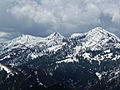
The Soldier Mountains are a mountain range in the U.S. state of Idaho, spanning northern Camas and eastern Elmore counties. The highest point in the range is Smoky Dome at 10,095 feet (3,077 m), and the range is bounded on the west and north by the South Fork Boise River.[1] The mountains are located within Sawtooth National Forest north of Fairfield, Idaho. The Soldier Mountain Ski Area is located within the range to the east of Smoky Dome.
Iron Mountain near the western end of the Soldier Mountains has an old Forest Service fire lookout on its summit. Several road and trails are located in the mountains, which provide for a variety of activities including hiking, off-road vehicle riding, fishing, and hunting. Most of the peaks can be accessed relatively easily via class one or two routes.
Peaks[]
| Mountain Peak | Elevation | Prominence | Isolation | Location |
|---|---|---|---|---|
| Smoky Dome | 10,095 ft 3077 m |
3,255 ft 992 m |
16.98 mi 27.3 km |
43°29′36″N 114°56′11″W / 43.493236°N 114.936256°W |
| 9,934 ft 3028 m |
407 ft 124 m |
0.63 mi 1.01 km |
43°30′00″N 114°55′39″W / 43.5001°N 114.9276°W | |
| 9,711 ft 2960 m |
972 ft 296 m |
5.46 mi 8.79 km |
43°31′43″N 115°02′01″W / 43.52874°N 115.033664°W | |
| Iron Mountain | 9,695 ft 2955 m |
514 ft 157 m |
0.89 mi 1.43 km |
43°32′17″N 115°02′42″W / 43.53810°N 115.04507°W |
| 9,665 ft 2946 m |
406 ft 124 m |
0.98 mi 1.58 km |
43°29′11″N 114°55′09″W / 43.48651°N 114.91929°W | |
| 9,528 ft 2904 m |
316 ft 96 m |
0.63 mi 1.01 km |
43°29′08″N 114°54′25″W / 43.48546°N 114.90701°W | |
| Boardman Peak | 9,455 ft 2882 m |
687 ft 209 m |
2.18 mi 3.51 km |
43°30′48″N 114°59′43″W / 43.51330°N 114.99532°W |
| 9,147 ft 2788 m |
unknown | unknown | 43°28′43″N 114°53′40″W / 43.47854°N 114.89452°W |
Lakes[]

Soldier Mountains

Solder Mountains from Camas Prairie Centennial Marsh

Soldier Mountains
Soldier Mountains

View northwest from Soldier Mountains


See also[]
References[]
- ^ Sawtooth National Forest. "Sawtooth National Forest" [map].1:126,720, 1"=2 miles. Twin Falls, Idaho: Sawtooth National Forest, United States Forest Service, 1998.
- ^ "Soldier Mountains". PeakBagger. Retrieved 2012-01-15.
External links[]
 Media related to Soldier Mountains at Wikimedia Commons
- U.S. Forest Service: official Sawtooth National Forest website
- Fairfeild Ranger District Trip Report
This Camas County, Idaho state location article is a stub. You can help Wikipedia by . |
This Elmore County, Idaho state location article is a stub. You can help Wikipedia by . |
- Ranges of the Rocky Mountains
- Mountain ranges of Idaho
- Landforms of Camas County, Idaho
- Landforms of Elmore County, Idaho
- Sawtooth National Forest
- Camas County, Idaho geography stubs
- Elmore County, Idaho geography stubs