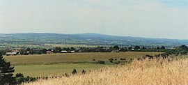
McLaren Vale, South Australia
| McLaren Vale South Australia | |||||||||||||||
|---|---|---|---|---|---|---|---|---|---|---|---|---|---|---|---|
 | |||||||||||||||
 McLaren Vale | |||||||||||||||
| Coordinates | 35°13′11″S 138°32′28″E / 35.219773°S 138.541119°ECoordinates: 35°13′11″S 138°32′28″E / 35.219773°S 138.541119°E[1] | ||||||||||||||
| Population | |||||||||||||||
| • Density | 794/km2 (2,056/sq mi) | ||||||||||||||
| Established | 1838[citation needed] 13 July 1995 (locality)[4] | ||||||||||||||
| Postcode(s) | 5171[5] | ||||||||||||||
| Area | 3.9 km2 (1.5 sq mi)[citation needed] | ||||||||||||||
| Time zone | ACST (UTC+9:30) | ||||||||||||||
| • Summer (DST) | ACST (UTC+10:30) | ||||||||||||||
| Location |
| ||||||||||||||
| LGA(s) | City of Onkaparinga[1] | ||||||||||||||
| Region | Southern Adelaide[6] | ||||||||||||||
| County | Adelaide[1] | ||||||||||||||
| State electorate(s) | Mawson[7] | ||||||||||||||
| Federal Division(s) | Mayo[8] | ||||||||||||||
| |||||||||||||||
| |||||||||||||||
| Footnotes | Locations[5][1] Adjoining localities[1] | ||||||||||||||

McLaren Vale is a town and locality in the Australian state of South Australia located about 33 kilometres (21 mi) south of the Adelaide city centre and about 9 kilometres (5.6 mi) south of the municipal seat at Noarlunga Centre.[5][1]
History[]
The township was formed in 1923 from a merging of the two original villages of Gloucester and Bellevue, which were established in the 1840s.[10][11] Boundaries for the locality were defined 13 July 1995 for the portion within the former City of Noarlunga with the portion in the former District Council of Willunga being added on 28 January 1999. Land within the former locality of Landcross Farm was added on 16 March 2000.[1][4][12][13]
The source of the name has been attributed by several writers to either David McLaren of the South Australian Company or John McLaren of the colonial government's Land Office. Geoff Manning, a South Australian historian, investigated this matter and found that the latter person is the namesake.[10]
South of Noarlunga the country along the coast (Aldinga Plains) is more thinly settled chiefly in consequence of a want of water. At two miles from the township, however, the traveller enters upon the extensive and rich valley of McLaren, named from Mr McLaren, Land Office, who surveyed it and most of the southern districts.
— The Country in South Australia, The South Australian, 7 October 1845[14]
Geography and demographics[]
The McLaren Vale wine region surrounds the town.
Former Newsboys frontman Peter Furler was born in McLaren Vale.
The Coast to Vines rail trail passes through McLaren Vale. There was a station at McLaren Vale on the former Willunga railway line that it follows.
The main road junction into the town, at Victor Harbor Road and Main Road, has over the years been notorious for fatal crashes. In 2011, construction started on an overpass, to remove the threat of right hand turns through high speed traffic. The overpass opened in late 2012.
There were two supermarkets in the town, a Foodland and a BI-LO (where Browse and Save currently operates), until Foodland was sold, and Bilo moved into the vacancy. In 2006, BI-LO converted to Coles along with the national conversion. In 2011, it was announced that the shopping centre would be undergoing an upgrade, with a Target Country.[15] Target Country will occupy the current Coles location, after a new, bigger Coles is built behind its current location. The complete shopping centre is expected to open in early 2013.[needs update]
At the 2016 census, the locality of McLaren Vale had a population of 3,842[3] of which 3,096 lived in its town centre.[2]
McLaren Vale is located within the federal division of Mayo, the state electoral district of Mawson and the local government area of the City of Onkaparinga.[8][7][1]
References[]
- ^ Jump up to: a b c d e f g h "Search results for 'McLaren Vale, LOCB' with the following datasets being selected – 'Suburbs and Localities', 'Counties', 'Government Towns', 'Hundreds', 'Local Government Areas', 'SA Government Regions', 'Gazetteer' and 'Roads'". Location SA Map Viewer. Government of South Australia. Retrieved 16 June 2018.
- ^ Jump up to: a b Australian Bureau of Statistics (27 June 2017). "McLaren Vale (Urban Centre)". 2016 Census QuickStats. Retrieved 3 February 2019.

- ^ Jump up to: a b Australian Bureau of Statistics (27 June 2017). "McLaren Vale (State Suburb)". 2016 Census QuickStats. Retrieved 3 February 2019.
- ^ Jump up to: a b Wotton, David (13 July 1995). "GEOGRAPHICAL NAMES ACT, 1991 Notice to Assign" (PDF). The. Government of South Australia. p. 61. Retrieved 2 February 2019.
- ^ Jump up to: a b c "Postcode for McLaren Vale, South Australia". Postcodes Australia. Retrieved 2 February 2019.
- ^ "Southern Adelaide SA Government region" (PDF). The Government of South Australia. Retrieved 17 April 2017.
- ^ Jump up to: a b Mawson 2018-2022 electoral district map (Map). Electoral District Boundaries Commission. 2016. Retrieved 7 August 2019.
- ^ Jump up to: a b "Federal electoral division of Mayo". Australian Electoral Commission. Retrieved 16 June 2018.
- ^ Jump up to: a b c "Monthly climate statistics: Summary statistics NOARLUNGA (nearest weather station)". Commonwealth of Australia , Bureau of Meteorology. Retrieved 2 February 2019.
- ^ Jump up to: a b Manning, Geoffrey. "South Australian Names - M" (PDF). Manning Index of South Australian History. State Library of South Australia. Retrieved 2 February 2019.
- ^ "McLaren Vale History". Kay Brothers. Retrieved 9 May 2019.
- ^ Kentish, P.M. (28 January 1999). "GEOGRAPHICAL NAMES ACT 1991 Notice to Assign Boundaries and Names to Places" (PDF). The South Australian Government Gazette. Government of South Australla. p. 611. Retrieved 2 February 2019.
- ^ Lawson, Robert (16 March 2000). "GEOGRAPHICAL NAMES ACT 1991 Notice to Assign a Name to a Place" (PDF). The South Australian Government Gazette. Government of South Australia. p. 1434. Retrieved 2 February 2019.
...alter the name of the suburb of Landcross Farm, as shown on the plan below, to McLaren Vale.
- ^ "The Country in South Australia". South Australian. VIII (667). South Australia. 7 October 1845. p. 2. Retrieved 2 February 2019 – via National Library of Australia.
- ^ Lucid Consulting, McLaren Vale Redevelopment Archived 13 October 2009 at the Wayback Machine
External links[]
291555293 McLaren Vale, South Australia on OpenStreetMap
| Authority control |
|
|---|
This article about a place in Adelaide is a stub. You can help Wikipedia by . |
- Towns in South Australia
- Suburbs of Adelaide
- Adelaide geography stubs