Međimurje (region)


Međimurje (pronounced [medʑǐmuːrje]; Hungarian: Muraköz) is a small historical and geographical region in Northern Croatia comprising the area between the two large rivers, Mura and Drava, and roughly corresponding to the administrative division of Međimurje County.
Overview[]
The region consists of the alluvial plain in its southeastern part (so called Dolnje Međimurje = The Lower Međimurje) and the slopes of the Alpine foothills in its northwestern part (Gornje Međimurje = the Upper Međimurje, or sometimes Međimurske gorice = approx. the Međimurje Hills). The highest geographical point is Mohokos, a 344,4 metre above sea level high peak of a short hill range that extends for about 20 kilometres across the northwestern part of the region in northwest-southeast direction. While the Upper Međimurje is covered with groves, meadows, vineyards and orchards, the Lower Međimurje is largely used for tillage, which includes fields of cereals, maize, potato, as well as vegetable farming.
Throughout the history, the region was inhabited since the Neolithic and Bronze Age. From the 1st century it was under the control of the Roman Empire and part of the province of Pannonia. In the Early Middle Ages the Slavs settled the region, which later became part of the Duchy of Pannonian Croatia, then Kingdom of Croatia and (from 1102) Kingdom of Croatia in personal union with Hungary.[1] From 1720 Međimurje was officially part of the Hungarian Zala County. During centuries it was possessed by many mighty noble families like Lacković, Celjski, Ernušt, Zrinski, Althann or Feštetić.
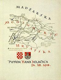
According to 1527 election in Cetin Međimurje fell under the Habsburg rule and remained until the end of the First World War in 1918, when it was. It was occupied in late December 1918, and proclaimed a part of the newly formed Kingdom of Serbs, Croats and Slovenes (later known as Yugoslavia) by a popular assembly held in the region's largest town Čakovec.[2] This was confirmed in the Treaty of Trianon. From 1991 the region is part of the Republic of Croatia.
See also[]
- Regions of Croatia
- History of Croatia
- Geography of Croatia
- Hungarian Revolution of 1848
- Međimurje horse
- Međimurska gibanica
- Sveta Jelena
References[]
- ^ [http://www.enciklopedija.hr/natuknica.aspx?id=39822 From 1720 Međimurje was officially part of the Hungarian Zala County
- ^ "9th January - Croatian Parliament Memorial Day". Retrieved 31 January 2018.
External links[]
- Text of the history of Međimurje in the Encyclopedia of the Miroslav Krleža Institute of Lexicography
- Međimurje – History, Identity and Migrations
- Međimurje in 1918
| Principal historical regions |  | ||||||||
|---|---|---|---|---|---|---|---|---|---|
| Smaller regions |
| ||||||||
| |||||||||
- Međimurje
- Historical regions in Croatia
- Historical regions in the Kingdom of Hungary