Istria
This article needs additional citations for verification. (January 2021) |


Istria (/ˈɪstriə/ ISS-tree-ə; Croatian, Slovene: Istra; Istriot: Eîstria; Istro Romanian: Istrie, Italian: Istria; German: Istrien, German: [ˈɪstʁiən] (![]() listen)), formerly Histria (Latin), Ἴστρια (Ancient Greek), is the largest peninsula within the Adriatic Sea. The peninsula is located at the head of the Adriatic between the Gulf of Trieste and the Kvarner Gulf. It is shared by three countries: Croatia, Slovenia, and Italy.[1][2] Croatia encapsulates most of the Istrian peninsula with its Istria County (Istarska županija in Croatian, Regione istriana in Italian).
listen)), formerly Histria (Latin), Ἴστρια (Ancient Greek), is the largest peninsula within the Adriatic Sea. The peninsula is located at the head of the Adriatic between the Gulf of Trieste and the Kvarner Gulf. It is shared by three countries: Croatia, Slovenia, and Italy.[1][2] Croatia encapsulates most of the Istrian peninsula with its Istria County (Istarska županija in Croatian, Regione istriana in Italian).
Geography[]
This section relies largely or entirely on a single source. (November 2015) |

The geographical features of Istria include the Učka mountain range, which is the highest portion of the Ćićarija mountain range; the rivers Dragonja, Mirna, , and Raša; and the Lim bay and valley. Istria lies in three countries: Croatia, Slovenia and Italy. By far the largest portion (89%) lies in Croatia. "Croatian Istria" is divided into two counties, the larger being Istria County in western Croatia. Important towns in Istria County include Pula, Poreč, Rovinj, Pazin, Labin, Umag, Motovun, Buzet, and Buje. Smaller towns in Istria County include Višnjan, Roč, and Hum.
The northwestern part of Istria lies in Slovenia: it is known as Slovenian Istria, and includes the coastal municipalities of Piran/Pirano, Izola, and Koper. It also includes the Karstic municipality of Hrpelje-Kozina.
Northwards of Slovenian Istria, there is a tiny portion of the peninsula that lies in Italy.[1][2] This smallest portion of Istria consists of the comunes of Muggia and San Dorligo della Valle with Santa Croce (Trieste) lying farthest to the north.
The ancient region of Histria extended over a much wider area, including the whole Kras plateau with the southern edges of the Vipava Valley, the southwestern portions of modern Inner Carniola with Postojna and Ilirska Bistrica, and the Italian Province of Trieste, but not the Liburnian coast which was already part of Illyricum.[3]
Climate[]
This section needs additional citations for verification. (January 2021) |
- Central Istria (Pazin) has a continental climate.
- The northern (or Slovenian and Italian) coast of Istria (Ankaran/Ancarano, Koper/Capodistria, Izola/Isola, Muggia/Milje) has a sub-Mediterranean climate.
- The western and southern coast (Piran/Pirano, Portorož/Portorose, Novigrad/Cittanova, Rovinj/Rovigno, Pula/Pola) has a Mediterranean climate.
- The eastern coast (Rabac/Porto Albona, Labin/Albona, Opatija/Abbazia) has a sub-Mediterranean climate with oceanic influences.
- The warmest places are Pula/Pola and Rovinj/Rovigno, while the coldest is Pazin/Pisino.
- Precipitation is moderate, with between 640 and 1,020 mm (25 and 40 in) falling in the coastal areas, and up to 1,500 mm (60 in) in the hills.
History[]
Early history[]

The name is derived from the Histri (Greek: Ἱστρών έθνος) tribes, which Strabo refers to as living in the region and who are credited as being the builders of the hillfort settlements (castellieri). The Histri are classified in some sources as a "Venetic" Illyrian tribe with certain linguistic differences from other Illyrians.[4] The Romans described the Histri as a fierce tribe of pirates, protected by the difficult navigation of their rocky coasts. It took two military campaigns for the Romans to finally subdue them in 177 BC. The region was then called together with the Venetian part the X. Roman Region of "Venetia et Histria", the ancient definition of the northeastern border of Italy. Dante Alighieri refers to it as well, the eastern border of Italy per ancient definition is the river Arsia. The eastern side of this river was settled by people whose culture was different than Histrians. Earlier influence of the Iapodes was attested there, while at some time between the 4th and 1st century BC the Liburnians extended their territory and it became a part of Liburnia.[5] On the northern side, Histria extended much further north and included the Italian city of Trieste.
Some scholars speculate that the names Histri and Istria are related to the Latin name Hister, or Danube (especially its lower course). Ancient folktales[citation needed] reported —inaccurately— that the Danube split in two or "bifurcated" and came to the sea near Trieste as well as at the Black Sea. The story of the "bifurcation of the Danube" is part of the Argonaut legend. There is also a suspected link (but no historical documentation in support of it) to the commune of Istria in Constanța, Romania which is named after the ancient city Histria, named after River Hister.
In the Dark Ages, Istria was conquered and occupied by the Goths. Ostrogoth coins were found in Istria, as well as the remains of some buildings. South of Poreč there are the remains of the church of Sv. Petar, erected in the 5th century (with a baptistery added later), which reportedly served the Arian eastern Goths ruling Istria.[6][7] Most notably, the Goths used Istrian stone to build their best known monument, the Mausoleum of Theodoric in Ravenna. In the following centuries, the peninsula was attacked and conquered by the Lombards, often in conjunction with the Slavs, such as in 601.[8] However, the extent to which the Lombards occupied Istria is a matter of debate. After the Goths, Istria became part of the Exarchate of Ravenna. Gulfaris, who served the Byzantines but was of Lombard descent, is reported as its dux in 599.[9][10]
Pope Gregory I in 600 wrote to bishop of Salona Maximus in which he expresses concern about arrival of the Slavs, "Et quidem de Sclavorum gente, quae vobis valde imminet, et affligor vehementer et conturbor. Affligor in his quae jam in vobis patior; conturbor, quia per Istriae aditum jam ad Italiam intrare coeperunt" (And as for the people of the Slavs who are really approaching you, I am very depressed and confused. I am depressed because I sympathize with you, confused because they over the Istria began to enter the Italy)[11] After the fall of the Western Roman Empire, the region was pillaged by the Goths, the Eastern Roman Empire, and the Avars. It western part was subsequently annexed to the Lombard Kingdom in 751, and then annexed to the Frankish kingdom by Pepin of Italy in 789. In 804, the Placitum of Riziano was held in the Parish of Rižan (Latin: Risanum), which was a meeting between the representatives of Istrian towns and castles and the deputies of Charlemagne and his son Pepin. The report about this judicial diet illustrates the changes accompanying the transfer of power from the Eastern Roman Empire to the Carolingian Empire and the discontent of the local residents.[12]
Afterwards it was successively controlled by the dukes of Carantania, Merania, Bavaria and by the patriarch of Aquileia, before it became the territory of the Republic of Venice in 1267. The medieval Croatian kingdom held only the far eastern part of Istria (the border was near the river Raša), but they lost it to the Holy Roman Empire in the late 11th century.
Venetian Republic[]

The coastal areas and cities of Istria came under Venetian Influence in the 9th century. On 15 February 1267, Parenzo was formally incorporated with the Venetian state.[13] Other coastal towns followed shortly thereafter. Bajamonte Tiepolo was sent away from Venice in 1310, to start a new life in Istria after his downfall. A description of the 16th-century Istria with a precise map was prepared by the Italian geographer Pietro Coppo. A copy of the map inscribed in stone can now be seen in the Pietro Coppo Park in the center of the town of Izola in southwestern Slovenia.[14]
Habsburg Monarchy (1797–1805)[]
The Inner part of Istria around Mitterburg (Pazin) had been part of the Holy Roman Empire for centuries, and more specifically part of the domains of the Austrian Habsburgs since the 14th century. In 1797, with the Treaty of Campo Formio, the Venetian parts of the peninsula also passed to the Habsburg Monarchy which became the Austrian Empire in 1804.[15]
Napoleonic Era (1805–1814)[]
This section needs additional citations for verification. (January 2021) |
Following the Austrian defeat by Napoleon during the War of the Third Coalition, Istria became part of the Napoleonic Kingdom of Italy (1806–1810) following the Peace of Pressburg, and then part of the Illyrian provinces of the French Empire (1810–1813) after the Treaty of Paris.
Austrian Empire (1814–1918)[]

After this seven-year period, the Austrian Empire regained Istria, which became part of the constituent Kingdom of Illyria. This kingdom was broken up in 1849, after which Istria formed part of Austrian Littoral, also known as the "Küstenland", which also included the city of Trieste and the Princely County of Gorizia and Gradisca until 1918. At that time the borders of Istria included part of what is now Italian Venezia-Giulia and parts of modern-day Slovenia and Croatia, but not the city of Trieste. During this period, the Habsburgs carried out an anti-Italian policy by "Germanization and Slavicization".[16]
With its strategic position at the southern tip of the peninsula and good harbor Pola was the primary base of the Austrian Navy.
Italy (1919–1947)[]
After World War I and the dissolution of Austria-Hungary, there was a strong local movement toward Istrian independence[17] but in the end Istria was partitioned to Italy in the Treaty of Rapallo (1920).[18]
Istria's political and economic importance declined under Italian rule, and after the fascist takeover of Italy in 1922 the Italian government began a campaign of forced Italianization. In 1926, use of Slavic languages was banned, to the extent that Slavic family names were ordered to be changed to suit the fascist authorities.[17]
The organization TIGR, founded in 1927 by young Slovene liberal nationalists from Gorizia region and Trieste and regarded as the first armed antifascist resistance group in Europe[19] soon penetrated into Slovene and Croatian-speaking parts of Istria.[20]
In World War II, Istria became a battleground of competing ethnic and political groups. Istrian nationalist groups which were pro-fascist and pro-Allied and Yugoslav-supported pro-communist groups fought with each other and the Italian army. After the German withdrawal in 1945, Yugoslav partisans gained the upper hand and began a violent purge of real or suspected opponents in an "orgy of revenge".[17]
SFR Yugoslavia (1947–1991)[]
After the end of World War II, Istria was ceded to Yugoslavia, except for a small part in the northwest corner that formed Zone B of the provisionally independent Free Territory of Trieste; Zone B was under Yugoslav administration and after the de facto dissolution of the Free Territory in 1954 it was also incorporated into Yugoslavia. Only the small town of Muggia, near Trieste, being part of Zone A remained with Italy.[21]

The events of the period are visible in Pula. The city had an Istrian Italians majority and is located on the southernmost tip of the Istrian peninsula. Between December 1946 and September 1947, a large proportion of the city's inhabitants were forced to emigrate to Italy.[21] Most of them left in the immediate aftermath of the signing of the Paris Peace Treaty on February 10, 1947 which granted Pula and the greater part of Istria to Yugoslavia.
After the breakup of Yugoslavia (after 1991)[]
The division of Istria between Croatia and Slovenia runs on the former republic borders, which were not precisely defined in the former Yugoslavia. Various points of contention remain unresolved between the two countries regarding the precise line of the border.[22]
It became an international boundary with the independence of both countries from Yugoslavia in 1991. Since Croatia's first multi-party elections in 1990, the regional party Istrian Democratic Assembly (IDS-DDI, Istarski demokratski sabor or Dieta democratica istriana) has consistently received a majority of the vote and maintained through the 1990s a position often contrary to the government in Zagreb, led by the then nationalistic party Croatian Democratic Union (HDZ, Hrvatska demokratska zajednica), with regards to decentralization in Croatia and certain facets of regional autonomy.
However, that changed in 2000 when the IDS formed with five other parties a left-centre coalition government, led by the Social Democratic Party of Croatia (SDP, Socijaldemokratska Partija Hrvatske). After the reformed HDZ won the Croatian parliamentary elections in late 2003 and formed a minority government, the IDS has cooperated with the state government on many projects, both local (in Istria County) and national. Since Slovenia's accession to the European Union and the Schengen Area, customs and immigration checks have been abolished at the Italian-Slovenian border.
Demographic history[]
This section needs additional citations for verification. (January 2021) |
The region has traditionally been ethnically mixed. Under Austrian rule in the 19th century it included a large population of Italians, Croats, and Slovenes as well as some Istro-Romanians, Serbs,[23] and Montenegrins; however, official statistics in those times did not show those nationalities as they do today.
In 1910, the ethnic and linguistic composition was completely mixed. According to the Austrian census results (Istria included here parts of the Karst and Liburnia which are not really part of Istria and excluded ancient Istrian parts, like Trieste), out of 404,309 inhabitants in Istria, 168,116 (41.6%) spoke Serbo-Croatian, 147,416 (36.5%) spoke Italian, 55,365 (13.7%) spoke Slovene, 13,279 (3.3%) spoke German, 882 (0.2%) spoke Istro-Romanian, 2,116 (0.5%) spoke other languages, and 17,135 (4.2%) were non-citizens, which had not been asked for their language of communication. During the last decades of the Habsburg dynasty the coast of Istria profited from tourism within the Empire. Generally speaking, Italians lived on the coast and in the inland cities of northern Istria, while Croats and Slovenes lived in the eastern and southeastern inland parts of the countryside.
In the second half of the 19th century a clash of new ideological movements, Italian irredentism (which claimed Trieste and Istria), Slovene nationalism, and Croatian nationalism (developing individual identities in some quarters while seeking to unite in a Southern Slav identity in others) resulted in growing ethnic conflict between Italians on one side and Slovenes and Croats on the other side. This was intertwined with class conflict, as inhabitants of Istrian towns were mostly Italian, while Croats and Slovenes largely lived out in the eastern countryside.
The Croatian word for the Istrians is Istrani, or Istrijani, the latter being in the local Chakavian dialect. The term Istrani is also used in Slovenia. The Italian word for the Istrians is Istriani and today the Italian minority is organized in many towns[24] and consists officially of around 45,000 inhabitants. The Istrian county in Croatia is bilingual, as are large parts of Slovenian Istria. Every citizen has the right to speak either Italian or Croatian (Slovene in Slovenian Istria and Italian in the town of Koper/Capodistria, Piran/Pirano, Portorož/Portorose, and Izola/Isola d'Istria) in public administration or in court. Furthermore, Istria is a supranational European Region that includes Italian, Slovenian and Croatian Istria.
Ethnicity[]
This section does not cite any sources. (November 2015) |


Discussions about Istrian ethnicity often use the words "Italian", "Croatian", and "Slovene" to describe the character of the Istrian people. However these terms are best understood as "national affiliations" that may exist in combination with or independently of linguistic, cultural and historical attributes. In the Istrian context, for example, the word "Italian" can just as easily refer to autochthonous speakers of the Venetian language whose antecedents in the region extend before the inception of the Venetian Republic or to the Istriot language the oldest spoken language in Istria, dated back to the Romans, today spoken in the southwest of Istria. It can also refer to Istrian Croats who adopted the veneer of Italian culture as they moved from rural to urban areas, or from the farms into the bourgeoisie.
Similarly, national powers claim Istrian Croats according to local language, so that speakers of Čakavian and Štokavian dialects of Croatian are considered to be Croatians while speakers of other dialects may be considered to be Slovene. Croatian dialect speakers are descendants of the refugees of the Turkish invasion and Ottoman Empire of Bosnia and Dalmatia in the 16th century.
The government of the Republic of Venice had settled them in Inner Istria, which had been devastated by wars and plague. As with other regions, the local dialects of the Croatian communities vary greatly across close distances. The Istrian Croatian and Italian vernaculars had both developed for many generations before being divided as they are today. This meant that Croats/Slovenes on the one side and Venetians/other Italians on the other side yielded to each other culturally while simultaneously distancing themselves from members of their ethnic groups living farther away.
Another important Istrian community are the Istro-Romanians in the south and north of the Učka mountain range of Istria. A small Albanian community, which until the late 19th century spoke the Istrian Albanian dialect is also present in the peninsula.
Austro-Hungarian census[]
According to Austro-Hungarian censuses, the ethnic composition of Istria (i.e. the Habsburg Magraviate of Istria) was as follows:
| 1910.[26] | 1900.[citation needed] | 1890.[citation needed] | 1880.[citation needed] | 1846.[citation needed] | |
|---|---|---|---|---|---|
| Croats | 43,5% (168.184) | 42,6% | 44,3% (140.713) | 43,37% | 54,01% |
| Italians | 38,1% (147.417) | 40,5% | 37,2% (118.027) | 39,66% | 32,46% |
| Slovenes | 14,3% (55.134) | 14,2% | 13,9% (44.418) | 14,42% | 12,85% |
| Germans | 3,3% (12.735) | 2,1% | 1,9% (5.904) | 1,68% | 0% |
Recent census[]
According to the 2011 Croatian census data for the Istria County, 68.33% of the inhabitants were Croats, 6.03% were Italians, 3.46% were Serbs, 2.95% were Bosniaks, 1.15% were Albanians, and 1.96% did not state their nationality. Those declaring themselves regionally as Istrians made up 12.11%. Other nationalities had less than 1% each.[27]
The data for Slovenian Istria is not as neatly organized, but the 2002 Slovenian census indicates that the three Istrian municipalities (Izola, Piran, Koper) had a total of 56,482 Slovenes, 6,426 Croats, and 1,840 Italians.[28]
The small town of Peroj has had a unique history which exemplifies the multi-ethnic complexity of the history of the region, as do some villages on both sides of the Učka that are still identified with the Istro-Romanian people which the UNESCO Redbook of Endangered Languages calls "the smallest ethnic group in Europe".[29]
Image gallery[]
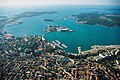
Aerial picture of Pula (Croatia)

The promenade of Poreč (Croatia)
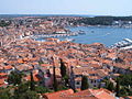
Rovinj, as seen from the bell tower of the church of Saint Eufemia (Croatia)

Motovun (Croatia)

Lim canal (Croatia)

The Praetorian Palace in Koper (Slovenia)

Old town of Piran (Slovenia)

Port in Muggia (Italy)
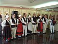
Traditional folk costume of Istrian Croats

Vineyards of Istria


Major towns and municipalities of Istria[]
This list includes towns and municipalities of Istria with populations estimated to be higher than 8,000 people.[30]
See also[]
- List of Istrians
- March of Istria
- Istrian exodus
- Istrian Italians
References[]
- Notes
- ^ Jump up to: a b Marcel Cornis-Pope, John Neubauer, History of the literary cultures of East-Central Europe: junctures and disjunctures in the 19th And 20th Centuries, John Benjamins Publishing Co. (2006), ISBN 90-272-3453-1
- ^ Jump up to: a b Alan John Day, Roger East, Richard Thomas, A political and economic dictionary of Eastern Europe, Routledge, 1sr ed. (2002), ISBN 1-85743-063-8
- ^ Leonhard Schmitz, A manual of ancient geography, pg. 131, The British Library (2010), ISBN B003MNGWVI
- ^ Wilkes, J. J. The Illyrians, 1992,ISBN 0-631-19807-5, page 183,"... We may begin with the Venetic peoples, Veneti, Carni, Histri and Liburni, whose language set them apart from the rest of the Illyrians...."
- ^ M. Blečić, Prilog poznavanju antičke Tarsatike, VAMZ, 3.s., XXXIV 65-122 (2001), UDK 904:72.032 (3:497.5), pages 70, 71
- ^ Šonje, Ante. Crkvena arhitektura (L'architettura sacra). pp. 45–49, 217, 270.
- ^ Bratož, Rajko (1989). The development of the early Christian research in Slovenia and Istria between 1976 and 1986 [article] Lyon, Vienne, Grenoble, Genève, Aoste, 21-28 septembre 1986. Publications de l'École Française de Rome. p. 2370.
- ^ Mengoli, Liliana Martissa. "Alto Medioevo". Coordinamento Adriatico. Archived from the original on 10 March 2021. Retrieved 11 March 2021.
- ^ "Gregory's letter to Gulfaris at Catholic Culture". Retrieved 11 March 2021.
- ^ Martyn, John R. C (2012). Pope Gregory's Letter-Bearers: A Study of the Men and Women who carried letters for Pope Gregory the Great. Cambridge Scholars Publishing. p. 65. ISBN 978-1-443-83918-1.
- ^ Željko Rapanić; (2013) O početcima i nastajanju Dubrovnika (The origin and formation of Dubrovnik. additional considerations) p. 94; Starohrvatska prosvjeta, Vol. III No. 40, [1]
- ^ Oto Luthar, ed. (2008). The land between : a history of Slovenia. Frankfurt am Main: Peter Lang. p. 100. ISBN 978-3-631-57011-1.
- ^ John Mason Neale, Notes Ecclesiological & Picturesque on Dalmatia, Croatia, Istria, Styria, with a visit to Montenegro, pg. 76, J.T. Hayes - London (1861)
- ^ "Historic Urban Cores: Izola". REVITAS – Revitalisation of the Istrian hinterland and tourism in the Istrian hinterland. Archived from the original on 17 November 2015. Retrieved 1 June 2015.
- ^ Stephens, Henry Morse (2008). Revolutionary Europe, 1789–1815, BiblioLife. p. 192. ISBN 0-559-25438-5.
- ^ Angelo Filippuzzi. La campagna del 1866 nei documenti militari austriaci: operazioni terrestri. Padova, Antoniana. p. 396.
- ^ Jump up to: a b c Minahan, James (2000). One Europe, Many Nations: A Historical Dictionary of European National Groups. Greenwood Publishing Group. pp. 340–341. ISBN 978-0313309847.
- ^ Hehn, Paul N. (2005). A Low, Dishonest Decade: The Great Powers, Eastern Europe and the Economic Origins of World War II. A&C Black. p. 45.
- ^ Office of the President of the Republic of Slovenia (5 May 2010). "President Hails Heroism of Slovenian WWII Patriots". Government Communication Office. Retrieved 9 September 2010.[permanent dead link]
- ^ Rawson, Andrew (2013). Organizing Victory: The War Conferences 1941–1945. Stroud, Gloucestershire, UK: History Press. ISBN 9780752489254.
- ^ Jump up to: a b Katia Pizzi, A city in search of an author: the literacy identity of Trieste, pg. 23, Sheffield Academic Press (2002), ISBN 1-84127-284-1
- ^ Julio Aramberri, Richard Butler, Tourism Development, pg. 195
- ^ see also Census 2001
- ^ Italian Istria infosite Archived 2014-10-09 at the Wayback Machine, unione-italiana.hr; accessed 4 August 2015.
- ^ Klein-Pejšová, Rebekah (12 February 2015). Mapping Jewish Loyalties in Interwar Slovakia. Indiana University Press. ISBN 9780253015624. Retrieved 4 May 2018 – via Google Books.
- ^ "Spezialortsrepertorium der österreichischen Länder I-XII, Wien, 1915–1919". Archived from the original on 2013-05-29. Retrieved 2020-04-20.
- ^ "Population by Ethnicity, by Towns/Municipalities, 2011 Census: County of Istria". Census of Population, Households and Dwellings 2011. Zagreb: Croatian Bureau of Statistics. December 2012.
- ^ Statistical Office of the Republic of Slovenia Archived 2009-05-27 at the Wayback Machine, Population Census 2002 results, stat.si; accessed 4 August 2015.
- ^ Salminen, Tapani (1999). "UNESCO Red Book on Endangered Languages". Helsinki.fi. Archived from the original on 22 August 2012. Retrieved 9 September 2010.
- ^ "Istra (County, Croatia) - Population Statistics, Charts, Map and Location". www.citypopulation.de. Retrieved 2020-12-02.
Further reading[]
- Ashbrook, John (December 2005). "Self-perceptions, denials, and expressions: Istrianity in a nationalizing Croatia, 1990-1997". Nationalities Papers. 33 (4): 459–487. doi:10.1080/00905990500353923. S2CID 143942069.
- Luigi Tomaz, Il confine d'Italia in Istria e Dalmazia. Duemila anni di storia, Presentazione di Arnaldo Mauri, Think ADV, Conselve 2008.
- Luigi Tomaz, In Adriatico nel secondo millennio, Presentazione di Arnaldo Mauri, Think ADV, Conselve, 2010.
- Louis François Cassas "Travels in Istria and Dalmatia, drawn up from the itinerary of L. F. Cassas" Eng trans. from 1802 Fr pub.
External links[]
| Wikimedia Commons has media related to Istria. |
| Wikivoyage has a travel guide for Istria. |
- . Encyclopædia Britannica. 14 (11th ed.). 1911.
- Istria on the Internet (a non-commercial, non-political, cultural site)
- Old postcards of Istria
- A Brief History of Istria / Darko Darovec
- Results of Austrian Census on Dec. 31st, 1910 Archived 2018-03-14 at the Wayback Machine
- Istrian cultural heritage. Bukaleta Kazun, wall paintings
- Travels in Istria and Dalmatia: drawn up from the itinerary of L. F. Cassas on Google Books

Coordinates: 45°15′40″N 13°54′16″E / 45.26111°N 13.90444°E

| show Authority control |
|---|
- Istria
- Peninsulas of Croatia
- Geography of Italy
- Geography of Southern Europe
- Peninsulas of Slovenia
- Austrian Littoral
- Kingdoms and countries of Austria-Hungary
- Former states and territories in Slovenia