Buje
Buje | |
|---|---|
Town | |
| Town of Buje Grad Buje - Città di Buie[1] | |
 | |
 Flag | |
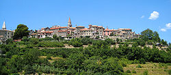
 Buje Location of Buje in Croatia | |
| Coordinates: 45°25′N 13°40′E / 45.417°N 13.667°ECoordinates: 45°25′N 13°40′E / 45.417°N 13.667°E | |
| Country | |
| County | |
| Government | |
| • Mayor | Fabrizio Vižintin (IDS) |
| Population (31 March 2011) | |
| • Town | 5,182 |
| • Urban | 2,671 |
| Time zone | UTC+1 (CET) |
| • Summer (DST) | UTC+2 (CEST) |
| Website | www |

Buje (Italian: Buie) is a town situated in Istria, Croatia's westernmost peninsula.
Buje was known as the "sentinel of Istria" for its hilltop site located 10 km (6.2 mi) inland from the Adriatic Sea.
History[]
Buje has a rich history; traces of life in the region date back to prehistoric times. The town developed from a Roman and Venetian settlement into a medieval town. Buje was part of the Republic of Venice from 1358 until 1797, when the Treaty of Campo Formio handed it over to Austria. It was annexed by France after the Treaty of Schönbrunn in 1809 but restored to Austria at the Congress of Vienna in 1815. Buje passed to Italy at the end of World War I in 1918, where it remained until 1945. In 1947, it became part of the Free Territory of Trieste Zone B, which was administered by Yugoslavia. In October 1954, Zone B together with Buje was united with the Socialist Republic of Croatia, and remains part of independent Croatia today.
A Baroque style Church of Our Lady of Mercy from the 16th century, built on the foundations of an ancient Roman temple, dominates the central square.[2] The old city was protected with stone fortifications, part of which have been preserved to modern times. With its narrow streets and a central square, the old town is a fine example of Medieval architecture with strong Venetian Renaissance architecture influences, as in the rest of the region.
After World War II Buje developed into an industrial, cultural, and economic center of this region of northwestern Croatia.
Geography[]
The town is located in northwest Istria, 13 km from Umag. The town has an area of 103.28 km2.[3]
Buje has become a modern regional center, and outside of the old town center a modern city has sprung. Despite its development, the city has retained some features from its historical periods.
Being situated on a hill, the old town section offers views of the surrounding scenery, dominated by Mediterranean flora, vineyards, and olive groves.
To its visitors today, Buje offers a blend of gentle Mediterranean climate, regional cuisine, and a quiet setting away from the more touristic Istrian coastal resorts.
Demographics[]


| Year | Pop. | ±% |
|---|---|---|
| 1880 | 6,980 | — |
| 1890 | 7,578 | +8.6% |
| 1900 | 8,311 | +9.7% |
| 1910 | 8,682 | +4.5% |
| 1921 | 8,989 | +3.5% |
| 1931 | 8,601 | −4.3% |
| 1948 | 8,013 | −6.8% |
| 1953 | 5,763 | −28.1% |
| 1961 | 5,344 | −7.3% |
| 1971 | 4,376 | −18.1% |
| 1981 | 4,957 | +13.3% |
| 1991 | 5,421 | +9.4% |
| 2001 | 5,340 | −1.5% |
| 2011 | 5,182 | −3.0% |
| Source: Naselja i stanovništvo Republike Hrvatske 1857–2001, DZS, Zagreb, 2005 | ||
The population of the whole administrative area of the Town of Buje is 5,182, with 2,671 in the titular settlement itself.[4]
Settlements[]
The Town of Buje consist of 21 settlements.
Languages[]
According to the 1921 census, there were 7,431 Italians, 6 Croats, 8 Slovenes and 20 foreigners.[5]
According to the 2011 census results, 58.39% of the town’s population had the Croatian language as their mother tongue, and 33.25% had the Italian language.[6]
Buje has a high number of Italians, and an Italian language school, the "Leonardo da Vinci". It was 50% Italian in 1991, when the town’s limits included Grožnjan.
References[]
- ^ "Statut Grada Buja" [Statute of the City of Buje] (PDF) (in Croatian). 2009. Article 2. Retrieved 17 January 2016.
- ^ https://www.coloursofistria.com/en/buje/art-and-culture/church-of-st.-mary-of-mercy
- ^ "Pročišćeni tekst Prostornog plana uređenja Grada Buja" (PDF) (in Croatian). 2019. Retrieved 21 July 2020.
- ^ "Population by Age and Sex, by Settlements, 2011 Census: Buje". Census of Population, Households and Dwellings 2011. Zagreb: Croatian Bureau of Statistics. December 2012.
- ^ "VG.PDF".
- ^ "Population by Mother Tongue, by Towns/Municipalities, 2011 Census: County of Istria". Census of Population, Households and Dwellings 2011. Zagreb: Croatian Bureau of Statistics. December 2012.
Further reading[]
- "Buje". Istrapedia (in Croatian). Retrieved 30 October 2019.
External links[]
| Wikimedia Commons has media related to Buje. |
- Official website (in Croatian) (in Italian)
- Tourist-croatia.com: Tourism in Buje—(in English)
| hide Subdivisions of Istria County | ||
|---|---|---|
| Cities and towns |  | |
| Municipalities | ||
| Authority control: National libraries |
|---|
- Cities and towns in Croatia
- Populated places in Istria County
- Italian-speaking territorial units in Croatia