Vrsar
This article needs additional citations for verification. (May 2010) |
show This article may be expanded with text translated from the corresponding article in Croatian. (May 2020) Click [show] for important translation instructions. |
Vrsar/Orsera | |
|---|---|
Municipality | |
| Vrsar/Orsera Municipality Općina Vrsar - Comune di Orsera[1] | |
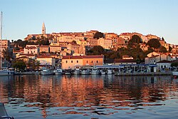 Vrsar old harbor | |
 Flag | |
 Vrsar/Orsera Location of Vrsar/Orsera in Croatia | |
| Coordinates: 45°09′N 13°36′E / 45.150°N 13.600°ECoordinates: 45°09′N 13°36′E / 45.150°N 13.600°E | |
| Country | |
| County | Istria |
| Government | |
| • Major | Ivan Gerometta[3] (IDS) |
| Population (2011)[2] | |
| • Total | 2,162 |
| Time zone | UTC+1 (CET) |
| • Summer (DST) | UTC+2 (CEST) |
| Website | www |

Vrsar (Venetian: Orsera) is a small seaside town and a municipality in Istria, Croatia located 9 kilometers south of Poreč.[4][5] The historical center is located on top of a hill, including the St. Martin parish church and the 40-meter high bell tower. In the 20th century, the town expanded down the hill, into the surrounding area.[6] It is a popular summer destination with large campsites, private accommodation units and a modern marina.[7] It is the home of the large Koversada Naturist Campsite, the oldest in Istria.
Municipality[]
The municipality consists of Vrsar as the largest settlement and 8 villages in the interior, including Begi, Bralići, Delići, Flengi, Gradina, Kloštar, Kontešići and Marasi. Funtana, the nearby coastal town, was a part of the Vrsar municipality until 2006. Town council has 11 representatives[8] elected every four years. Local government is based in a refurbished historical building in the central Degrassi Square.[9]
History[]
Vrsar was part of the Republic of Venice (1420-1797), then of the French Kingdom of Italy firstly, and Illyrian Provinces till 1814. After the fall of Napoleon, it was part of the Austrian Littoral up to 1915 then became part of Kingdom of Italy (1918–1947) after which it was part of Yugoslavia until 1991 when incorporated in the Republic of Croatia.[10]
Koversada[]
Koversada Naturist Park is 2 kilometres south of Vrsar. It has over 1100 camping emplacements, 350 with their own water and 600 with internet connections.[11] It is situated in ninety hectares of olive groves on the shore and on a tiny island. It is linked to the town by a tourist train.[11]
References[]
- ^ "Statut općine Vrsar" (PDF) (in Croatian). 28 June 2013. Retrieved 26 May 2020.
- ^ "Population by Age and Sex, by Settlements, 2011 Census: Vrsar". Census of Population, Households and Dwellings 2011. Zagreb: Croatian Bureau of Statistics. December 2012.
- ^ "Administration". Vrsar.hr. Vrsar municipality. Retrieved 19 March 2021.
- ^ "Vrsar - tourist guide". Adriagate. Retrieved 2019-12-15.
- ^ Sinke (2016-09-12). "Three Reasons to Visit Vrsar". Croatia Times. Archived from the original on 2019-12-15. Retrieved 2019-12-15.
- ^ Baldini, Marino. "Vrsar". Istrapedia. Retrieved 19 March 2021.
- ^ "Marina Vrsar". Montraker.hr. Montraker. Retrieved 19 March 2021.
- ^ "Općinsko vijeće". Vrsar.hr. Retrieved 19 March 2021.
- ^ "Jedinstveni upravni odjel". Vrsar.hr. Retrieved 19 March 2021.
- ^ "Vrsar - Travel guide for tourists in Istria, Croatia". Istria Sun. Retrieved 2019-12-15.
- ^ Jump up to: a b "Naturist campsite Koversada - Vrsar, Istria - CAMPING.HR". www.camping.hr. Retrieved 14 July 2021.
| Wikimedia Commons has media related to Vrsar. |
| show Subdivisions of Istria County |
|---|

| show Authority control |
|---|
- Municipalities of Croatia
- Populated places in Istria County
- Italian-speaking territorial units in Croatia